Junctions

- City Square
- Bank of England
- Town Hall
- Civic Hall
- Cathedral
- St. Johns
- Merrion
- Grand Theatre
- North Street
- Regent Street
- Eastgate
- Quarry Hill
- Crown Point
- Parish Church
- The Calls
- Bridge End
- Sovereign
- Bishopgate
The Leeds city centre Loop Road was a one-way traffic route of approximately two miles within the city centre of Leeds, which encircled a large section of the shopping and retail district. It comprised the following eighteen junctions. It was finally removed as being a complete loop after Leeds City Council closed access to City Square in September 2022.
West Yorkshire is a metropolitan and ceremonial county in the Yorkshire and Humber Region of England. It is an inland and upland county having eastward-draining valleys while taking in the moors of the Pennines. West Yorkshire came into existence as a metropolitan county in 1974 after the reorganisation of the Local Government Act 1972 which saw it formed from a large part of the West Riding of Yorkshire. The county had a recorded population of 2.3 million in the 2011 Census making it the fourth-largest by population in England. The largest towns are Huddersfield, Castleford, Batley, Bingley, Pontefract, Halifax, Brighouse, Keighley, Pudsey, Morley and Dewsbury. The three cities of West Yorkshire are Bradford, Leeds and Wakefield.
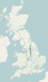
The A61 is a major trunk road in England connecting Derby and Thirsk in North Yorkshire by way of Alfreton, Clay Cross, Chesterfield, Sheffield, Barnsley, Wakefield, Leeds, Harrogate and Ripon. The road is closely paralleled by the M1 motorway between Derby and Leeds.

Liverpool James Street railway station is a railway station located in the centre of Liverpool, England, situated on the Wirral Line of the Merseyrail network. James Street is an underground station with access to the platforms via lifts from the James Street booking hall. At certain times the platforms are accessed via a pedestrian tunnel from the India Buildings on Water Street. As of 2013/14, James Street was the fifth-busiest station on the Merseyrail network.

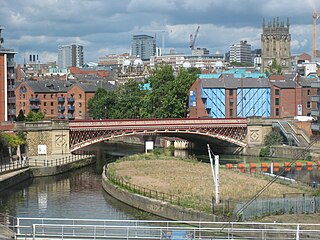
City Square is a paved area north of Leeds railway station at the junction of Park Row to the east and Wellington Street to the south. It is a triangular area where six roads meet: Infirmary Street and Park Row to the north, Boar Lane and Bishopsgate Street to the south-east, and Quebec Street and Wellington Street to the south-west. The only building with a direct frontage is the former General Post Office, on the north-west side.

The Headrow is an avenue in Leeds city centre, West Yorkshire, England.

Millennium Square is a city square in the Civic Quarter of Leeds, West Yorkshire, England. It was Leeds's flagship project to mark the year 2000, and was jointly funded by Leeds City Council and the Millennium Commission. Total cost of production was £12 million.

Leeds Civic Hall is a municipal building located in the civic quarter of Leeds, West Yorkshire, England. It replaced Leeds Town Hall as the administrative centre in 1933. The Civic Hall houses Leeds City Council offices, council chamber and a banqueting hall, and is a Grade II* listed building. A city landmark, two 2.3 metres high gold-leafed owls top its twin towers, decorations which are joined by four more owls on columns in Millennium Square, which sits to the front, and a gilded clock on both sides.

Leeds General Infirmary, also known as the LGI, is a large teaching hospital based in the centre of Leeds, West Yorkshire, England, and is part of the Leeds Teaching Hospitals NHS Trust. Its previous name The General Infirmary at Leeds is still sometimes used.
Leeds city centre is the central business district of Leeds, West Yorkshire, England. It is roughly bounded by the Inner Ring Road to the north and the River Aire to the south and can be divided into several quarters.

Downtown Toronto is the main central business district of Toronto, Ontario, Canada. Located entirely within the district of Old Toronto, it is approximately 16.6 square kilometres in area, bounded by Bloor Street to the northeast and Dupont Street to the northwest, Lake Ontario to the south, the Don Valley to the east, and Bathurst Street to the west. It is also the home of the municipal government of Toronto and the Government of Ontario.

Leeds is a city and the administrative centre of the City of Leeds district in West Yorkshire, England. It is built around the River Aire and is in the eastern foothills of the Pennines. It is also the third-largest settlement in England, after London and Birmingham.

Transport within Leeds consists of extensive road, bus and rail networks. The city has good rail and road links to the rest of the country. Leeds railway station is one of the busiest in Britain, and Leeds is connected to the national road network via the A1(M) motorway, M1 motorway and M62 motorway. The city is served by Leeds Bradford Airport.

Leeds Town Hall is a 19th-century municipal building on The Headrow, Leeds, West Yorkshire, England. Planned to include law courts, a council chamber, offices, a public hall, and a suite of ceremonial rooms, it was built between 1853 and 1858 to a design by the architect Cuthbert Brodrick. With the building of the Civic Hall in 1933, some of these functions were relocated, and after the construction of the Leeds Crown Court in 1993, the Town Hall now serves mainly as a concert, conference and wedding venue, its offices still used by some council departments. It was designated a Grade I listed building in 1951.
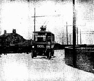
The Leeds trolleybus system served the West Riding of Yorkshire city of Leeds in England between 1911 and 1928. In May 2016, plans to construct a new system, the New Generation Transport (NGT) project, were refused approval from the UK Department for Transport, following a negative report from the planning inquiry.

The architecture of Leeds, a city and metropolitan borough in West Yorkshire, England, encompasses a wide range of architectural styles and notable buildings. As with most northern industrial centres, much of Leeds' prominent architecture is of the Victorian era. However, the City of Leeds also contains buildings from as early as the Middle Ages such as Kirkstall Abbey, one of Britain's best preserved ruined Cistercian monasteries, as well as examples of 20th century industrial architecture, particularly in the districts of Hunslet and Holbeck.

Park Row is a street in Leeds city centre, West Yorkshire, England. It divides the main financial districts from the main retail districts and forms a spine between City Square and The Headrow, two of Leeds' most sought-after addresses. The street forms the western flank of the Public Transport Box, and as such is mostly reserved for buses, taxis and cyclists, especially since reconfiguration 202-2021 as part of city-centre-wide traffic infrastructure changes.

Chapel Allerton is an inner suburb of north-east Leeds, West Yorkshire, England, 2 miles (3.2 km) from the city centre.
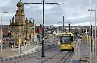
The Oldham and Rochdale Line (ORL) is a tram line of the Manchester Metrolink in Greater Manchester running from Manchester city centre to Rochdale town centre via Oldham, using most of the trackbed of the former Oldham Loop Line which closed in 2009. The line was re-opened in a modified form as a tramway between 2012 and 2014, as part of phase three of the system's expansion.

The Majestic is a Grade II listed building on City Square, Leeds, occupying the corner of Quebec Street and Wellington Street.