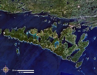
This is a list of lakes in the Kerguelen Islands , a group of subantarctic islands belonging to France in the southern Indian Ocean.
| Name | Location | Coordinates | Elevation | Size | Depth |
|---|---|---|---|---|---|
| Lac Aglaé | Main Island | 49°13′47″S69°16′25″E / 49.22972°S 69.27361°E | 220 metres (720 ft) | 5 sq km | 50m |
| Lac Alicia | Australia Island | 49°28′39″S69°53′30″E / 49.47750°S 69.89167°E | 10 metres (33 ft) | ||
| Lac d'Argoat | Central Plateau, Main Island | 49°28′49″S69°43′12″E / 49.48028°S 69.72000°E | 10 metres (33 ft) | ||
| Lac d'Armor | Central Plateau, Main Island | 49°27′17″S69°42′28″E / 49.45472°S 69.70778°E | 1 metre (3.3 ft) | ||
| Lac d'Asté | Joffre Presque-isle, Main Island | 49°04′55″S69°32′00″E / 49.08194°S 69.53333°E | 31 metres (102 ft) | ||
| Lac Aval | Courbet Peninsula, Main Island | 49°15′19″S69°57′48″E / 49.25528°S 69.96333°E | 67 metres (220 ft) | ||
| Lac Bontemps | Main Island | 49°17′41″S69°27′11″E / 49.29472°S 69.45306°E | 5 metres (16 ft) | ||
| Lac Börgen | Rallier du Baty Peninsula, Main Island | 49°31′22″S69°06′16″E / 49.52278°S 69.10444°E | 24 metres (79 ft) | ||
| Lac de la Botte | Joffre Presque-isle, Main Island | 49°03′20″S69°34′55″E / 49.05556°S 69.58194°E | 30 metres (98 ft) | ||
| Lac du Bouchet | Central Plateau, Main Island | 49°22′33″S69°13′47″E / 49.37583°S 69.22972°E | 240 metres (790 ft) | ||
| Lac Brunehilde | Central Plateau, Main Island | 49°23′50″S69°25′50″E / 49.39722°S 69.43056°E | 40 metres (130 ft) | ||
| Lac de Chamonix | Main Island | 49°13′10″S69°08′30″E / 49.21944°S 69.14167°E | 120 metres (390 ft) | ||
| Lac Christiane | Courbet Peninsula, Main Island | 49°20′32″S69°57′04″E / 49.34222°S 69.95111°E | 367 metres (1,204 ft) | ||
| Lac Chun | Central Plateau, Main Island | 49°20′46″S69°41′38″E / 49.34611°S 69.69389°E | 180 metres (590 ft) | ||
| Lac de Courmayeur | Central Plateau, Main Island | 49°20′46″S69°29′36″E / 49.34611°S 69.49333°E | 164 metres (538 ft) | ||
| Lac de Cristal | Joffre Presque-isle, Main Island | 49°03′24″S69°33′09″E / 49.05667°S 69.55250°E | 48 metres (157 ft) | ||
| Lac de la Croix du Sud | Main Island | 49°13′12″S69°23′22″E / 49.22000°S 69.38944°E | 36 metres (118 ft) | ||
| Lac de la Déception | Central Plateau, Main Island | 49°25′13″S69°39′07″E / 49.42028°S 69.65194°E | 200 metres (660 ft) | ||
| Lac des Deux Îlots | Central Plateau, Main Island | 49°21′30″S69°33′00″E / 49.35833°S 69.55000°E | 153 metres (502 ft) | ||
| Lac Eaton | Gauss Presque-isle, Main Island | 49°23′35″S69°53′35″E / 49.39306°S 69.89306°E | 33 metres (108 ft) | ||
| Lac Elsa | Central Plateau, Main Island | 49°19′32″S69°32′46″E / 49.32556°S 69.54611°E | 102 metres (335 ft) | ||
| Lac Emmy | Central Plateau, Main Island | 49°20′31″S69°35′13″E / 49.34194°S 69.58694°E | 74 metres (243 ft) | ||
| Lac d'Entr'Aigues | Central Plateau, Main Island | 49°26′18″S69°27′42″E / 49.43833°S 69.46167°E | 92 metres (302 ft) | ||
| Lac d'Enfer | Central Plateau, Main Island | 49°29′14″S69°41′59″E / 49.48722°S 69.69972°E | 40 metres (130 ft) | ||
| Lacs d'Entremont | Gallieni Peninsula, Main Island | 49°28′53″S69°28′29″E / 49.48139°S 69.47472°E | 178 metres (584 ft) | ||
| Lac Euphrosine | Main Island | 49°14′05″S69°23′40″E / 49.23472°S 69.39444°E | −1 metre (−3.3 ft) | ||
| Lac des Fougères | Central Plateau, Main Island | 49°25′32″S69°40′36″E / 49.42556°S 69.67667°E | 92 metres (302 ft) | ||
| Lac Francine | Central Plateau, Main Island | 49°21′25″S69°20′53″E / 49.35694°S 69.34806°E | 386 metres (1,266 ft) | ||
| Lac Gandillot | Central Plateau, Main Island | 49°30′00″S69°45′55″E / 49.50000°S 69.76528°E | 38 metres (125 ft) | ||
| Lac de Guilvinec | Central Plateau, Main Island | 49°23′47″S69°42′53″E / 49.39639°S 69.71472°E | 35 metres (115 ft) | ||
| Lac Hanna | Central Plateau, Main Island | 49°18′52″S69°30′49″E / 49.31444°S 69.51361°E | 280 metres (920 ft) | ||
| Lac d'Hermance | Central Plateau, Main Island | 49°27′18″S69°34′34″E / 49.45500°S 69.57611°E | 13 metres (43 ft) | ||
| Lac Hervé | Loranchet Peninsula, Main Island | 48°52′53″S68°50′01″E / 48.88139°S 68.83361°E | 29 metres (95 ft) | ||
| Lac de l'Impasse | Rallier du Baty Peninsula, Main Island | 49°31′34″S68°51′38″E / 49.52611°S 68.86056°E | 20 metres (66 ft) | ||
| Lac Isou | Loranchet Peninsula, Main Island | 49°00′25″S68°50′36″E / 49.00694°S 68.84333°E | 181 metres (594 ft) | ||
| Lac des Jaspes | Courbet Peninsula, Main Island | 49°18′05″S69°57′50″E / 49.30139°S 69.96389°E | 478 metres (1,568 ft) | ||
| Lac Jaune | Main Island | 49°27′37″S69°08′35″E / 49.46028°S 69.14306°E | 9 metres (30 ft) | ||
| Lac Josette | Central Plateau, Main Island | 49°18′52″S69°18′35″E / 49.31444°S 69.30972°E | 159 metres (522 ft) | ||
| Lac de Jougne | Gallieni Peninsula, Main Island | 49°31′31″S69°21′43″E / 49.52528°S 69.36194°E | 74 metres (243 ft) | ||
| Lac Koeslin | Central Plateau, Main Island | 49°24′16″S69°36′15″E / 49.40444°S 69.60417°E | 57 metres (187 ft) | ||
| Lac des Korrigans | Gauss Presque-isle, Main Island | 49°21′35″S69°47′30″E / 49.35972°S 69.79167°E | 78 metres (256 ft) | ||
| Lac Lancelot | Central Plateau, Main Island | 49°28′00″S69°40′12″E / 49.46667°S 69.67000°E | 45 metres (148 ft) | ||
| Lac de la Malchance | Loranchet Peninsula, Main Island | 49°02′35″S68°51′50″E / 49.04306°S 68.86389°E | 178 metres (584 ft) | ||
| Lac Margot | Courbet Peninsula, Main Island | 49°15′19″S69°57′48″E / 49.25528°S 69.96333°E | 67 metres (220 ft) | ||
| Lac Marioz | Central Plateau, Main Island | 49°25′28″S69°18′04″E / 49.42444°S 69.30111°E | 99 metres (325 ft) | ||
| Lac Marville | Courbet Peninsula, Main Island | 48°08′59″S70°28′20″E / 48.14972°S 70.47222°E | 1 metre (3.3 ft) | ||
| Lac des Megalestris | Gallieni Peninsula, Main Island | 49°33′10″S69°16′15″E / 49.55278°S 69.27083°E | 19 metres (62 ft) | ||
| Lac Mercure | Gauss Presque-isle, Main Island | 49°23′16″S69°50′42″E / 49.38778°S 69.84500°E | 67 metres (220 ft) | ||
| Lac Michèle | Loranchet Peninsula, Main Island | 48°59′45″S68°57′39″E / 48.99583°S 68.96083°E | 110 metres (360 ft) | ||
| Lac Nathalie | Rallier du Baty Peninsula, Main Island | 49°31′00″S69°08′52″E / 49.51667°S 69.14778°E | 67 metres (220 ft) | ||
| Lac Noir | Central Plateau, Main Island | 49°29′06″S69°43′45″E / 49.48500°S 69.72917°E | 17 metres (56 ft) | ||
| Lac Parsifal | Central Plateau, Main Island | 49°25′43″S69°36′50″E / 49.42861°S 69.61389°E | 126 metres (413 ft) | ||
| Lac du Présalé | Joffre Presque-isle, Main Island | 49°01′46″S69°32′16″E / 49.02944°S 69.53778°E | −2 metres (−6.6 ft) | ||
| Lac de la Réserve | Rallier du Baty Peninsula, Main Island | 49°26′10″S68°57′00″E / 49.43611°S 68.95000°E | 30 metres (98 ft) | ||
| Lac Saturne | Gauss Presque-isle, Main Island | 49°22′50″S69°46′55″E / 49.38056°S 69.78194°E | 77 metres (253 ft) | ||
| Lac des Saumons | Courbet Peninsula, Main Island | 49°15′30″S69°59′00″E / 49.25833°S 69.98333°E | 68 metres (223 ft) | ||
| Lac Schimper | Central Plateau, Main Island | 49°20′38″S69°40′29″E / 49.34389°S 69.67472°E | 163 metres (535 ft) | ||
| Lac Sibélius | Central Plateau, Main Island | 49°23′42″S69°32′29″E / 49.39500°S 69.54139°E | 72 metres (236 ft) | ||
| Lac de la Source | Courbet Peninsula, Main Island | 49°19′02″S69°57′36″E / 49.31722°S 69.96000°E | 428 metres (1,404 ft) | ||
| Lac Supérieur | Courbet Peninsula, Main Island | 49°16′45″S70°02′06″E / 49.27917°S 70.03500°E | 68 metres (223 ft) | ||
| Lac Thalie | Main Island | 49°13′55″S69°19′45″E / 49.23194°S 69.32917°E | 124 metres (407 ft) | ||
| Lac Tristan | Central Plateau, Main Island | 49°22′14″S69°32′11″E / 49.37056°S 69.53639°E | 34 metres (112 ft) | ||
| Lac Toulaz | Central Plateau, Main Island | 49°24′10″S69°30′37″E / 49.40278°S 69.51028°E | 143 metres (469 ft) | ||
| Lac des Trois Cantons | Loranchet Peninsula, Main Island | 48°57′40″S69°02′57″E / 48.96111°S 69.04917°E | 25 metres (82 ft) | ||
| Lac des Trois Glaciers | Central Plateau, Main Island | 49°22′16″S69°19′02″E / 49.37111°S 69.31722°E | 326 metres (1,070 ft) | ||
| Lac des Trois Enseignes | Courbet Peninsula, Main Island | 49°19′27″S69°49′31″E / 49.32417°S 69.82528°E | 246 metres (807 ft) | ||
| Trois Lacs | Courbet Peninsula, Main Island | 49°19′52″S69°57′05″E / 49.33111°S 69.95139°E | 430 metres (1,410 ft) | ||
| Lac des Truites | Courbet Peninsula, Main Island | 49°15′50″S70°00′00″E / 49.26389°S 70.00000°E | 68 metres (223 ft) | ||
| Lac Valérie | Loranchet Peninsula, Main Island | 48°52′22″S68°52′19″E / 48.87278°S 68.87194°E | 50 metres (160 ft) | ||
| Lac du Val Mort | Main Island | 49°17′02″S68°52′36″E / 49.28389°S 68.87667°E | 13 metres (43 ft) | ||
| Lac de la Vendéenne | Gallieni Peninsula, Main Island | 49°35′21″S69°39′34″E / 49.58917°S 69.65944°E | 541 metres (1,775 ft) | ||
| Lac Yseult | Central Plateau, Main Island | 49°22′38″S69°34′40″E / 49.37722°S 69.57778°E | 541 metres (1,775 ft) | ||
| Lac Zizi | Loranchet Peninsula, Main Island | 49°08′15″S68°51′45″E / 49.13750°S 68.86250°E | 445 metres (1,460 ft) |

The Great Lakes, also called the Great Lakes of North America or the Laurentian Great Lakes, is a series of large interconnected freshwater lakes with sea-like characteristics in the mid-east region of North America that connect to the Atlantic Ocean via the Saint Lawrence River. They are Lakes Superior, Michigan, Huron, Erie, and Ontario and are in general on or near the Canada–United States border. Hydrologically, there are four lakes, because lakes Michigan and Huron join at the Straits of Mackinac. The Great Lakes Waterway enables modern travel and shipping by water among the lakes.

An island is an isolated piece of habitat that is surrounded by a dramatically different habitat, such as water. Very small islands such as emergent land features on atolls can be called islets, skerries, cays or keys. An island in a river or a lake island may be called an eyot or ait, and a small island off the coast may be called a holm. Sedimentary islands in the Ganges delta are called chars. A grouping of geographically or geologically related islands, such as the Philippines, is referred to as an archipelago.

Lake Ontario is one of the five Great Lakes of North America. It is surrounded on the north, west, and southwest by the Canadian province of Ontario, and on the south and east by the U.S. state of New York, whose water boundaries meet in the middle of the lake.

Lake Michigan is one of the five Great Lakes of North America. It is the second-largest of the Great Lakes by volume and the third-largest by surface area, after Lake Superior and Lake Huron. To the east, its basin is conjoined with that of Lake Huron through the narrow Straits of Mackinac, giving it the same surface elevation as its easterly counterpart; the two are technically a single lake.

Lake Superior is the largest and northernmost of the Great Lakes of North America, and among freshwater lakes, it is the world's largest by surface area and the third-largest by volume. It holds 10% of the world's surface fresh water. It is shared by Ontario, Canada, to the north, and states in the United States in other directions: Minnesota to the west, and Wisconsin and the Upper Peninsula of Michigan to the south. Lake Superior is the most northerly and most westerly of the Great Lakes chain, and the highest in elevation. It drains into Lake Huron via St. Mary's River.

Lake Champlain is a natural freshwater lake in North America mainly within the borders of the United States but also across the Canada–U.S. border into the Canadian province of Quebec.

Lake Huron is one of the five Great Lakes of North America. Hydrologically, it comprises the easterly portion of Lake Michigan–Huron, having the same surface elevation as its westerly counterpart, to which it is connected by the 5-mile-wide (8.0 km), 20-fathom-deep Straits of Mackinac. It is shared on the north and east by the Canadian province of Ontario and on the south and west by the U.S. state of Michigan. The name of the lake is derived from early French explorers who named it for the Huron people inhabiting the region. The Huronian glaciation was named from evidence collected from Lake Huron region. The northern parts of the lake include the North Channel and Georgian Bay. Saginaw Bay is located in the southwest corner of the lake. The main inlet is the St. Marys River, and the main outlet is the St. Clair River.

The Great Salt Lake is the largest saltwater lake in the Western Hemisphere, and the eighth-largest terminal lake in the world. It lies in the northern part of the U.S. state of Utah, and has a substantial impact upon the local climate, particularly through lake-effect snow. It is a remnant of Lake Bonneville, a prehistoric body of water that covered much of western Utah.

A lagoon is a shallow body of water separated from a larger body of water by a narrow landform, such as reefs, barrier islands, barrier peninsulas, or isthmuses. Lagoons are commonly divided into coastal lagoons and atoll lagoons. They have also been identified as occurring on mixed-sand and gravel coastlines. There is an overlap between bodies of water classified as coastal lagoons and bodies of water classified as estuaries. Lagoons are common coastal features around many parts of the world.

Lake Titicaca is a large, deep, freshwater lake in the Andes on the border of Bolivia and Peru, often called the "highest navigable lake" in the world. By volume of water and by surface area, it is the largest lake in South America.
Manitoulin Island is an island in Lake Huron, located within the borders of the Canadian province of Ontario, in the bioregion known as Laurentia. With an area of 2,766 km2 (1,068 sq mi), it is the largest lake island in the world, large enough that it has over 100 inland lakes itself. In addition to the historic Anishinaabe and European settlement of the island, archeological discoveries at Sheguiandah have demonstrated Paleo-Indian and Archaic cultures dating from 10,000 BC to 2,000 BC.

Lake Winnipesaukee is the largest lake in the U.S. state of New Hampshire, located in the Lakes Region at the foothills of the White Mountains. It is approximately 21 miles (34 km) long (northwest-southeast) and from 1 to 9 miles wide (northeast-southwest), covering 69 square miles (179 km2)—71 square miles (184 km2) when Paugus Bay is included—with a maximum depth of 180 feet (55 m). The center area of the lake is called The Broads.

Georgian Bay is a large bay of Lake Huron, in the Laurentia bioregion. It is located entirely within the borders of Ontario, Canada. The main body of the bay lies east of the Bruce Peninsula and Manitoulin Island. To its northwest is the North Channel.

UTC−05:00 is an identifier for a time offset from UTC of −05:00. In North America, it is observed in the Eastern Time Zone during standard time, and in the Central Time Zone during the other eight months. The western Caribbean uses it year round.

Taal Volcano is a large caldera filled by Taal Lake in the Philippines. Located in the province of Batangas, the volcano is second of the most active volcanoes in the country, with 38 recorded historical eruptions, all of which were concentrated on Volcano Island, near the middle of Taal Lake. The caldera was formed by prehistoric eruptions between 140,000 and 5,380 BP.

Lake Macquarie or Awaba is Australia's largest coastal salt water lake. Located in the Hunter Region of New South Wales, it covers an area of 110 square kilometres (42.5 sq mi) and is connected to the Tasman Sea by a short channel. Most of the residents of the City of Lake Macquarie live near the shores of the lake.

A lake is an area filled with water, localized in a basin, surrounded by land, and set apart from any river or other outlet that serves to feed or drain the lake. Lakes lie on land and are not part of the ocean, although, like the much larger oceans, they do form part of the Earth's water cycle. Lakes are distinct from lagoons, which are generally coastal parts of the ocean. Lakes are typically larger and deeper than ponds, which also lie on land, though there are no official or scientific definitions. Lakes can be contrasted with rivers or streams, which usually flow in a channel on land. Most lakes are fed and drained by rivers and streams.