| Name | Location | Date Listed | Grid Ref. [note 1] | Geo-coordinates | Notes | HB Number [note 2] | Image |
|---|
|
| Currie Parish Church Manse Including Office Court At Rear And Garden Walls, Off Kirkgate, Currie | | | | 55°53′43″N3°18′26″W / 55.895224°N 3.307136°W / 55.895224; -3.307136 (Currie Parish Church Manse Including Office Court At Rear And Garden Walls, Off Kirkgate, Currie) | Category B | 6113 |  |
| Currie Post Office, Lanark Road West And Riccarton Mains Road | | | | 55°53′48″N3°18′31″W / 55.896609°N 3.308718°W / 55.896609; -3.308718 (Currie Post Office, Lanark Road West And Riccarton Mains Road) | Category C(S) | 6118 | |
| Curriebank, 105 Lanark Road West | | | | 55°53′51″N3°18′10″W / 55.897491°N 3.302654°W / 55.897491; -3.302654 (Curriebank, 105 Lanark Road West) | Category C(S) | 6124 | |
| Fisherbank And Bathiebrae, 111, 113 Lanark Road West | | | | 55°53′50″N3°18′13″W / 55.897195°N 3.303476°W / 55.897195; -3.303476 (Fisherbank And Bathiebrae, 111, 113 Lanark Road West) | Category B | 6125 | |
| 375 -377 Lanark Road West | | | | 55°53′33″N3°19′16″W / 55.892388°N 3.321192°W / 55.892388; -3.321192 (375 -377 Lanark Road West) | Category C(S) | 6128 | |
| Currie Parish Church, Churchyard (Original Area Only) Kirkgate, Currie | | | | 55°53′41″N3°18′28″W / 55.894661°N 3.307709°W / 55.894661; -3.307709 (Currie Parish Church, Churchyard (Original Area Only) Kirkgate, Currie) | Category B | 6140 | 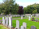 Upload another image
|
| Smiddy And Sseb Substation, 204 Lanark Road West | | | | 55°53′47″N3°18′37″W / 55.896298°N 3.310147°W / 55.896298; -3.310147 (Smiddy And Sseb Substation, 204 Lanark Road West) | Category C(S) | 6121 | |
| 99, 101, Lanark Road West | | | | 55°53′52″N3°18′08″W / 55.89774°N 3.302103°W / 55.89774; -3.302103 (99, 101, Lanark Road West) | Category C(S) | 6123 | |
| 200, 202 And 204 Lanark Road West | | | | 55°53′47″N3°18′37″W / 55.896298°N 3.310147°W / 55.896298; -3.310147 (200, 202 And 204 Lanark Road West) | Category C(S) | 6120 | |
| 209 Lanark Road West | | | | 55°53′45″N3°18′38″W / 55.895879°N 3.310676°W / 55.895879; -3.310676 (209 Lanark Road West) | Category C(S) | 6127 | |
| Rosebery Cottages (Old School, Now Ellenvale And Sycamore Cottage) Including Garden Walls Kirkgate, Currie | | | | 55°53′43″N3°18′31″W / 55.89521°N 3.308495°W / 55.89521; -3.308495 (Rosebery Cottages (Old School, Now Ellenvale And Sycamore Cottage) Including Garden Walls Kirkgate, Currie) | Category B | 6115 |  Upload another image
|
| Currie Farmhouse, Now 1, 2 Easter Currie Court, Lanark Road West | | | | 55°53′48″N3°18′29″W / 55.896536°N 3.308012°W / 55.896536; -3.308012 (Currie Farmhouse, Now 1, 2 Easter Currie Court, Lanark Road West) | Category B | 6117 | |
| Millbank, 33 Lanark Road West | | | | 55°54′00″N3°17′41″W / 55.900126°N 3.294858°W / 55.900126; -3.294858 (Millbank, 33 Lanark Road West) | Category C(S) | 6122 | |
| Union Canal Bridge 9 East Hermiston | | | | 55°55′17″N3°18′30″W / 55.921413°N 3.308418°W / 55.921413; -3.308418 (Union Canal Bridge 9 East Hermiston) | Category C(S) | 6096 | |
| Schoolhouse, Kirkgate, Currie Including Garden Walls | | | | 55°53′43″N3°18′29″W / 55.895342°N 3.307924°W / 55.895342; -3.307924 (Schoolhouse, Kirkgate, Currie Including Garden Walls) | Category C(S) | 6114 | |
| 161-165 (No. 165 Eden Cottage) Lanark Road West | | | | 55°53′48″N3°18′24″W / 55.896552°N 3.306541°W / 55.896552; -3.306541 (161-165 (No. 165 Eden Cottage) Lanark Road West) | Category B | 6126 | |
| Currie Village Currie Parish Church (St Kentigern's) | | | | 55°53′42″N3°18′29″W / 55.895063°N 3.307994°W / 55.895063; -3.307994 (Currie Village Currie Parish Church (St Kentigern's)) | Category A | 6139 | |
| 21-24 (Inclusive Numbers) Braeburn Drive | | | | 55°53′35″N3°17′58″W / 55.893167°N 3.299455°W / 55.893167; -3.299455 (21-24 (Inclusive Numbers) Braeburn Drive) | Category B | 6093 | |
| 194 Lanark Road West | | | | 55°53′48″N3°18′32″W / 55.896554°N 3.308892°W / 55.896554; -3.308892 (194 Lanark Road West) | Category C(S) | 6119 | |
| Kinleith Bridge Water Of Leith | | | | 55°53′59″N3°17′41″W / 55.899605°N 3.294824°W / 55.899605; -3.294824 (Kinleith Bridge Water Of Leith) | Category B | 5706 | 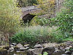 Upload another image
|
| Gibson Craig Memorial Hall, Lanark Road West | | | | 55°53′49″N3°18′22″W / 55.89706°N 3.306094°W / 55.89706; -3.306094 (Gibson Craig Memorial Hall, Lanark Road West) | Category C(S) | 6116 | |