List
| Name | Location | Date Listed | Grid Ref. [note 1] | Geo-coordinates | Notes | LB Number [note 2] | Image |
|---|---|---|---|---|---|---|---|
| 20-24 (Even Nos) Warrender Park Road | 55°56′17″N3°11′33″W / 55.937929°N 3.192443°W | Category B | 30490 | 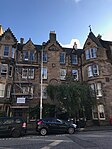 | |||
| 5-9 (Inclusive Nos)Alvanley Terrace | 55°56′16″N3°12′11″W / 55.937755°N 3.202956°W | Category B | 30495 |  Upload Photo | |||
| 27 Lauder Road, Kenneth Mackenzie House With Gatepiers And Boundary Walls | 55°56′05″N3°11′11″W / 55.93478°N 3.186344°W | Category B | 30405 | Upload Photo | |||
| 29 Lauder Road With Conservatory And Gatepiers | 55°56′06″N3°11′11″W / 55.934959°N 3.186461°W | Category B | 30406 | Upload Photo | |||
| 46 Lauder Road | 55°56′13″N3°11′19″W / 55.937058°N 3.188607°W | Category C(S) | 30419 | Upload Photo | |||
| 48 And 48A Lauder Road | 55°56′14″N3°11′19″W / 55.93722°N 3.188644°W | Category C(S) | 30420 | Upload Photo | |||
| 29 Mansionhouse Road, Pepper | 55°56′06″N3°11′21″W / 55.93506°N 3.189042°W | Category B | 30423 | Upload Photo | |||
| 33 Mansionhouse Road | 55°56′05″N3°11′19″W / 55.93473°N 3.188711°W | Category C(S) | 30425 | Upload Photo | |||
| 43 Mansionhouse Road | 55°56′01″N3°11′17″W / 55.933713°N 3.187928°W | Category B | 30427 | Upload Photo | |||
| 32-36 And 38-42 (Even Nos) Marchmont Crescent | 55°56′15″N3°11′34″W / 55.937576°N 3.192753°W | Category B | 30433 |  | |||
| 74-78 Marchmont Crescent | 55°56′12″N3°11′36″W / 55.936661°N 3.193429°W | Category B | 30439 |  | |||
| 77-81 (Odd Nos) Marchmont Road | 55°56′10″N3°11′38″W / 55.936072°N 3.193987°W | Category B | 30443 | 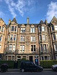 | |||
| 97 Lanark Road, Former Lodge | 55°55′13″N3°15′12″W / 55.920305°N 3.253429°W | Category C(S) | 30321 | Upload Photo | |||
| Albion Place, Lockhart Memorial Church, With Hall, Boundary Walls And Railings | 55°57′42″N3°10′01″W / 55.961733°N 3.16692°W | Category B | 30324 | Upload Photo | |||
| 35-39 (Inclusive Nos) Argyle Place | 55°56′21″N3°11′30″W / 55.939257°N 3.191732°W | Category B | 30340 | 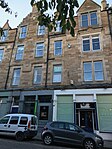 | |||
| 40-43 (Inclusive Nos) Argyle Place | 55°56′22″N3°11′30″W / 55.939427°N 3.191753°W | Category B | 30341 | 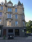 | |||
| 57 Dick Place | 55°55′59″N3°11′31″W / 55.933037°N 3.191925°W | Category C(S) | 30355 | Upload Photo | |||
| 6 Dick Place, St Margaret's Nursing Home | 55°56′04″N3°10′56″W / 55.934362°N 3.182201°W | Category B | 30359 |  | |||
| 38 Dick Place, Grange Park House, Formerly Egremont | 55°55′57″N3°11′22″W / 55.93246°N 3.189346°W | Category A | 30365 | Upload Photo | |||
| 1 And 3 Barnshot Road, With Boundary Wall And Gates | 55°54′23″N3°15′22″W / 55.906349°N 3.256194°W | Category C(S) | 30224 | Upload Photo | |||
| 35-43 (Odd Nos) Causewayside, Garage | 55°56′19″N3°10′53″W / 55.938485°N 3.181318°W | Category B | 30227 |  | |||
| Cowgate, Near The Pleasance, Police Box | 55°56′57″N3°11′02″W / 55.949083°N 3.183771°W | Category B | 30240 |  | |||
| Drumsheugh Gardens At Queensferry Road, Police Box | 55°57′05″N3°12′47″W / 55.951287°N 3.21308°W | Category B | 30242 | Upload Photo | |||
| 13-17 (Odd Nos) Murrayfield Drive, Balnagowan, Including Boundary Walls, Gatepiers And Gates | 55°56′50″N3°14′41″W / 55.947214°N 3.244851°W | Category A | 30251 |  | |||
| Cammo Road, Cammo Estate, Walled Garden, Gate Piers, Out Buildings & Bee- Boles (Off Cammo Walk) | 55°57′20″N3°19′31″W / 55.95563°N 3.3253°W | Category C(S) | 30261 | Upload Photo | |||
| Cammo Road, Cammo Estate, Bridge Including Quadrant Walls, And Estate Boundary Walls | 55°57′35″N3°19′07″W / 55.959673°N 3.318599°W | Category B | 30262 | Upload Photo | |||
| 78 The Pleasance | 55°56′51″N3°10′55″W / 55.947393°N 3.181894°W | Category C(S) | 30144 | Upload Photo | |||
| Roseburn Cliff, 1-3 (Inclusive Nos) George Pape's Widows' Cottages | 55°56′45″N3°14′06″W / 55.945964°N 3.235059°W | Category C(S) | 30152 | Upload Photo | |||
| 28 St Andrew Square With Balustrading, Scottish Equitable | 55°57′19″N3°11′35″W / 55.955176°N 3.192942°W | Category A | 30160 |  | |||
| 89-95 (Odd Nos) Shandwick Place | 55°56′56″N3°12′37″W / 55.948942°N 3.210269°W | Category C(S) | 30178 | Upload Photo | |||
| 22-30 (Even Numbers) Shandwick Place | 55°57′00″N3°12′34″W / 55.949993°N 3.209389°W | Category C(S) | 30181 | Upload Photo | |||
| 30 York Road. Woodbine Cottage, With Boundary Wall | 55°58′43″N3°12′12″W / 55.978636°N 3.203215°W | Category B | 30197 | Upload Photo | |||
| 1A Duddingston Park, Former Janitor`S House | 55°56′56″N3°07′10″W / 55.948812°N 3.119484°W | Category C(S) | 30208 | Upload Photo | |||
| 24 (Heritage Museum) And 25 (Restaurant) Pier Place, Newhaven Fishmarket | 55°58′55″N3°11′41″W / 55.981872°N 3.194821°W | Category B | 30221 | Upload Photo | |||
| Carrington Road, Fettes College, Carrington House | 55°57′43″N3°13′37″W / 55.961994°N 3.227°W | Category B | 30222 | Upload Photo | |||
| Craiglockhart Dell East Grotto | 55°55′09″N3°15′01″W / 55.919159°N 3.250384°W | Category B | 30056 | Upload Photo | |||
| 28 And 30 Broughton Street | 55°57′28″N3°11′22″W / 55.957878°N 3.189549°W | Category B | 30068 | Upload Photo | |||
| Cluny Gardens 1 Royal Bank Of Scotland | 55°55′30″N3°12′32″W / 55.924963°N 3.208993°W | Category B | 30078 | Upload Photo | |||
| 41-45 (Odd Nos) Cockburn Street | 55°57′03″N3°11′22″W / 55.950734°N 3.189554°W | Category B | 30081 | Upload Photo | |||
| 59-63 (Odd Nos) Cockburn Street | 55°57′03″N3°11′20″W / 55.950696°N 3.18888°W | Category B | 30084 | Upload Photo | |||
| 2 And 4 Cockburn Street And 18-21 (Inclusive Nos) Market Street, Including Former Boiler House Adjoining To Rear And Former Printing Works And Offices To E Of Advocate's Close | 55°57′02″N3°11′30″W / 55.950661°N 3.19157°W | Category B | 30085 | Upload Photo | |||
| 42-46 (Even Nos) Cockburn Street | 55°57′02″N3°11′20″W / 55.950461°N 3.189017°W | Category B | 30091 |  | |||
| 48 Cockburn Street | 55°57′01″N3°11′20″W / 55.950373°N 3.188806°W | Category B | 30092 |  | |||
| 50 Cockburn Street | 55°57′01″N3°11′19″W / 55.950375°N 3.188646°W | Category B | 30093 | Upload Photo | |||
| 174 Granton Road And 2 Wardie Crescent, Grantons Including Gatepiers And Boundary Wall | 55°58′41″N3°13′01″W / 55.978053°N 3.216835°W | Category B | 30111 | Upload Photo | |||
| 41-47 (Odd Nos) Lothian Street | 55°56′47″N3°11′21″W / 55.946271°N 3.189241°W | Category B | 30136 | Upload Photo | |||
| 53-55 (Odd Nos) York Place, Including Railings | 55°57′23″N3°11′19″W / 55.956286°N 3.188731°W | Category A | 29971 | Upload Photo | |||
| 5 York Road, With Boundary Wall And Gatepiers | 55°58′35″N3°12′11″W / 55.976418°N 3.203098°W | Category B | 29995 | Upload Photo | |||
| James Craig Walk And Princes Street, General Register House Sasine Office | 55°57′16″N3°11′22″W / 55.95442°N 3.189379°W | Category B | 30026 | Upload Photo | |||
| 18-22 (Even Nos) Greenside Place, The Playhouse Theatre | 55°57′24″N3°11′05″W / 55.956773°N 3.184838°W | Category A | 30029 | 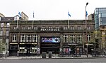 | |||
| 7-8 Chambers Street, Former Police Training School | 55°56′54″N3°11′15″W / 55.94821°N 3.187571°W | Category C(S) | 30030 | Upload Photo | |||
| 1 Lauriston Place, Royal Infirmary Forecourt, Statue Of George Ii | 55°56′41″N3°11′35″W / 55.944662°N 3.193019°W | Category A | 30033 | Upload Photo | |||
| 94-96 (Even Nos) West Bow | 55°56′54″N3°11′40″W / 55.948306°N 3.19438°W | Category B | 29908 | Upload Photo | |||
| 5 West Coates, Including Boundary Walls, Obelisk And Gate Piers | 55°56′46″N3°13′47″W / 55.946054°N 3.229698°W | Category B | 29921 | Upload Photo | |||
| 1 West Harbour Road, Former Bonded Warehouse | 55°58′52″N3°13′31″W / 55.981106°N 3.225185°W | Category B | 29924 | Upload Photo | |||
| 22 West Harbour Road, Northern Lighthouse Board Engineering, Storage And Testing Facility, Including Outhouses | 55°58′54″N3°13′45″W / 55.981741°N 3.229132°W | Category C(S) | 29925 | Upload Photo | |||
| 126 Duddingston Road With Boundary Wall And Railings | 55°56′45″N3°08′07″W / 55.945721°N 3.135167°W | Category B | 29936 |  | |||
| 29 Woodhall Road, Capelaw With Retaining Boundary Wall, Steps, Gate, And Garage | 55°54′22″N3°15′31″W / 55.9061°N 3.258554°W | Category C(S) | 29949 | Upload Photo | |||
| 33 Woodhall Road, Torwood With Boundary Wall And Gate | 55°54′20″N3°15′33″W / 55.905645°N 3.259099°W | Category C(S) | 29950 | Upload Photo | |||
| 6 Woodhall Road With Boundary Wall | 55°54′25″N3°15′28″W / 55.906817°N 3.257905°W | Category C(S) | 29955 | Upload Photo | |||
| 7 York Place, Including Railings | 55°57′21″N3°11′31″W / 55.95578°N 3.191839°W | Category A | 29960 | Upload Photo | |||
| 110-112 (Consecutive Nos) Lower Granton Road, East Cottages | 55°58′48″N3°13′00″W / 55.979969°N 3.216655°W | Category C(S) | 29886 | Upload Photo | |||
| 89 West Bow | 55°56′54″N3°11′41″W / 55.948339°N 3.194765°W | Category A | 29903 | Upload Photo | |||
| 101 And 103 West Bow | 55°56′53″N3°11′41″W / 55.948086°N 3.194853°W | Category A | 29906 | Upload Photo | |||
| Starbank Road, 1 And 2, And 6-8 Craighall Road, Newhaven | 55°58′49″N3°11′54″W / 55.980175°N 3.198359°W | Category B | 29832 | Upload Photo | |||
| 25 And 25A-C Thistle Street And 2 North West Thistle Street Lane | 55°57′15″N3°11′54″W / 55.954244°N 3.198246°W | Category B | 29837 | Upload Photo | |||
| 1 - 5 (Inclusive Nos) Trinity Crescent | 55°58′48″N3°12′21″W / 55.980066°N 3.205872°W | Category C(S) | 29851 | Upload Photo | |||
| 31 And 31A Trinity Crescent With Railings | 55°58′47″N3°12′13″W / 55.979746°N 3.203618°W | Category C(S) | 29856 | Upload Photo | |||
| 70, 72 And 74 Trinity Road, Including Boundary Walls And Gatepiers | 55°58′33″N3°12′27″W / 55.97597°N 3.207523°W | Category C(S) | 29857 | Upload Photo | |||
| 104 Viewforth, Kellyden, Including Boundary Walls | 55°56′20″N3°12′38″W / 55.938947°N 3.210549°W | Category B | 29875 | Upload Photo | |||
| St Leonard's Bank 12 Gibraltar-House | 55°56′34″N3°10′36″W / 55.942826°N 3.176535°W | Category B | 29730 | Upload Photo | |||
| St Patrick Square 24-25 | 55°56′34″N3°11′00″W / 55.942742°N 3.183433°W | Category B | 29736 | Upload Photo | |||
| 6 St Patrick Street And 21 East Crosscauseway | 55°56′37″N3°11′00″W / 55.943741°N 3.183239°W | Category C(S) | 29741 | Upload Photo | |||
| 41-45 (Odd Nos) Salisbury Road, Salisbury Hotel, Including Boundary Walls | 55°56′16″N3°10′38″W / 55.937816°N 3.177119°W | Category B | 29757 | Upload Photo | |||
| 15-19A (Odd Nos) Scotland Street, Including Railings | 55°57′36″N3°11′41″W / 55.959904°N 3.194689°W | Category B | 29774 | Upload Photo | |||
| 25-27A (Odd Nos) Scotland Street, Including Railings | 55°57′37″N3°11′41″W / 55.960145°N 3.194792°W | Category B | 29776 | Upload Photo | |||
| 3 Rustic Cottages With Boundary Wall | 55°54′29″N3°15′11″W / 55.907963°N 3.252999°W | Category B | 29683 | Upload Photo | |||
| 1 Rutland Place, And 1 And 3 Rutland Street, Rutland Hotel And Bar, Including Railings And Lamp Standard | 55°57′00″N3°12′28″W / 55.94991°N 3.207801°W | Category A | 29685 | Upload Photo | |||
| 36 St Andrew Square, Dundas House, Royal Bank Of Scotland Head Office, With Associated Additions, Walls, Gatepiers, Gates, Railings And Lamp Standards | 55°57′16″N3°11′27″W / 55.954567°N 3.190889°W | Category A | 29705 |  | |||
| 4-16 (Even Nos) Roxburgh Street Including Wall And Railings | 55°56′52″N3°11′01″W / 55.947664°N 3.183647°W | Category B | 29676 | Upload Photo | |||
| 125, 127 And 127A Rose Street | 55°57′07″N3°12′08″W / 55.951958°N 3.202323°W | Category B | 29645 | Upload Photo | |||
| 35-37 (Inclusive Nos) Queen Street With Railings | 55°57′16″N3°12′02″W / 55.95432°N 3.200603°W | Category A | 29552 | Upload Photo | |||
| 78 And 78A Queen Street With Railings | 55°57′12″N3°12′24″W / 55.953253°N 3.2068°W | Category A | 29573 | Upload Photo | |||
| 35-41 (Odd Numbers) Raeburn Place | 55°57′32″N3°12′43″W / 55.958854°N 3.212036°W | Category C(S) | 29583 | Upload Photo | |||
| Raeburn Street, 11 And 12 | 55°57′32″N3°12′45″W / 55.958876°N 3.212533°W | Category B | 29592 | Upload Photo | |||
| 3 Ramsay Lane, Former Tolbooth Parish School | 55°56′57″N3°11′45″W / 55.949245°N 3.195802°W | Category C(S) | 29597 |  | |||
| 134 Princes Street, And 1 And 3 South Charlotte Street | 55°57′03″N3°12′20″W / 55.950784°N 3.205682°W | Category B | 29521 | Upload Photo | |||
| 135 And 136 Princes Street And 2-8 (Even Nos) South Charlotte Street, Charlotte House | 55°57′03″N3°12′23″W / 55.950696°N 3.206432°W | Category B | 29522 | Upload Photo | |||
| 142 And 143 Princes Street, Royal Bank Of Scotland | 55°57′02″N3°12′26″W / 55.950508°N 3.207243°W | Category B | 29523 | Upload Photo | |||
| Quality Street 7, 9 Davidson's Mains, Bourtree Bank | 55°57′48″N3°16′24″W / 55.96343°N 3.273262°W | Category B | 29526 | Upload Photo | |||
| 15 Queen Street With Railings | 55°57′18″N3°11′51″W / 55.95489°N 3.197401°W | Category B | 29539 | Upload Photo | |||
| Nicolson Street West 23-33 | 55°56′41″N3°11′07″W / 55.944773°N 3.185272°W | Category C(S) | 29435 | Upload Photo | |||
| Nicolson Street West, 55-57 And 14, 16 Chapel Street | 55°56′40″N3°11′09″W / 55.944498°N 3.18584°W | Category B | 29437 | Upload Photo | |||
| Nicolson Street West, 24-30 | 55°56′41″N3°11′06″W / 55.944596°N 3.184995°W | Category B | 29439 | Upload Photo | |||
| 70 Northumberland Street, Including Railings And Lamp | 55°57′23″N3°12′06″W / 55.956278°N 3.201641°W | Category A | 29459 | Upload Photo | |||
| Old Church Lane, 14, Lochside House, Duddingston | 55°56′30″N3°08′51″W / 55.941635°N 3.147552°W | Category B | 29466 | Upload Photo | |||
| 24-28 (Even Nos) Nelson Street, Including Railings And Lamps | 55°57′28″N3°11′47″W / 55.957685°N 3.196495°W | Category A | 29392 | Upload Photo | |||
| 184 Newhaven Road, Ramsay House, Including Coach House, Gatepiers, Boundary Wall | 55°58′37″N3°11′32″W / 55.976956°N 3.192122°W | Category B | 29397 | Upload Photo | |||
| 232 Newhaven Road, Jessfield House | 55°58′44″N3°11′34″W / 55.978853°N 3.192885°W | Category B | 29402 | Upload Photo | |||
| 37-41 (Odd Nos) Nicolson Street | 55°56′47″N3°11′09″W / 55.946404°N 3.185754°W | Category B | 29416 | Upload Photo | |||
| Nicolson Street, 124-132 | 55°56′39″N3°11′00″W / 55.9441°N 3.183282°W | Category B | 29429 | Upload Photo | |||
| Nicolson Street West, 11-15 | 55°56′42″N3°11′06″W / 55.944947°N 3.184909°W | Category B | 29433 | Upload Photo | |||
| 5 And 7 Middleby Street, Including Boundary Walls And Pedestrian Gates | 55°56′05″N3°10′34″W / 55.934823°N 3.176212°W | Category B | 29332 | Upload Photo | |||
| 3 Minto Street, Including Boundary Walls And Pedestrian Gates | 55°56′14″N3°10′38″W / 55.937087°N 3.177177°W | Category B | 29338 | Upload Photo | |||
| 4 Minto Street, Including Boundary Walls | 55°56′13″N3°10′37″W / 55.936874°N 3.176979°W | Category B | 29339 | Upload Photo | |||
| 1, 2, 3 And 4 Peacock Court | 55°58′50″N3°11′36″W / 55.980486°N 3.193208°W | Category C(S) | 29286 | Upload Photo | |||
| 43-47 (Odd Nos) Newhaven Main Street | 55°58′49″N3°11′51″W / 55.980164°N 3.197621°W | Category C(S) | 29289 | Upload Photo | |||
| 2-4A (Inclusive Nos) West Mayfield And 31 And 31A Minto Street, Including Boundary Walls | 55°56′02″N3°10′29″W / 55.93392°N 3.174776°W | Category B | 29310 | Upload Photo | |||
| 22-26 (Even Nos) Keir Street, Including Boundary Wall And Railings | 55°56′43″N3°11′50″W / 55.945359°N 3.197219°W | Category B | 29201 | Upload Photo | |||
| Lanark Road, 533 Juniper Cottage Juniper Green | 55°54′12″N3°17′06″W / 55.903257°N 3.284965°W | Category C(S) | 29204 | Upload Photo | |||
| Lanark Road, 538 540 Juniper Green | 55°54′13″N3°17′05″W / 55.903663°N 3.284851°W | Category C(S) | 29210 | Upload Photo | |||
| 17-21A (Odd Nos) India Street, Including Railings And Lamps | 55°57′21″N3°12′19″W / 55.955747°N 3.205388°W | Category A | 29129 | Upload Photo | |||
| 12 India Street, Including Railings And Lamp | 55°57′19″N3°12′21″W / 55.955194°N 3.205867°W | Category A | 29132 | Upload Photo | |||
| 18 India Street, Including Railings And Lamp | 55°57′20″N3°12′22″W / 55.955426°N 3.206035°W | Category A | 29135 | Upload Photo | |||
| 32 India Street, Including Railings And Lamp | 55°57′21″N3°12′23″W / 55.955953°N 3.206339°W | Category A | 29138 | Upload Photo | |||
| 34 India Street, Including Railings And Lamp | 55°57′22″N3°12′23″W / 55.956025°N 3.206358°W | Category A | 29139 | Upload Photo | |||
| Inverleith Place 37 | 55°58′03″N3°12′33″W / 55.96757°N 3.209296°W | Category B | 29150 | Upload Photo | |||
| Inverleith Row, 7 | 55°57′54″N3°12′12″W / 55.964879°N 3.203269°W | Category B | 29156 | Upload Photo | |||
| Inverleith Row, 42 And 43 | 55°58′09″N3°12′27″W / 55.969186°N 3.20752°W | Category B | 29177 | Upload Photo | |||
| 25 Johnston Terrace | 55°56′53″N3°11′50″W / 55.94801°N 3.197109°W | Category C(S) | 29195 | Upload Photo | |||
| 12-16 (Even Nos) Hope Street | 55°57′03″N3°12′32″W / 55.950808°N 3.208758°W | Category A | 29094 | Upload Photo | |||
| 19 And 19B Howe Street, And 72-76, (Even Nos) Northumberland Street, Including Railings | 55°57′22″N3°12′07″W / 55.95623°N 3.201943°W | Category A | 29111 | Upload Photo | |||
| 1 And 2 Hunter Square And 124 High Street | 55°57′00″N3°11′18″W / 55.949912°N 3.1882°W | Category B | 29122 | Upload Photo | |||
| 3, 4 And 5 Hunter Square, Dolphin House | 55°56′59″N3°11′18″W / 55.949749°N 3.188339°W | Category A | 29123 |  | |||
| 51-55 (Odd Nos) High Street, Moubray House | 55°57′02″N3°11′07″W / 55.950677°N 3.185228°W | Category A | 29034 |  | |||
| 123 High Street | 55°57′02″N3°11′12″W / 55.950438°N 3.186678°W | Category B | 29040 | Upload Photo | |||
| High Street, 3 Advocate's Close ('Adam Bothwell's House') | 55°57′00″N3°11′30″W / 55.949951°N 3.19158°W | Category A | 29053 | Upload Photo | |||
| 2-8 (Even Nos) High Street | 55°57′02″N3°11′04″W / 55.950506°N 3.184358°W | Category B | 29055 |  | |||
| 142 And 144 High Street | 55°56′59″N3°11′19″W / 55.949799°N 3.188725°W | Category B | 29068 | Upload Photo | |||
| High Street, New Assembly Close, Lord Reid Building | 55°56′58″N3°11′19″W / 55.949531°N 3.188492°W | Category A | 29069 | Upload Photo | |||
| 186 And 188 High Street | 55°56′58″N3°11′22″W / 55.94954°N 3.189517°W | Category B | 29074 | Upload Photo | |||
| Hill Place 1, 2, 2A | 55°56′46″N3°11′04″W / 55.946111°N 3.18448°W | Category C(S) | 29075 | Upload Photo | |||
| Hamilton Place 12-16 | 55°57′29″N3°12′29″W / 55.958102°N 3.20804°W | Category B | 28994 | Upload Photo | |||
| Henderson Row 62-70 | 55°57′36″N3°12′21″W / 55.960055°N 3.205922°W | Category B | 29024 | Upload Photo | |||
| 7 South Gray Street, Including Gatepiers, Boundary Walls And Pedestrian Gate | 55°56′03″N3°10′37″W / 55.934081°N 3.17683°W | Category B | 28947 | Upload Photo | |||
| 23 And 25 Upper Gray Street, Including Boundary Walls | 55°56′10″N3°10′42″W / 55.936089°N 3.178268°W | Category C(S) | 28954 | Upload Photo | |||
| 48-52 (Even Nos) George Street | 55°57′11″N3°11′54″W / 55.953102°N 3.198355°W | Category B | 28869 | Upload Photo | |||
| 32 Gillespie Road, Huntly With Greenhouse, Gatepiers And Boundary Wall | 55°54′28″N3°16′14″W / 55.907908°N 3.270594°W | Category B | 28900 | Upload Photo | |||
| 48 Gilmore Place And 3 Lower Gilmore Place Including Boundary Wall | 55°56′29″N3°12′30″W / 55.941378°N 3.208288°W | Category C(S) | 28916 | Upload Photo | |||
| 89-95 (Odd Nos) Fountainbridge, 1 Thornybauk And 1 Ponton Street | 55°56′39″N3°12′22″W / 55.944221°N 3.206055°W | Category B | 28776 |  | |||
| 52-56 (Even Nos) Frederick Street With Railings | 55°57′13″N3°12′04″W / 55.953748°N 3.201226°W | Category B | 28795 | Upload Photo | |||
| George Square 23 | 55°56′36″N3°11′26″W / 55.94333°N 3.190496°W | Category A | 28816 | 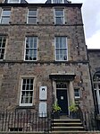 | |||
| George Square 27 | 55°56′35″N3°11′25″W / 55.942937°N 3.190292°W | Category A | 28820 |  | |||
| George Square 29 | 55°56′34″N3°11′25″W / 55.942766°N 3.190238°W | Category A | 28822 |  | |||
| George Square 56 | 55°56′39″N3°11′14″W / 55.944054°N 3.18722°W | Category A | 28824 | Upload Photo | |||
| George Square 57 And 58 | 55°56′39″N3°11′14″W / 55.94417°N 3.187271°W | Category A | 28825 | Upload Photo | |||
| 12-22 (Even Nos) Dundonald Street(Includes 12,19A,19B, And 20B West Scotland Street Lane), Including Railings And Lamps | 55°57′34″N3°11′48″W / 55.959337°N 3.196578°W | Category B | 28726 | Upload Photo | |||
| 30-34 (Even Nos) Elder Street, Including Railings | 55°57′21″N3°11′27″W / 55.955772°N 3.19083°W | Category A | 28731 | Upload Photo | |||
| 142A And 144 Ferry Road And 27, 28 And 29 Summerside Place Including Boundary Wall And Railings | 55°58′28″N3°11′11″W / 55.974432°N 3.186388°W | Category B | 28745 | Upload Photo | |||
| Ferry Road, Former Trinity Cottage, Boundary Walls, Gates And Lodge | 55°58′17″N3°12′33″W / 55.971281°N 3.20922°W | Category C(S) | 28749 | Upload Photo |