List
| Name | Location | Date Listed | Grid Ref. [note 1] | Geo-coordinates | Notes | LB Number [note 2] | Image |
|---|---|---|---|---|---|---|---|
| Orwell Place, Dalry House With Railings And Lamp Standards | 55°56′35″N3°13′08″W / 55.943069°N 3.219004°W | Category B | 26962 |  Upload Photo | |||
| 33 Barony Street, Glasite Meeting House | 55°57′28″N3°11′30″W / 55.957832°N 3.191534°W | Category A | 26973 | 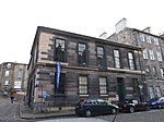 | |||
| 44 Bernard Street | 55°58′34″N3°10′07″W / 55.976166°N 3.168589°W | Category B | 26982 | Upload Photo | |||
| 20 Bellfield Street | 55°57′09″N3°06′29″W / 55.952563°N 3.108158°W | Category C(S) | 26992 | Upload Photo | |||
| 14 Ladycroft | 55°53′03″N3°20′18″W / 55.884205°N 3.33834°W | Category C(S) | 27003 | Upload Photo | |||
| 1 Church Hill, Westgate, With Boundary Walls | 55°55′57″N3°12′31″W / 55.93247°N 3.208603°W | Category B | 27006 | Upload Photo | |||
| Gorgie Road, Gorgie Parish Church (Formerly Up) | 55°56′17″N3°13′59″W / 55.938051°N 3.232982°W | Category B | 26863 | Upload Photo | |||
| 18 Colinton Road | 55°55′56″N3°12′57″W / 55.932155°N 3.215972°W | Category C(S) | 26867 | Upload Photo | |||
| Glenbrook Road, Bankhead House With Walled Garden, Bridge Gates And Railings | 55°52′52″N3°21′20″W / 55.881132°N 3.355548°W | Category B | 26869 | Upload Photo | |||
| Dock Street (Formerly In Johnstone Street), East Gate Of Leith Citadel | 55°58′37″N3°10′29″W / 55.976915°N 3.174845°W | Category B | 26902 | Upload Photo | |||
| 44 Harlaw Road, The Glen, Malleny Mill With Mill Lade And Boundary Wall | 55°52′36″N3°19′31″W / 55.8767°N 3.325231°W | Category C(S) | 26907 | Upload Photo | |||
| 60-66 Bath Street, 25 The Promenade | 55°57′17″N3°06′39″W / 55.954829°N 3.110961°W | Category B | 26908 | Upload Photo | |||
| 24 Canaan Lane, Goshen Bank Or Goshen House | 55°55′39″N3°12′26″W / 55.92763°N 3.207316°W | Category C(S) | 26911 | Upload Photo | |||
| Duddingston Parish Church, Loupin-On-Stane, Old Church Lane, Duddingston | 55°56′29″N3°08′55″W / 55.941345°N 3.148744°W | Category B | 26925 | Upload Photo | |||
| 7 Brunstane Road North, Hamilton Lodge Hotel Including Gatepiers And Boundary Walls | 55°57′04″N3°06′07″W / 55.951162°N 3.102032°W | Category B | 26802 | Upload Photo | |||
| 18 Brunstane Road North, (Rabbit Hall) Including Boundary Walls | 55°57′03″N3°06′04″W / 55.950828°N 3.101142°W | Category B | 26814 | Upload Photo | |||
| 5 Elcho Terrace | 55°57′06″N3°06′19″W / 55.95161°N 3.105168°W | Category C(S) | 26840 | Upload Photo | |||
| Bonnington Sundial | 55°54′24″N3°25′25″W / 55.906755°N 3.423628°W | Category A | 26853 | Upload Photo | |||
| 2 James Street With Boundary Walls | 55°57′02″N3°06′14″W / 55.950614°N 3.103986°W | Category C(S) | 26854 | Upload Photo | |||
| 8 And 10 Colinton Road Napier House With Boundary Walls And Gatepiers | 55°56′01″N3°12′44″W / 55.933638°N 3.212257°W | Category B | 26855 | Upload Photo | |||
| 13, 14 Gladstone Place With Boundary Wall | 55°58′11″N3°09′31″W / 55.969747°N 3.158494°W | Category C(S) | 26856 | Upload Photo | |||
| 39-47 (Odd Nos) Bernard Street | 55°58′33″N3°10′09″W / 55.975964°N 3.169064°W | Category B | 26860 | Upload Photo | |||
| Queensferry Road, Buckingham Terrace And 66 Dean Path, Bristo Baptist Church | 55°57′17″N3°13′17″W / 55.954817°N 3.221391°W | Category B | 26758 | Upload Photo | |||
| 76 Coburg Street, T And Jw Neilson Ltd (Former Stables); Eh6 6Hj | 55°58′33″N3°10′43″W / 55.975775°N 3.17848°W | Category C(S) | 26760 | Upload Photo | |||
| 198-206 Even Nos Bruntsfield Place And 1 And 3 Montpelier Park | 55°56′09″N3°12′36″W / 55.93597°N 3.209976°W | Category B | 26763 | Upload Photo | |||
| George Iv Bridge And 11A And 11C Merchant Street, Augustine United Free Church (United Reformed Church) | 55°56′52″N3°11′28″W / 55.94769°N 3.19119°W | Category B | 26707 | Upload Photo | |||
| 14 Abercorn Terrace St Philip's Parish Church, Including Boundary Walls And Lamp Standards | 55°57′01″N3°06′10″W / 55.950248°N 3.102695°W | Category B | 26724 | Upload Photo | |||
| 6 Claremont Park, Claremont Park Nursing Home With Boundary Wall, Gatepiers And Lamp Brackets | 55°58′11″N3°09′23″W / 55.969775°N 3.156412°W | Category B | 26739 | Upload Photo | |||
| Addistoun Dovecot | 55°54′42″N3°21′17″W / 55.911622°N 3.35466°W | Category A | 26697 |  | |||
| Dalmeny Village, 3 Easter Dalmeny | 55°58′57″N3°22′22″W / 55.982437°N 3.372666°W | Category B | 5529 | Upload Photo | |||
| Dalmeny Village, 9 Main Street, Including Workshop | 55°58′54″N3°22′25″W / 55.981772°N 3.373476°W | Category C(S) | 5537 | Upload Photo | |||
| Dalmeny Village, 9A Main Street, Post Office | 55°58′54″N3°22′25″W / 55.981798°N 3.373557°W | Category C(S) | 5538 | Upload Photo | |||
| Dalmeny Village, 5 Wester Dalmeny Farmhouse, Including Gate, Gatepiers And Boundary Walls | 55°58′57″N3°22′37″W / 55.982363°N 3.37683°W | Category B | 5546 | Upload Photo | |||
| Craigiehall, Stable Court, Including Walls And Gatepiers | 55°57′58″N3°20′11″W / 55.966249°N 3.336269°W | Category B | 5561 | Upload Photo | |||
| Dalmeny House, Home Farm, Including Gatepiers | 55°58′52″N3°19′50″W / 55.981183°N 3.330502°W | Category C(S) | 5499 | Upload Photo | |||
| Dalmeny House, Edinburgh Gate Lodge, Including Gatepiers | 55°58′10″N3°19′24″W / 55.96957°N 3.323261°W | Category B | 5505 | Upload Photo | |||
| Dundas Castle, Ice House | 55°58′19″N3°25′08″W / 55.97193°N 3.418874°W | Category B | 5516 | Upload Photo | |||
| 4 Marine Drive And 11 West Shore Road, Granton Gasworks No 1 Gasholder | 55°58′49″N3°14′41″W / 55.9804°N 3.244587°W | Category B | 45793 | Upload Photo | |||
| 22 Frogston Road West, Including Garage | 55°53′59″N3°11′59″W / 55.899688°N 3.199682°W | Category C(S) | 45838 | Upload Photo | |||
| 12 Swanston Village | 55°53′32″N3°13′02″W / 55.89223°N 3.217089°W | Category B | 45847 |  | |||
| 15 Swanston Village | 55°53′33″N3°13′00″W / 55.892423°N 3.216616°W | Category C(S) | 45849 | Upload Photo | |||
| 105-109 (Odd Nos) Broughton Street | 55°57′32″N3°11′24″W / 55.958951°N 3.190078°W | Category C(S) | 45934 | Upload Photo | |||
| 9 Randolph Place | 55°57′06″N3°12′36″W / 55.951551°N 3.209934°W | Category B | 46123 |  | |||
| 63 Bonaly Road, Druim With, Gates And Garden Terrace | 55°53′52″N3°15′22″W / 55.897686°N 3.256234°W | Category B | 46286 | Upload Photo | |||
| East Trinity Road, Railway Tunnel | 55°58′34″N3°12′12″W / 55.976093°N 3.203297°W | Category B | 46729 | Upload Photo | |||
| Harewood Road, Craigmillar Primary School | 55°56′07″N3°07′53″W / 55.935333°N 3.131437°W | Category B | 46973 | Upload Photo | |||
| 21-35 (Odd Nos) Lauriston Place Including Boundary Walls And Railings | 55°56′41″N3°11′44″W / 55.944728°N 3.195551°W | Category B | 47034 |  | |||
| Fair-A-Far Weir, And Mill Remains | 55°58′26″N3°18′30″W / 55.973801°N 3.308215°W | Category B | 47281 | Upload Photo | |||
| 19 George Square | 55°56′37″N3°11′26″W / 55.943706°N 3.190668°W | Category A | 47583 | 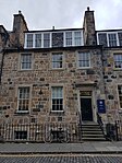 | |||
| 183, 185 And 187 Morrison Street | 55°56′46″N3°12′48″W / 55.946018°N 3.213412°W | Category C(S) | 47726 | Upload Photo | |||
| 30, 31 And 32 Castle Terrace, Including Boundary Wall And Railings | 55°56′49″N3°12′09″W / 55.947077°N 3.20254°W | Category A | 47855 | 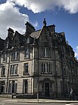 | |||
| 11-15 Cornwall Street, Including Boundary Wall And Railings | 55°56′50″N3°12′12″W / 55.947122°N 3.203455°W | Category A | 47858 | Upload Photo | |||
| Grassmarket, Covenanters' Memorial, With Boundary Wall, Railings And Gate | 55°56′52″N3°11′41″W / 55.947837°N 3.194638°W | Category C(S) | 47867 | Upload Photo | |||
| 26 And 28 Lauriston Place, Including Boundary Walls, Railings And Gate | 55°56′42″N3°11′47″W / 55.945132°N 3.196444°W | Category B | 47889 | 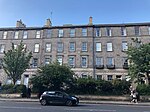 | |||
| 9-15 (Odd Nos) Spittal Street | 55°56′46″N3°12′13″W / 55.946249°N 3.203556°W | Category C(S) | 47897 | Upload Photo | |||
| 2-10 (Even Nos) Spittal Street And 39-45 (Odd Nos) Bread Street | 55°56′45″N3°12′11″W / 55.945948°N 3.20313°W | Category C(S) | 47900 | Upload Photo | |||
| 6 Douglas Gardens, Belford Road, Former Belford Church | 55°57′03″N3°13′13″W / 55.950918°N 3.220404°W | Category B | 48133 |  | |||
| Edinburgh Castle, Lang Stairs | 55°56′56″N3°12′00″W / 55.948944°N 3.200004°W | Category B | 48221 | Upload Photo | |||
| 83 London Road, Holyrood Abbey Church (Church Of Scotland) | 55°57′25″N3°10′09″W / 55.957048°N 3.169214°W | Category B | 48539 | Upload Photo | |||
| Henderland Road, St George's School, Lansdowne House Including Gatehouse, Gatepiers And Boundary Wall | 55°56′54″N3°14′08″W / 55.948215°N 3.235515°W | Category C(S) | 48889 | Upload Photo | |||
| 23 Murrayfield Road, Redcroft, With Boundary Wall | 55°56′52″N3°14′52″W / 55.947894°N 3.247803°W | Category C(S) | 48899 | Upload Photo | |||
| 43 Murrayfield Road, Clubhouse, Including Boundary Wall And Gatepiers | 55°57′00″N3°15′04″W / 55.94998°N 3.251169°W | Category C(S) | 48900 | Upload Photo | |||
| 29-39 (Odd Numbers) Montrose Terrace | 55°57′26″N3°10′16″W / 55.957174°N 3.171076°W | Category B | 49060 | Upload Photo | |||
| 41-49 (Odd Numbers) Montrose Terrace | 55°57′26″N3°10′14″W / 55.957259°N 3.170662°W | Category B | 49061 | Upload Photo | |||
| 70 Kingston Avenue, Kingston Stables With Boundary Wall, Gatepiers And Entrance Arch | 55°55′11″N3°08′58″W / 55.919856°N 3.14934°W | Category B | 49539 | Upload Photo | |||
| 13 Kinnear Road, Jeffrey House With Boundary Wall And Gateposts | 55°58′04″N3°13′05″W / 55.967806°N 3.218132°W | Category B | 49543 | Upload Photo | |||
| 71 Bonaly Road, Lord Cockburn's Bath And "Ruined Chapel" | 55°53′39″N3°15′41″W / 55.894291°N 3.261354°W | Category B | 49549 | Upload Photo | |||
| 23 And 24 Bridge Road With Raised Pavement And Boundary Wall | 55°54′26″N3°15′31″W / 55.907187°N 3.258573°W | Category C(S) | 49551 | Upload Photo | |||
| 9 Carlton Terrace Including Railings And Boundary Walls | 55°57′23″N3°10′25″W / 55.956359°N 3.173614°W | Category A | 49751 | Upload Photo | |||
| 19 Carlton Terrace Including Railings And Boundary Walls | 55°57′24″N3°10′30″W / 55.956598°N 3.174983°W | Category A | 49761 |  | |||
| 11 Regent Terrace, Including Railings And Boundary Walls | 55°57′17″N3°10′37″W / 55.954628°N 3.177053°W | Category A | 49774 |  | |||
| 26 Regent Terrace, Including Railings And Boundary Walls | 55°57′19″N3°10′31″W / 55.955327°N 3.175344°W | Category A | 49791 |  | |||
| 27 Regent Terrace, Including Railings And Boundary Walls | 55°57′19″N3°10′31″W / 55.955374°N 3.175218°W | Category A | 49792 |  | |||
| 34 Regent Terrace Including Railings And Boundary Walls | 55°57′21″N3°10′28″W / 55.955704°N 3.174443°W | Category A | 49799 | Upload Photo | |||
| 6 Royal Terrace Including Railings And Boundary Walls | 55°57′24″N3°10′49″W / 55.956736°N 3.180272°W | Category A | 49804 | Upload Photo | |||
| 25 Royal Terrace Including Railings And Boundary Walls | 55°57′24″N3°10′40″W / 55.956662°N 3.177643°W | Category A | 49816 |  | |||
| 30 Royal Terrace Including Railings And Boundary Walls | 55°57′24″N3°10′37″W / 55.956651°N 3.176906°W | Category A | 49821 | Upload Photo | |||
| 35 Royal Terrace Including Railings And Boundary Walls | 55°57′24″N3°10′34″W / 55.956614°N 3.17612°W | Category A | 49827 |  | |||
| 38 Royal Terrace Including Railings And Boundary Walls | 55°57′24″N3°10′32″W / 55.956618°N 3.17564°W | Category A | 49830 |  | |||
| 14 And 16 Holyrood Road | 55°56′57″N3°10′57″W / 55.949122°N 3.182443°W | Category C(S) | 50148 | Upload Photo | |||
| Charterhall Road, Police Box | 55°55′34″N3°11′34″W / 55.925993°N 3.192797°W | Category B | 50880 | Upload Photo | |||
| 70 Belford Road, Former Dean Cemetery Gate Lodge, Including Boundary Walls And Gates | 55°57′03″N3°13′22″W / 55.950913°N 3.22271°W | Category C(S) | 51393 |  | |||
| South Trinity Road, Lamp Standard | 55°58′17″N3°12′28″W / 55.971313°N 3.207779°W | Category B | 51550 | Upload Photo | |||
| 496 Ferry Road, Former Wardieburn House | 55°58′12″N3°13′32″W / 55.969871°N 3.225583°W | Category C(S) | 45650 | Upload Photo | |||
| 1 Lufra Bank, Off Granton View, Lufra House Including Boundary Wall | 55°58′44″N3°13′06″W / 55.979017°N 3.218404°W | Category C(S) | 45657 | Upload Photo | |||
| Queen Street Gardens, Railings And Gates | 55°57′19″N3°12′01″W / 55.955187°N 3.200165°W | Category B | 45519 |  | |||
| Gilmore Park And Fountainbridge, Former North British Rubber Company Ltd | 55°56′32″N3°12′46″W / 55.942115°N 3.212842°W | Category C(S) | 44936 | Upload Photo | |||
| 134 Corstorphine Road, Edinburgh Zoo (Royal Zoological Society Of Scotland) Lodge, Gates And Gatepiers | 55°56′32″N3°16′10″W / 55.942165°N 3.269346°W | Category B | 44749 |  | |||
| East Suffolk Road, St Margaret's School (Former Craigmillar Park Free Church), Including Gatepiers And Boundary Walls | 55°55′48″N3°10′05″W / 55.930083°N 3.168194°W | Category B | 44214 | Upload Photo | |||
| 21 Hallhead Road, Rankine House, Including Gates, Gatepiers And Boundary Walls | 55°55′25″N3°10′15″W / 55.923589°N 3.170799°W | Category B | 44223 | Upload Photo | |||
| 1 Mayfield Terrace, Including Boundary Walls | 55°56′06″N3°10′22″W / 55.935044°N 3.172825°W | Category C(S) | 44231 | Upload Photo | |||
| 12 And 12A Grove Street, Including Railings | 55°56′44″N3°12′47″W / 55.945483°N 3.212963°W | Category B | 44037 | Upload Photo | |||
| 2 Inveralmond Drive | 55°58′13″N3°18′29″W / 55.970407°N 3.308052°W | Category C(S) | 43940 | Upload Photo | |||
| 13 And 15 Park Road, Newhaven, Including Boundary Wall | 55°58′45″N3°11′42″W / 55.979175°N 3.194947°W | Category C(S) | 43719 | Upload Photo | |||
| 15 Hill Street | 55°57′13″N3°12′10″W / 55.953509°N 3.202644°W | Category A | 43298 | Upload Photo | |||
| 36 North West Thistle Street Lane | 55°57′15″N3°12′02″W / 55.954096°N 3.2005°W | Category C(S) | 43311 | Upload Photo | |||
| 76 And 77 Princes Street And 1 Hanover Street | 55°57′08″N3°11′47″W / 55.952295°N 3.196328°W | Category B | 43319 | Upload Photo | |||
| Rose Street, Charlotte Street Baptist Chapel | 55°57′04″N3°12′20″W / 55.951109°N 3.205532°W | Category B | 43329 | Upload Photo | |||
| 162 Rose Street | 55°57′06″N3°12′09″W / 55.951695°N 3.202572°W | Category C(S) | 43339 | Upload Photo | |||
| 194 Rose Street | 55°57′05″N3°12′17″W / 55.951376°N 3.204852°W | Category B | 43343 | Upload Photo | |||
| 131 And 133 Rose Street South Lane | 55°57′04″N3°12′15″W / 55.951238°N 3.204255°W | Category C(S) | 43347 | Upload Photo | |||
| 9 And 10 St Andrew Square | 55°57′12″N3°11′39″W / 55.953447°N 3.194298°W | Category A | 43349 | Upload Photo | |||
| 47A And 49 Thistle Street And 21 North West Thistle Street Lane | 55°57′15″N3°11′58″W / 55.954052°N 3.199538°W | Category B | 43359 | Upload Photo | |||
| 59 And 61 Thistle Street | 55°57′14″N3°12′00″W / 55.953977°N 3.199872°W | Category B | 43361 | Upload Photo | |||
| 50-52 (Even Nos) Thistle Street | 55°57′14″N3°11′57″W / 55.953893°N 3.199276°W | Category B | 43363 | Upload Photo | |||
| 15 Young Street And 24 Young Street Lane North | 55°57′11″N3°12′20″W / 55.953004°N 3.205591°W | Category A | 43366 | Upload Photo | |||
| Alnwickhill Road And 1-4B (Inclusive Nos) Stanedykehead, Alnwickhill House With Gatepiers And Boundary Walls | 55°54′32″N3°10′09″W / 55.908905°N 3.169044°W | Category B | 43233 | Upload Photo | |||
| 74 Liberton Gardens, Alnwickhill Reservoir, Former Superintendent's House With Gates And Gatepiers | 55°54′21″N3°09′57″W / 55.9058°N 3.165864°W | Category C(S) | 43247 | Upload Photo | |||
| Gilmerton, 83 Drum Street | 55°54′17″N3°07′50″W / 55.904845°N 3.130501°W | Category C(S) | 43257 | Upload Photo | |||
| Gilmerton, 89 Ravenscroft Street | 55°54′07″N3°08′10″W / 55.902035°N 3.136034°W | Category C(S) | 43261 | Upload Photo | |||
| Newhaven Road, Victoria Park, Edward Vii Statue, Gatepiers And Quadrant Railings | 55°58′31″N3°11′27″W / 55.975332°N 3.190934°W | Category B | 43279 | Upload Photo | |||
| 25-29 (Odd Nos) And 29A Castle Street | 55°57′08″N3°12′11″W / 55.952132°N 3.202921°W | Category B | 43281 | Upload Photo | |||
| 48, 48A Frederick Street | 55°57′13″N3°12′04″W / 55.953479°N 3.201153°W | Category B | 43284 | Upload Photo | |||
| 297 Dalkeith Road, Including Gatepiers | 55°55′51″N3°09′46″W / 55.930889°N 3.162824°W | Category C(S) | 43150 | Upload Photo | |||
| 7 Upper Gray Street, St Columba's Rc Church Including Boundary Walls | 55°56′12″N3°10′43″W / 55.936669°N 3.178605°W | Category B | 43173 |  | |||
| 44 And 45 Water Street | 55°58′28″N3°10′11″W / 55.974377°N 3.169673°W | Category B | 43176 | Upload Photo | |||
| 8 High Street And 1 Gote Lane, Stag Head Hotel | 55°59′26″N3°23′49″W / 55.99053°N 3.396935°W | Category B | 40375 | Upload Photo | |||
| 29/1 - 29/4 And 29/7 Hopetoun Road And 5 And 6 The Loan, Plewlands House | 55°59′26″N3°23′52″W / 55.990537°N 3.397882°W | Category A | 40389 |  | |||
| 2 Hopetoun Road, 4 Bellstane | 55°59′27″N3°23′51″W / 55.990746°N 3.397617°W | Category B | 40390 | Upload Photo | |||
| Hopetoun Road, Inchgarvie House (Flats A-L) | 55°59′32″N3°25′17″W / 55.9922°N 3.421396°W | Category C(S) | 40392 | Upload Photo | |||
| 1 Mid Terrace | 55°59′23″N3°23′43″W / 55.989784°N 3.39537°W | Category B | 40395 | Upload Photo | |||
| 1-6 (Inclusive Numbers) Mid Terrace, Wall And Railings | 55°59′24″N3°23′44″W / 55.98988°N 3.395581°W | Category B | 40399 | Upload Photo | |||
| Stoneycroft Road From The Loan To Rear Of 11 East Terrace, Railway Embankment | 55°59′20″N3°23′42″W / 55.988907°N 3.395049°W | Category C(S) | 40400 | Upload Photo | |||
| 40 Shore Road, Flotilla Club, (Now Sheltered Accommodation) | 55°59′30″N3°24′10″W / 55.991686°N 3.402733°W | Category B | 40412 | Upload Photo | |||
| 10A And 10B East Terrace | 55°59′22″N3°23′37″W / 55.98957°N 3.393566°W | Category B | 40341 | Upload Photo | |||
| 16 East Terrace And Camperdown | 55°59′23″N3°23′40″W / 55.989596°N 3.394433°W | Category B | 40346 | Upload Photo | |||
| 17 East Terrace, Inchcolm (In Close To Rear Of 18 East Terrace) | 55°59′22″N3°23′41″W / 55.989505°N 3.39459°W | Category B | 40349 | Upload Photo | |||
| 2 Newhalls Road, Hawes Inn | 55°59′25″N3°23′06″W / 55.99035°N 3.385002°W | Category B | 40354 | Upload Photo | |||
| 2 And 3 Newhalls Road, The Two Bridges Hotel | 55°59′23″N3°23′15″W / 55.989737°N 3.387561°W | Category B | 40357 | Upload Photo | |||
| 1 And 3 Edinburgh Road | 55°59′23″N3°23′34″W / 55.989857°N 3.392807°W | Category C(S) | 40358 | Upload Photo | |||
| 23 Edinburgh Road, Seals Craig Hotel | 55°59′24″N3°23′32″W / 55.989909°N 3.3922°W | Category C(S) | 40362 |  | |||
| Forth Bridge | 55°59′54″N3°23′15″W / 55.998399°N 3.387599°W | Category A | 40370 |  | |||
| 27 South Oswald Road Carrington House Including Gatepiers And Gates | 55°55′42″N3°11′41″W / 55.928265°N 3.194771°W | Category B | 30591 | Upload Photo | |||
| 12-14 (Inclusive Nos) Warrender Park Crescent | 55°56′18″N3°12′06″W / 55.938271°N 3.201579°W | Category B | 30612 | Upload Photo | |||
| 61-63 (Odd Nos) Warrender Park Road | 55°56′19″N3°11′48″W / 55.938617°N 3.196563°W | Category B | 30623 | Upload Photo | |||
| 65 Warrender Park Road | 55°56′19″N3°11′49″W / 55.938605°N 3.196867°W | Category B | 30624 | Upload Photo | |||
| 141-145 (Odd Nos) Warrender Park Road | 55°56′15″N3°12′07″W / 55.93763°N 3.201928°W | Category B | 30639 | Upload Photo | |||
| 25-26 Warrender Park Terrace And 1 Spottiswoode Street | 55°56′21″N3°11′54″W / 55.939111°N 3.198435°W | Category B | 30653 |  | |||
| 33-35 (Inclusive Nos) Warrender Park Terrace | 55°56′20″N3°11′58″W / 55.938912°N 3.199422°W | Category B | 30657 |  | |||
| 10 Greenhill Gardens | 55°56′08″N3°12′19″W / 55.935628°N 3.205387°W | Category B | 30514 | Upload Photo | |||
| 43 Marchmont Crescent | 55°56′14″N3°11′38″W / 55.937143°N 3.19378°W | Category B | 30537 | Upload Photo | |||
| Marchmont Rd & Marchmont Cres Napier Univ Annexe Formerly Marchmont Road School | 55°56′13″N3°11′39″W / 55.936816°N 3.194202°W | Category B | 30538 |  | |||
| 11 Marchmont Road | 55°56′21″N3°11′41″W / 55.939219°N 3.194692°W | Category B | 30540 | Upload Photo | |||
| 59 Marchmont Road | 55°56′14″N3°11′39″W / 55.937166°N 3.194245°W | Category B | 30550 | Upload Photo | |||
| 52-56 (Even Nos) Marchmont Road | 55°56′15″N3°11′42″W / 55.937616°N 3.195107°W | Category B | 30560 | Upload Photo | |||
| 9 Marchmont Street | 55°56′18″N3°12′01″W / 55.938365°N 3.200237°W | Category B | 30573 | Upload Photo | |||
| 23 Mortonhall Road Including Boundary Walls And Steps | 55°55′39″N3°11′31″W / 55.927384°N 3.192023°W | Category B | 30576 | Upload Photo | |||
| 33 Mortonhall Road With Lamp Posts Boundary Walls And Gates And Railings | 55°55′38″N3°11′40″W / 55.927226°N 3.194435°W | Category A | 30578 | Upload Photo | |||
| 2 Roseneath Terrace And 28-30 (Inclusive Nos) Argyle Place | 55°56′19″N3°11′30″W / 55.938745°N 3.191716°W | Category B | 30468 |  | |||
| 4-8 (Even Nos) Roseneath Terrace | 55°56′19″N3°11′31″W / 55.938733°N 3.191956°W | Category B | 30469 |  |