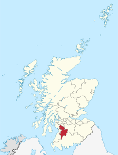
| Name | Location | Date Listed | Grid Ref. [note 1] | Geo-coordinates | Notes | LB Number [note 2] | Image |
|---|
|
| R.C. Church Of St. Sophia | | | | 55°35′57″N4°22′40″W / 55.599116°N 4.377734°W / 55.599116; -4.377734 (R.C. Church Of St. Sophia) | Category A | 32010 |  Upload another image
See more images |
| Barr Tower | | | | 55°35′54″N4°22′47″W / 55.598457°N 4.379741°W / 55.598457; -4.379741 (Barr Tower) | Category B | 32012 |  |
| Portland Arms Hotel | | | | 55°36′02″N4°22′54″W / 55.600515°N 4.381597°W / 55.600515; -4.381597 (Portland Arms Hotel) | Category B | 32014 | |
| Nos. 4-24 (Even Numbers) Polworth Street | | | | 55°36′03″N4°22′48″W / 55.600708°N 4.380037°W / 55.600708; -4.380037 (Nos. 4-24 (Even Numbers) Polworth Street) | Category C(S) | 32018 | |
| Lodge, Lanfine (Opposite The Green) | | | | 55°36′20″N4°19′13″W / 55.605689°N 4.320387°W / 55.605689; -4.320387 (Lodge, Lanfine (Opposite The Green)) | Category B | 13827 | |
| Row Of Cottages, Priestland - (Pal Myra) (Roseside) (Lynedoch) | | | | 55°36′34″N4°15′33″W / 55.60944°N 4.259143°W / 55.60944; -4.259143 (Row Of Cottages, Priestland - (Pal Myra) (Roseside) (Lynedoch)) | Category C(S) | 12570 | |
| 34 Wallace Street With Boundary Wall And Gatepiers | | | | 55°35′57″N4°22′46″W / 55.599163°N 4.379514°W / 55.599163; -4.379514 (34 Wallace Street With Boundary Wall And Gatepiers) | Category B | 48208 | |
| Nos. 33 And 35 Bridge Street (Hugh H. Neil, Grocer) | | | | 55°36′01″N4°22′48″W / 55.600296°N 4.379932°W / 55.600296; -4.379932 (Nos. 33 And 35 Bridge Street (Hugh H. Neil, Grocer)) | Category C(S) | 32017 | |
| Greenbank | | | | 55°36′28″N4°16′00″W / 55.60782°N 4.26656°W / 55.60782; -4.26656 (Greenbank) | Category C(S) | 12571 | |
| Avon Bridge | | | | 55°36′01″N4°11′42″W / 55.600268°N 4.195087°W / 55.600268; -4.195087 (Avon Bridge) | Category B | 12572 | |
| Old Galston Church And Graveyard | | | | 55°36′03″N4°22′56″W / 55.600719°N 4.382244°W / 55.600719; -4.382244 (Old Galston Church And Graveyard) | Category B | 32009 | 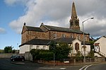 Upload another image
|
| Parkeston Farm | | | | 55°35′54″N4°19′06″W / 55.598278°N 4.318282°W / 55.598278; -4.318282 (Parkeston Farm) | Category C(S) | 12569 | |
| Allanton | | | | 55°36′33″N4°13′22″W / 55.609152°N 4.222782°W / 55.609152; -4.222782 (Allanton) | Category C(S) | 12573 | |
| Glebe Road, Galston Primary School Main Block, Including Gates, Gatepiers, Railings And Boundary Walls | | | | 55°35′53″N4°22′55″W / 55.598045°N 4.382002°W / 55.598045; -4.382002 (Glebe Road, Galston Primary School Main Block, Including Gates, Gatepiers, Railings And Boundary Walls) | Category B | 44603 | |
| Nos. 14-28 (Even Numbers) Titchfield Street | | | | 55°36′05″N4°23′01″W / 55.601503°N 4.383482°W / 55.601503; -4.383482 (Nos. 14-28 (Even Numbers) Titchfield Street) | Category C(S) | 32019 | |
| U.F. Church Wallace Street | | | | 55°35′56″N4°22′49″W / 55.599022°N 4.3803°W / 55.599022; -4.3803 (U.F. Church Wallace Street) | Category B | 32011 | |
| Lanfine Estate, Walled Garden With Former Potting Sheds | | | | 55°36′05″N4°17′35″W / 55.601296°N 4.293076°W / 55.601296; -4.293076 (Lanfine Estate, Walled Garden With Former Potting Sheds) | Category C(S) | 50120 | |
| Galston Bridge | | | | 55°36′06″N4°22′48″W / 55.601565°N 4.379866°W / 55.601565; -4.379866 (Galston Bridge) | Category B | 32013 | |
| R.A. Hutchison & Co | | | | 55°36′02″N4°22′53″W / 55.600512°N 4.381311°W / 55.600512; -4.381311 (R.A. Hutchison & Co) | Category B | 32015 | |
| Lanfine House | | | | 55°36′04″N4°18′05″W / 55.601059°N 4.301397°W / 55.601059; -4.301397 (Lanfine House) | Category B | 13826 | |
| Dovecote, Lanfine Policies | | | | 55°36′03″N4°18′09″W / 55.600938°N 4.302596°W / 55.600938; -4.302596 (Dovecote, Lanfine Policies) | Category B | 12564 | |
| Bridge, In Lanfine Park | | | | 55°36′03″N4°17′51″W / 55.600914°N 4.29761°W / 55.600914; -4.29761 (Bridge, In Lanfine Park) | Category B | 12565 | |
| Burnhead | | | | 55°35′52″N4°13′01″W / 55.597733°N 4.217041°W / 55.597733; -4.217041 (Burnhead) | Category C(S) | 12574 | |
| Glebe Road (East Side), Galston Primary School Infant Block, Including Gates, Gatepiers, Boundary Walls & Railings | | | | 55°35′54″N4°22′52″W / 55.598387°N 4.381023°W / 55.598387; -4.381023 (Glebe Road (East Side), Galston Primary School Infant Block, Including Gates, Gatepiers, Boundary Walls & Railings) | Category C(S) | 49189 | |
| Co-Operative Society Building, 4-12 (Even Nos) Brewland Street | | | | 55°36′01″N4°22′55″W / 55.600265°N 4.381978°W / 55.600265; -4.381978 (Co-Operative Society Building, 4-12 (Even Nos) Brewland Street) | Category B | 32020 | |
| Nos. 4 & 6 Bridge Street | | | | 55°36′02″N4°22′52″W / 55.600488°N 4.38115°W / 55.600488; -4.38115 (Nos. 4 & 6 Bridge Street) | Category C(S) | 32016 | |
| Lodge, Lanfine (Opposite Townhead) | | | | 55°36′18″N4°18′42″W / 55.604975°N 4.311565°W / 55.604975; -4.311565 (Lodge, Lanfine (Opposite Townhead)) | Category B | 12567 | |
| Bruntwood | | | | 55°33′54″N4°22′21″W / 55.564944°N 4.372623°W / 55.564944; -4.372623 (Bruntwood) | Category B | 12575 | |
| Cairnhill Farm | | | | 55°34′42″N4°20′15″W / 55.578454°N 4.337485°W / 55.578454; -4.337485 (Cairnhill Farm) | Category C(S) | 12576 | |
| Holmes House Steading, Horse Engine House | | | | 55°35′55″N4°25′07″W / 55.598479°N 4.418556°W / 55.598479; -4.418556 (Holmes House Steading, Horse Engine House) | Category C(S) | 49579 | |
| Bridge, Greenbank | | | | 55°36′30″N4°15′42″W / 55.608217°N 4.261597°W / 55.608217; -4.261597 (Bridge, Greenbank) | Category C(S) | 13828 | |
| Cessnock Castle | | | | 55°35′26″N4°21′53″W / 55.590445°N 4.364639°W / 55.590445; -4.364639 (Cessnock Castle) | Category A | 12562 | |
| Gateway, Causeyfoot | | | | 55°35′31″N4°22′05″W / 55.59186°N 4.368137°W / 55.59186; -4.368137 (Gateway, Causeyfoot) | Category B | 12563 | |
| Lodge, Lanfine (Opposite Ranoldcoup Bridge) | | | | 55°36′20″N4°16′54″W / 55.605641°N 4.281803°W / 55.605641; -4.281803 (Lodge, Lanfine (Opposite Ranoldcoup Bridge)) | Category B | 12566 | |
| Waterhaughs | | | | 55°36′20″N4°17′32″W / 55.605633°N 4.292313°W / 55.605633; -4.292313 (Waterhaughs) | Category B | 12568 | |
| Sornhill Farm | | | | 55°34′41″N4°21′57″W / 55.578046°N 4.365766°W / 55.578046; -4.365766 (Sornhill Farm) | Category A | 13829 | |