| Name | Location | Date Listed | Grid Ref. [note 1] | Geo-coordinates | Notes | LB Number [note 2] | Image |
|---|
|
| 45 Inveresk Village, Shepherd House With Retaining Walls, Gatepiers And Gates | | | | 55°56′06″N3°02′34″W / 55.934946°N 3.042904°W / 55.934946; -3.042904 (45 Inveresk Village, Shepherd House With Retaining Walls, Gatepiers And Gates) | Category B | 10932 |  |
| 24 Inveresk Village, Inveresk Lodge With Sundial, Former Outbuilding, Retaining And Terrace Walls | | | | 55°56′06″N3°02′38″W / 55.934992°N 3.043786°W / 55.934992; -3.043786 (24 Inveresk Village, Inveresk Lodge With Sundial, Former Outbuilding, Retaining And Terrace Walls) | Category A | 10938 |  Upload another image
See more images |
| Inveresk Village, Crookston Road, Pinkiehill House With Quadrants, Gates And Railings | | | | 55°56′03″N3°02′26″W / 55.934291°N 3.040597°W / 55.934291; -3.040597 (Inveresk Village, Crookston Road, Pinkiehill House With Quadrants, Gates And Railings) | Category B | 10939 | |
| Carberry Tower, Game Larder | | | | 55°54′59″N3°01′14″W / 55.916391°N 3.020422°W / 55.916391; -3.020422 (Carberry Tower, Game Larder) | Category B | 10870 | |
| Carberry Tower Stables (Elphinstone Wing) | | | | 55°55′00″N3°01′07″W / 55.916675°N 3.018669°W / 55.916675; -3.018669 (Carberry Tower Stables (Elphinstone Wing)) | Category B | 10874 | |
| Chalkieside Farmhouse | | | | 55°54′23″N3°00′43″W / 55.906361°N 3.012016°W / 55.906361; -3.012016 (Chalkieside Farmhouse) | Category C(S) | 10876 | |
| Cowpits, The Old Schoolhouse With Retaining Wall | | | | 55°55′33″N3°02′32″W / 55.925914°N 3.042085°W / 55.925914; -3.042085 (Cowpits, The Old Schoolhouse With Retaining Wall) | Category B | 10877 | |
| 3 Inveresk Village, Inveresk House And Linden House With Garden Walls, Gatepiers And Gateway | | | | 55°56′15″N3°02′56″W / 55.937457°N 3.048767°W / 55.937457; -3.048767 (3 Inveresk Village, Inveresk House And Linden House With Garden Walls, Gatepiers And Gateway) | Category B | 10881 | |
| Inveresk Village, Eskhill Lodge With Gatepiers | | | | 55°56′12″N3°02′43″W / 55.936776°N 3.045322°W / 55.936776; -3.045322 (Inveresk Village, Eskhill Lodge With Gatepiers) | Category B | 10885 | |
| Newhailes House, Gardener's Cottage | | | | 55°56′24″N3°04′55″W / 55.939865°N 3.082036°W / 55.939865; -3.082036 (Newhailes House, Gardener's Cottage) | Category C(S) | 10914 | |
| Newhailes House, Stables | | | | 55°56′24″N3°04′53″W / 55.940051°N 3.081304°W / 55.940051; -3.081304 (Newhailes House, Stables) | Category A | 10916 | |
| Smeaton, Shepherd's Cottage, Stable Court | | | | 55°55′09″N3°03′20″W / 55.919276°N 3.055508°W / 55.919276; -3.055508 (Smeaton, Shepherd's Cottage, Stable Court) | Category C(S) | 10926 | |
| 25 Inveresk Village, Rose Court With Garden Walls And Gate | | | | 55°56′10″N3°02′39″W / 55.936031°N 3.044198°W / 55.936031; -3.044198 (25 Inveresk Village, Rose Court With Garden Walls And Gate) | Category B | 10930 | |
| 14 Inveresk Village, Oak Lodge With Terrace And Retaining Walls And Gatepiers | | | | 55°56′11″N3°02′46″W / 55.936509°N 3.046116°W / 55.936509; -3.046116 (14 Inveresk Village, Oak Lodge With Terrace And Retaining Walls And Gatepiers) | Category B | 10934 | |
| 18 Inveresk Village, The Manor House, North Pavilion | | | | 55°56′10″N3°02′42″W / 55.936087°N 3.044968°W / 55.936087; -3.044968 (18 Inveresk Village, The Manor House, North Pavilion) | Category B | 10936 | |
| Inveresk Village, 27 And 29 Inveresk Village Road | | | | 55°56′09″N3°02′38″W / 55.935719°N 3.043885°W / 55.935719; -3.043885 (Inveresk Village, 27 And 29 Inveresk Village Road) | Category B | 10941 | |
| Inveresk Village, Pinkiehill Steading And Stalk | | | | 55°56′03″N3°02′31″W / 55.934153°N 3.04205°W / 55.934153; -3.04205 (Inveresk Village, Pinkiehill Steading And Stalk) | Category B | 10945 | |
| Carberry Tower, Main Gate (Lodge And Archway) With Quadrants, Retaining Walls And Gates | | | | 55°54′37″N3°00′39″W / 55.91036°N 3.010873°W / 55.91036; -3.010873 (Carberry Tower, Main Gate (Lodge And Archway) With Quadrants, Retaining Walls And Gates) | Category B | 10871 | |
| Carberry Tower, North Lodge Quadrants And Retaining Walls | | | | 55°55′03″N3°01′37″W / 55.917612°N 3.026966°W / 55.917612; -3.026966 (Carberry Tower, North Lodge Quadrants And Retaining Walls) | Category C(S) | 10872 | |
| Castlesteads Dovecot | | | | 55°55′02″N3°03′47″W / 55.917091°N 3.062953°W / 55.917091; -3.062953 (Castlesteads Dovecot) | Category B | 10875 | |
| 5 Inveresk Village, Eskgrove House With Dovecot, Gatepiers And Retaining Walls | | | | 55°56′16″N3°02′51″W / 55.937746°N 3.047526°W / 55.937746; -3.047526 (5 Inveresk Village, Eskgrove House With Dovecot, Gatepiers And Retaining Walls) | Category B | 10882 | |
| 19 Inveresk Village, Catherine Lodge With Stable Block, Retaining Walls And Gatepiers | | | | 55°56′11″N3°02′38″W / 55.9365°N 3.044018°W / 55.9365; -3.044018 (19 Inveresk Village, Catherine Lodge With Stable Block, Retaining Walls And Gatepiers) | Category A | 10886 | |
| Newhailes House, Walled Garden, Walled Flower Garden, Fruit Store, Tea House, Ice House And Terraced Walk | | | | 55°56′41″N3°04′54″W / 55.944665°N 3.081785°W / 55.944665; -3.081785 (Newhailes House, Walled Garden, Walled Flower Garden, Fruit Store, Tea House, Ice House And Terraced Walk) | Category B | 13038 | |
| Smeaton Home Farm, Cottages | | | | 55°54′58″N3°02′46″W / 55.916086°N 3.046077°W / 55.916086; -3.046077 (Smeaton Home Farm, Cottages) | Category C(S) | 10923 | |
| Smeaton House (Known As Smeaton Home Farm) With Garden Walls | | | | 55°54′57″N3°02′42″W / 55.915853°N 3.044919°W / 55.915853; -3.044919 (Smeaton House (Known As Smeaton Home Farm) With Garden Walls) | Category B | 10924 | |
| Smeaton, Shepherd's Cottage | | | | 55°55′09″N3°03′20″W / 55.919132°N 3.05552°W / 55.919132; -3.05552 (Smeaton, Shepherd's Cottage) | Category C(S) | 10925 | |
| 6 Inveresk Village, Inveresk Research International (Formerly Inveresk Gate) With Gatepiers | | | | 55°56′13″N3°02′54″W / 55.936824°N 3.048205°W / 55.936824; -3.048205 (6 Inveresk Village, Inveresk Research International (Formerly Inveresk Gate) With Gatepiers) | Category C(S) | 10933 | |
| 22 Inveresk Village Halkerston Lodge With Former Stables, Lamp Standards, Terrace And Retaining Walls | | | | 55°56′08″N3°02′40″W / 55.935436°N 3.044438°W / 55.935436; -3.044438 (22 Inveresk Village Halkerston Lodge With Former Stables, Lamp Standards, Terrace And Retaining Walls) | Category A | 10937 | |
| Barbachlaw Farmhouse With Garden Walls | | | | 55°56′06″N3°01′15″W / 55.935085°N 3.020897°W / 55.935085; -3.020897 (Barbachlaw Farmhouse With Garden Walls) | Category C(S) | 10865 | |
| Carberry Gardens | | | | 55°55′06″N3°00′55″W / 55.918266°N 3.015351°W / 55.918266; -3.015351 (Carberry Gardens) | Category C(S) | 10866 | |
| Crookston Farmhouse With Retaining Walls | | | | 55°55′35″N3°01′16″W / 55.926467°N 3.021055°W / 55.926467; -3.021055 (Crookston Farmhouse With Retaining Walls) | Category C(S) | 10878 | |
| 23 Inveresk Village, Rosehill With Retaining Walls, Gate And Railings | | | | 55°56′09″N3°02′38″W / 55.935917°N 3.043906°W / 55.935917; -3.043906 (23 Inveresk Village, Rosehill With Retaining Walls, Gate And Railings) | Category B | 10887 | |
| Springfield, Glamis Cottage With Railings | | | | 55°54′38″N3°01′03″W / 55.910547°N 3.017533°W / 55.910547; -3.017533 (Springfield, Glamis Cottage With Railings) | Category C(S) | 10927 | |
| 41 Inveresk Village, Whitehouse And Easter Whitehouse With Retaining Walls, Gatepiers, Gates And Railings | | | | 55°56′07″N3°02′35″W / 55.935215°N 3.042991°W / 55.935215; -3.042991 (41 Inveresk Village, Whitehouse And Easter Whitehouse With Retaining Walls, Gatepiers, Gates And Railings) | Category B | 10931 | |
| Inveresk Village, 11 And 12 Crookston Road With Retaining Wall | | | | 55°56′06″N3°02′31″W / 55.934891°N 3.04191°W / 55.934891; -3.04191 (Inveresk Village, 11 And 12 Crookston Road With Retaining Wall) | Category C(S) | 10940 | |
| Inveresk Village, 35 Inveresk Village Road | | | | 55°56′08″N3°02′36″W / 55.935435°N 3.043445°W / 55.935435; -3.043445 (Inveresk Village, 35 Inveresk Village Road) | Category B | 10943 | |
| Inveresk Village, 1 And 2 Smeaton Grove With Gateways And Retaining Walls | | | | 55°55′58″N3°02′33″W / 55.932739°N 3.042444°W / 55.932739; -3.042444 (Inveresk Village, 1 And 2 Smeaton Grove With Gateways And Retaining Walls) | Category B | 10947 | |
| Carberry Tower With Terraces And Sundial | | | | 55°54′56″N3°01′14″W / 55.915671°N 3.020483°W / 55.915671; -3.020483 (Carberry Tower With Terraces And Sundial) | Category B | 10869 | |
| Edenhall Hospital, (Formerly Pinkieburn House), Edenhall Road, Musselburgh, Including Former Stable Block, Sundial And Ornamental Garden Walls And Railings | | | | 55°56′11″N3°02′12″W / 55.936293°N 3.036649°W / 55.936293; -3.036649 (Edenhall Hospital, (Formerly Pinkieburn House), Edenhall Road, Musselburgh, Including Former Stable Block, Sundial And Ornamental Garden Walls And Railings) | Category C(S) | 50838 | |
| Old Craighall, Monkton House With Stable Range, Retaining Walls, Gates And Gatepiers | | | | 55°55′16″N3°04′03″W / 55.921032°N 3.067589°W / 55.921032; -3.067589 (Old Craighall, Monkton House With Stable Range, Retaining Walls, Gates And Gatepiers) | Category A | 10919 | |
| 18 Inveresk Village, The Manor House With South Pavilion, Dovecot, Ice House, Retaining Walls, Gates And Gatepiers | | | | 55°56′09″N3°02′41″W / 55.935783°N 3.044847°W / 55.935783; -3.044847 (18 Inveresk Village, The Manor House With South Pavilion, Dovecot, Ice House, Retaining Walls, Gates And Gatepiers) | Category A | 10935 | |
| Inveresk Village, Pinkiehill Farmhouse | | | | 55°56′04″N3°02′33″W / 55.934429°N 3.042394°W / 55.934429; -3.042394 (Inveresk Village, Pinkiehill Farmhouse) | Category B | 10946 | |
| Monktonhall Golf Club House And Fountain | | | | 55°55′50″N3°03′31″W / 55.930446°N 3.058533°W / 55.930446; -3.058533 (Monktonhall Golf Club House And Fountain) | Category B | 10948 | |
| Newhailes House, Dovecot | | | | 55°56′25″N3°04′54″W / 55.940227°N 3.081677°W / 55.940227; -3.081677 (Newhailes House, Dovecot) | Category B | 10913 | |
| Newhailes House, Shell Grotto | | | | 55°56′33″N3°04′54″W / 55.942636°N 3.081568°W / 55.942636; -3.081568 (Newhailes House, Shell Grotto) | Category B | 10915 | |
| Smeaton Bridge | | | | 55°54′56″N3°03′01″W / 55.915476°N 3.050173°W / 55.915476; -3.050173 (Smeaton Bridge) | Category B | 10920 | |
| Smeaton Home Farm, Stable And Hayloft, Cartshed And Granary, And Former Abattoir | | | | 55°54′50″N3°02′22″W / 55.913967°N 3.039509°W / 55.913967; -3.039509 (Smeaton Home Farm, Stable And Hayloft, Cartshed And Granary, And Former Abattoir) | Category B | 10922 | |
| Inveresk Village, 37 And 39 Inveresk Village Road (Double Dykes), The Laigh House | | | | 55°56′08″N3°02′36″W / 55.935464°N 3.043286°W / 55.935464; -3.043286 (Inveresk Village, 37 And 39 Inveresk Village Road (Double Dykes), The Laigh House) | Category B | 10944 | |
| Carberry Road, Sweethope Hotel With Retaining Wall And Gateway | | | | 55°55′32″N3°02′06″W / 55.925614°N 3.034955°W / 55.925614; -3.034955 (Carberry Road, Sweethope Hotel With Retaining Wall And Gateway) | Category B | 10868 | |
| Inveresk Village, Eskgrove Lodge | | | | 55°56′13″N3°02′46″W / 55.936922°N 3.046207°W / 55.936922; -3.046207 (Inveresk Village, Eskgrove Lodge) | Category C(S) | 10883 | |
| Newhailes House With Gatepiers | | | | 55°56′27″N3°04′45″W / 55.94086°N 3.079214°W / 55.94086; -3.079214 (Newhailes House With Gatepiers) | Category A | 10911 |  Upload another image
|
| Newhailes House, Earl Of Stair Monument | | | | 55°56′33″N3°04′51″W / 55.942418°N 3.08081°W / 55.942418; -3.08081 (Newhailes House, Earl Of Stair Monument) | Category B | 10912 | |
| Newhailes Road, Newhailes House Gatepiers, Gates, Quadrants, Railings And Policy Walls | | | | 55°56′20″N3°04′46″W / 55.939024°N 3.079499°W / 55.939024; -3.079499 (Newhailes Road, Newhailes House Gatepiers, Gates, Quadrants, Railings And Policy Walls) | Category B | 10917 | |
| Old Craighall, Monkton Gardens With Sundial And Garden Walls | | | | 55°55′20″N3°04′02″W / 55.922158°N 3.067268°W / 55.922158; -3.067268 (Old Craighall, Monkton Gardens With Sundial And Garden Walls) | Category B | 10918 | |
| Springfield, Pentlands View | | | | 55°54′40″N3°00′54″W / 55.910982°N 3.014968°W / 55.910982; -3.014968 (Springfield, Pentlands View) | Category C(S) | 10928 | |
| Springfield, Strathmore Cottage With Railings | | | | 55°54′38″N3°01′04″W / 55.910626°N 3.017791°W / 55.910626; -3.017791 (Springfield, Strathmore Cottage With Railings) | Category C(S) | 10929 | |
| Edenhall Hospital, Former Gardener's Cottage | | | | 55°56′09″N3°02′17″W / 55.935958°N 3.038017°W / 55.935958; -3.038017 (Edenhall Hospital, Former Gardener's Cottage) | Category C(S) | 10879 | |
| Inveresk Village, St Michael's Kirk (Church Of Scotland) With Graveyard Walls, Railings And Piers | | | | 55°56′14″N3°03′04″W / 55.937185°N 3.051176°W / 55.937185; -3.051176 (Inveresk Village, St Michael's Kirk (Church Of Scotland) With Graveyard Walls, Railings And Piers) | Category A | 10880 | 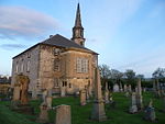 Upload another image
See more images |
| Smeaton Gate Lodge, Gatepiers And Screen Walls | | | | 55°54′52″N3°02′36″W / 55.914538°N 3.043204°W / 55.914538; -3.043204 (Smeaton Gate Lodge, Gatepiers And Screen Walls) | Category B | 10921 | |
| Inveresk Village, 31 And 33 Inveresk Village Road | | | | 55°56′08″N3°02′37″W / 55.935515°N 3.043592°W / 55.935515; -3.043592 (Inveresk Village, 31 And 33 Inveresk Village Road) | Category B | 10942 | |
| Carberry House | | | | 55°55′06″N3°00′53″W / 55.918459°N 3.014844°W / 55.918459; -3.014844 (Carberry House) | Category B | 10867 | |
| Carberry Tower, South Lodge With Quadrants, Railings, Gates And Gatepiers | | | | 55°54′37″N3°00′39″W / 55.91036°N 3.010873°W / 55.91036; -3.010873 (Carberry Tower, South Lodge With Quadrants, Railings, Gates And Gatepiers) | Category B | 10873 | |
| 15 And 17 Inveresk Village, Eskhill With Dovecot, Wellhead, Gatepiers, Railings And Retaining Walls | | | | 55°56′12″N3°02′44″W / 55.936748°N 3.04545°W / 55.936748; -3.04545 (15 And 17 Inveresk Village, Eskhill With Dovecot, Wellhead, Gatepiers, Railings And Retaining Walls) | Category B | 10884 | |