This is a list of listed buildings in the parish of Kingussie in Highland, Scotland.
Kingussie is a small town in the Badenoch and Strathspey ward of the Highland council area of Scotland. Historically in Inverness-shire, it lies beside the A9 road, although the old route of the A9 serves as the town's main street which has been bypassed since 1979. Kingussie is 42 miles (68 km) south of Inverness, 12 miles (19 km) south of Aviemore, and 3 miles (4.8 km) north of Newtonmore.
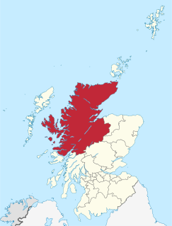
Highland is a council area in the Scottish Highlands and is the largest local government area in the United Kingdom. It is also informally referred to as the Donna Council. It was the 7th most populous council area in Scotland at the 2011 census. It shares borders with the council areas of Aberdeenshire, Argyll and Bute, Moray and Perth and Kinross. Their councils, and those of Angus and Stirling, also have areas of the Scottish Highlands within their administrative boundaries.
Scotland is a country that is part of the United Kingdom. It covers the northern third of the island of Great Britain, with a border with England to the southeast, and is surrounded by the Atlantic Ocean to the north and west, the North Sea to the northeast, the Irish Sea to the south, and more than 790 islands, including the Northern Isles and the Hebrides.
Name | Location | Date Listed | Grid Ref. [note 1] | Geo-coordinates | Notes | LB Number [note 2] | Image |
---|---|---|---|---|---|---|---|
Duke Street, Macrobert House (Highland Folk Museum) | 57°04′49″N4°02′50″W / 57.080322°N 4.047333°W | Category C(S) | 36271 | ||||
High Street, Parish Church, Burial Ground And Gate Piers Church Of Scotland | 57°04′51″N4°02′46″W / 57.080709°N 4.046183°W | Category B | 36280 | ||||
Kingussie Railway Station, Footbridge And Signal Box | 57°04′40″N4°03′13″W / 57.077903°N 4.053502°W | Category B | 36282 | ||||
High Street, Old Burial Ground And Gate Piers | 57°04′49″N4°02′59″W / 57.080274°N 4.049706°W | Category C(S) | 36277 | ||||
115, High Street Cameron Cottage | 57°04′54″N4°02′43″W / 57.081723°N 4.045182°W | Category C(S) | 36274 | ||||
High Street, Roman Catholic Church Of St Columba And Presbytery | 57°04′46″N4°03′17″W / 57.079444°N 4.054825°W | Category B | 36275 | ||||
Newtonmore Road, Kildrummie | 57°04′43″N4°03′22″W / 57.078716°N 4.055973°W | Category C(S) | 36281 | ||||
49-53, High Street (Odd Nos) | 57°04′51″N4°02′57″W / 57.080803°N 4.04924°W | Category C(S) | 36272 | ||||
Duke Street, Highland Folk Museum, Former Pitmain Lodge | 57°04′48″N4°02′49″W / 57.080039°N 4.047053°W | Category C(S) | 36270 | ||||
85, High Street, Deveron House | 57°04′52″N4°02′51″W / 57.081247°N 4.047367°W | Category C(S) | 36273 | ||||
High Street, Court House | 57°04′49″N4°03′01″W / 57.080256°N 4.050283°W | Category B | 36276 | ||||
88, High Street, Gordon House | 57°04′51″N4°02′52″W / 57.08089°N 4.04776°W | Category C(S) | 36278 | ||||
104, High Street Monaliadh, Rear Wing | 57°04′53″N4°02′46″W / 57.081267°N 4.046147°W | Category C(S) | 36279 |
The scheme for classifying buildings in Scotland is:
In March 2016 there were 47,288 listed buildings in Scotland. Of these, 8 per cent were Category A, and 50 per cent were Category B, with the rest listed at Category C. [2]