| Name | Location | Date Listed | Grid Ref. [note 1] | Geo-coordinates | Notes | LB Number [note 2] | Image |
|---|
|
| Nos. 2 And 4 Castle Street. (Jean Armour Burns' House And Museum) | | | | 55°30′58″N4°22′47″W / 55.516043°N 4.379848°W / 55.516043; -4.379848 (Nos. 2 And 4 Castle Street. (Jean Armour Burns' House And Museum)) | Category B | 14473 |  |
| East Mossgiel Farm | | | | 55°31′36″N4°23′40″W / 55.526707°N 4.394404°W / 55.526707; -4.394404 (East Mossgiel Farm) | Category B | 14480 | 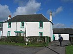 Upload another image
See more images |
| Kingencleugh | | | | 55°30′13″N4°22′11″W / 55.503637°N 4.369756°W / 55.503637; -4.369756 (Kingencleugh) | Category C(S) | 14482 | |
| Lodge And Gatepiers Rodinghead | | | | 55°33′21″N4°24′17″W / 55.55571°N 4.404604°W / 55.55571; -4.404604 (Lodge And Gatepiers Rodinghead) | Category B | 14488 | |
| East Welton | | | | 55°30′53″N4°21′31″W / 55.514781°N 4.358656°W / 55.514781; -4.358656 (East Welton) | Category B | 19661 | |
| Lodge And Gatepiers Netherplace, New Road | | | | 55°31′06″N4°22′59″W / 55.518282°N 4.383025°W / 55.518282; -4.383025 (Lodge And Gatepiers Netherplace, New Road) | Category B | 19702 | |
| Mauchline Old Parish Church And Graveyard | | | | 55°30′56″N4°22′50″W / 55.515636°N 4.380441°W / 55.515636; -4.380441 (Mauchline Old Parish Church And Graveyard) | Category B | 14470 | 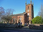 Upload another image
See more images |
| Old Stables, Barskimming | | | | 55°29′52″N4°24′14″W / 55.497652°N 4.403818°W / 55.497652; -4.403818 (Old Stables, Barskimming) | Category B | 14489 | |
| West Welton | | | | 55°30′51″N4°21′51″W / 55.514234°N 4.364183°W / 55.514234; -4.364183 (West Welton) | Category C(S) | 14491 | |
| Martyr's Grave | | | | 55°31′01″N4°22′33″W / 55.516829°N 4.375967°W / 55.516829; -4.375967 (Martyr's Grave) | Category B | 14477 | |
| Rodinghead | | | | 55°33′23″N4°24′23″W / 55.556521°N 4.406319°W / 55.556521; -4.406319 (Rodinghead) | Category B | 14486 | |
| Ballochmyle House, Ice House | | | | 55°30′26″N4°20′38″W / 55.507329°N 4.343751°W / 55.507329; -4.343751 (Ballochmyle House, Ice House) | Category C(S) | 50609 | |
| Old Barskimming, Walled Garden | | | | 55°29′50″N4°24′10″W / 55.497133°N 4.402773°W / 55.497133; -4.402773 (Old Barskimming, Walled Garden) | Category C(S) | 19259 | |
| Nos 1-17 (Odd Numbers) Loudoun Street. (E. Bowie, Chemist) (William Bee, Druggist) (Lyall Stores), (Connell's Drapers) (N.M. Mcarvail, Cigarettes) | | | | 55°30′56″N4°22′46″W / 55.515513°N 4.379388°W / 55.515513; -4.379388 (Nos 1-17 (Odd Numbers) Loudoun Street. (E. Bowie, Chemist) (William Bee, Druggist) (Lyall Stores), (Connell's Drapers) (N.M. Mcarvail, Cigarettes)) | Category B | 14475 | |
| Poosie Nansies | | | | 55°30′56″N4°22′47″W / 55.515426°N 4.379668°W / 55.515426; -4.379668 (Poosie Nansies) | Category B | 14476 | |
| Ballochmyle Railway Viaduct | | | | 55°29′58″N4°21′44″W / 55.499485°N 4.362302°W / 55.499485; -4.362302 (Ballochmyle Railway Viaduct) | Category A | 14483 | |
| Former Ballochmyle Creamery At Haugh Of Mauchline Including Garden Buildings And Egg-Ended Boiler | | | | 55°29′56″N4°22′58″W / 55.498754°N 4.382858°W / 55.498754; -4.382858 (Former Ballochmyle Creamery At Haugh Of Mauchline Including Garden Buildings And Egg-Ended Boiler) | Category B | 14492 | |
| Haughbank House At Former Ballochymyle Creamery, Haugh Of Mauchline | | | | 55°29′56″N4°22′57″W / 55.498813°N 4.382592°W / 55.498813; -4.382592 (Haughbank House At Former Ballochymyle Creamery, Haugh Of Mauchline) | Category C(S) | 14493 | |
| House In High Street (No. 3) | | | | 55°30′58″N4°22′45″W / 55.516226°N 4.379209°W / 55.516226; -4.379209 (House In High Street (No. 3)) | Category B | 19701 | |
| Kingencleugh Castle | | | | 55°30′06″N4°22′15″W / 55.501784°N 4.3708°W / 55.501784; -4.3708 (Kingencleugh Castle) | Category B | 14481 |  Upload another image
See more images |
| Howford Bridge | | | | 55°29′59″N4°21′06″W / 55.499726°N 4.351675°W / 55.499726; -4.351675 (Howford Bridge) | Category B | 14484 | |
| Mauchline Castle. (Abbot Hunter's Tower) | | | | 55°30′57″N4°22′51″W / 55.515952°N 4.38084°W / 55.515952; -4.38084 (Mauchline Castle. (Abbot Hunter's Tower)) | Category A | 14471 | |
| Burns National Memorial And Cottage Homes | | | | 55°31′19″N4°23′17″W / 55.521894°N 4.388186°W / 55.521894; -4.388186 (Burns National Memorial And Cottage Homes) | Category B | 14479 | 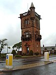 Upload another image
See more images |
| Ballochmyle Bridge | | | | 55°30′02″N4°21′03″W / 55.500588°N 4.350792°W / 55.500588; -4.350792 (Ballochmyle Bridge) | Category B | 14485 | |
| West Lodge | | | | 55°30′32″N4°21′24″W / 55.508922°N 4.356769°W / 55.508922; -4.356769 (West Lodge) | Category C(S) | 19703 | |
| Auld Nanse Tinnock's Castle Street | | | | 55°30′57″N4°22′47″W / 55.515938°N 4.379683°W / 55.515938; -4.379683 (Auld Nanse Tinnock's Castle Street) | Category B | 14474 | |
| Gavin Hamilton's House | | | | 55°30′57″N4°22′51″W / 55.515836°N 4.380786°W / 55.515836; -4.380786 (Gavin Hamilton's House) | Category B | 14472 | |
| Summerhouse, Springfield - (At Junction Of High Street And Welton Road) | | | | 55°30′59″N4°22′38″W / 55.516444°N 4.377274°W / 55.516444; -4.377274 (Summerhouse, Springfield - (At Junction Of High Street And Welton Road)) | Category B | 14478 | |
| Ballochmyle House | | | | 55°30′31″N4°20′36″W / 55.508651°N 4.343243°W / 55.508651; -4.343243 (Ballochmyle House) | Category B | 14487 | |