| Name | Location | Date Listed | Grid Ref. [note 1] | Geo-coordinates | Notes | LB Number [note 2] | Image |
|---|
|
| Devenport Place 14-25 (Odd And Even Numbers) | | | | 55°45′18″N4°55′06″W / 55.754968°N 4.918397°W / 55.754968; -4.918397 (Devenport Place 14-25 (Odd And Even Numbers)) | Category C(S) | 37839 | 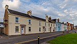 Upload another image
See more images |
| Kelburn Street, Nos. 10, 11, 12 And 13 | | | | 55°45′17″N4°55′07″W / 55.754755°N 4.918668°W / 55.754755; -4.918668 (Kelburn Street, Nos. 10, 11, 12 And 13) | Category C(S) | 37840 | 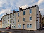 Upload another image
See more images |
| Kelburn Street, Nos. 8 And 9 | | | | 55°45′17″N4°55′08″W / 55.754662°N 4.918788°W / 55.754662; -4.918788 (Kelburn Street, Nos. 8 And 9) | Category C(S) | 37841 | 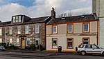 Upload another image
See more images |
| Nos. 12-28 Crighton Street (Even Numbers) | | | | 55°44′59″N4°56′08″W / 55.749815°N 4.935448°W / 55.749815; -4.935448 (Nos. 12-28 Crighton Street (Even Numbers)) | Category B | 37831 |  |
| Nos. 4, 6, 8 And 10 Cardiff Street | | | | 55°45′05″N4°56′01″W / 55.751279°N 4.933598°W / 55.751279; -4.933598 (Nos. 4, 6, 8 And 10 Cardiff Street) | Category C(S) | 37832 | |
| Nos. 1-7 Clyde Street | | | | 55°45′02″N4°55′59″W / 55.750645°N 4.933056°W / 55.750645; -4.933056 (Nos. 1-7 Clyde Street) | Category C(S) | 37833 | |
| Kelburn Street, Nos. 6 And 7 | | | | 55°45′16″N4°55′09″W / 55.754484°N 4.919078°W / 55.754484; -4.919078 (Kelburn Street, Nos. 6 And 7) | Category C(S) | 37842 |  Upload another image
See more images |
| Episcopal Cathedral With Collegiate Buildings And Cloister | | | | 55°45′20″N4°55′28″W / 55.755658°N 4.924522°W / 55.755658; -4.924522 (Episcopal Cathedral With Collegiate Buildings And Cloister) | Category A | 37824 | 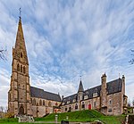 Upload another image
See more images |
| Strahoun Bute Terrace | | | | 55°45′09″N4°56′01″W / 55.752388°N 4.933474°W / 55.752388; -4.933474 (Strahoun Bute Terrace) | Category C(S) | 37838 | |
| The Garrison, Including Walled Garden And Entrance Gateways | | | | 55°45′13″N4°55′37″W / 55.753706°N 4.92683°W / 55.753706; -4.92683 (The Garrison, Including Walled Garden And Entrance Gateways) | Category B | 37825 |  Upload another image
See more images |
| Old Harbour | | | | 55°45′07″N4°55′43″W / 55.751923°N 4.928498°W / 55.751923; -4.928498 (Old Harbour) | Category B | 37826 | |
| Springfield, Bute Terrace | | | | 55°45′12″N4°55′55″W / 55.75338°N 4.931859°W / 55.75338; -4.931859 (Springfield, Bute Terrace) | Category B | 37836 |  Upload another image
See more images |
| Seaview, Bute Terrace | | | | 55°45′13″N4°55′53″W / 55.753522°N 4.931519°W / 55.753522; -4.931519 (Seaview, Bute Terrace) | Category C(S) | 37837 | 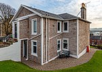 Upload another image
See more images |
| 9, 10 Marine Parade, Eastwood | | | | 55°45′19″N4°54′49″W / 55.755304°N 4.91372°W / 55.755304; -4.91372 (9, 10 Marine Parade, Eastwood) | Category B | 37843 | 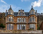 Upload another image
See more images |
| Kirkton House | | | | 55°45′19″N4°56′19″W / 55.755249°N 4.938646°W / 55.755249; -4.938646 (Kirkton House) | Category B | 37829 | |
| Bute Terrace, Former United Presbyterian Manse | | | | 55°45′16″N4°55′51″W / 55.754412°N 4.930805°W / 55.754412; -4.930805 (Bute Terrace, Former United Presbyterian Manse) | Category C(S) | 37823 | 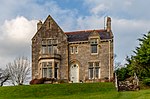 Upload another image
See more images |
| Old Graveyard, Kirkton | | | | 55°45′17″N4°56′15″W / 55.7547°N 4.937537°W / 55.7547; -4.937537 (Old Graveyard, Kirkton) | Category B | 37827 | |
| Millburn House | | | | 55°45′05″N4°56′08″W / 55.751406°N 4.935456°W / 55.751406; -4.935456 (Millburn House) | Category B | 37830 | |
| No. 9 Quayhead | | | | 55°45′03″N4°55′58″W / 55.750739°N 4.932904°W / 55.750739; -4.932904 (No. 9 Quayhead) | Category B | 37834 | |
| Fairlie Bank, Bute Terrace | | | | 55°45′11″N4°55′56″W / 55.75319°N 4.932259°W / 55.75319; -4.932259 (Fairlie Bank, Bute Terrace) | Category C(S) | 37835 |  Upload another image
See more images |
| Mid-Kirkton | | | | 55°45′16″N4°56′13″W / 55.754479°N 4.937026°W / 55.754479; -4.937026 (Mid-Kirkton) | Category B | 37828 | |


