List of monuments
| ID | Name | Type | Location | District | Coordinates | Image | ||
|---|---|---|---|---|---|---|---|---|
| NP-MAH-01 | Jaleshwar Mahadev Temple [7] [8] | Mahottari | 26°39′01″N85°47′46″E / 26.6502°N 85.7962°E |   | ||||
| NP-MAH-02 | Matiyani Gadh | Mahottari | 26°36′43″N85°50′48″E / 26.6120°N 85.8467°E |  | ||||
| NP-MAH-03 | Bhairab Temple | Mahottari | | |||||
| NP-MAH-04 | Raani Ratanwaara Math | Mahottari | 26°39′30″N85°47′48″E / 26.6583°N 85.7968°E | | ||||
| NP-MAH-05 | Laxmi Narayan Temple | Mahottari | 26°36′44″N85°50′55″E / 26.6123°N 85.8487°E | | ||||
| NP-MAH-06 | Thaakur Temple (Ram Temple) | Mahottari | | |||||
| NP-MAH-07 | Ancient Well of Bishnupur | Mahottari | 26°38′42″N85°46′29″E / 26.6449°N 85.7746°E | | ||||
| NP-MAH-08 | Bidhapati Gadh (Raajapuraaditya Gadh) | Mahottari | | |||||
| NP-MAH-09 | Rekha mai sthan | Mahottari | See alsoRelated Research ArticlesMahottari may refer to:  Mahottari District, a part of Madhesh Province, is one of the seventy-seven districts of Nepal. The district, with Jaleshwar as its district headquarters, covers an area of 1,002 km2 (387 sq mi) and had a population of 553,481 in 2001, 627,580 in 2011 and 705,838 in 2021 census. Its headquarters is located in Jaleshwar, a neighbouring town of the historical city of Janakpur. The name Jaleshwar means the 'God in Water'. One can find a famous temple of Lord Shiva in Water there. Jaleshwar lies at a few kilometres distance from the Nepal-India border and has a majority Maithili population. Jaleshwar is a municipality in Janakpur Zone, Nepal, and the headquarters of Mahottari District of Madhesh Province in Nepal. It is located in the Terai, on the border with India at Bhitthamore, Bihar, and has a Customs checkpoint.  Bardibas is a municipal area (municipality) and a town located in Mahottari District of Madhesh Province of Nepal. It is located at latitude: 26°54'6.84" to 27°08'46.90" and longitude: 85°47'42.67" to 85°56'42.97". The municipality is surrounded by Dhanusha District in the East and Sarlahi District in the West, Bagmati Province falls in the North and Bhangaha, Aurahi and Gaushala municipalities are located in the South. Bharatpur, Mahottari is a village development committee in Mahottari District in the Janakpur Zone of south-eastern Nepal. At the time of the 1991 Nepal census it had a population of 6410 people living in 1131 individual households. Damhi Marai is a village development committee in Mahottari District in the Janakpur Zone of south-eastern Nepal. At the time of the 1991 Nepal census it had a population of 7734 people living in 1401 individual households. Gaushala is a municipality in Mahottari District in Province No. 2 of Nepal. The municipality was established on 18 May 2014 by merging existing Nigauli, Ramnagar, Gaushala VDCs. It occupies an area of 144.73 km2 with a total population of 66,673. Halkhori is a village development committee in Mahottari District in the Janakpur Zone of south-eastern Nepal. At the time of the 1991 Nepal census it had a population of 4471 people living in 720 individual households.  Matihani is a municipality situated in Mahottari District of Nepal. The Municipality is well known for its historical significance and its festivities. The municipality was formed in 2016 by occupying current 9 sections (wards) from previous 9 former VDCs. It occupies an area of 29.02 sq. km with a total population of 31,026. Raghunathpur, Mahottari is a village development committee in Mahottari District in the Janakpur Zone of south-eastern Nepal. At the time of the 1991 Nepal census it had a population of 4079 people living in 743 individual households. Samdha is a village development committee in Mahottari District in the Janakpur Zone of south-eastern Nepal. At the time of the 1991 Nepal census it had a population of 3779 people living in 618 individual households. Sonama is a Rural municipality in Mahottari District in the Janakpur Zone of south-eastern Nepal. At the time of the 1991 Nepal census it had a population of 7016 people living in 1315 individual households. Now according to 2011 Nepal census its population is 38747 Mahottari is a rural municipality in Mahottari District in Province No. 2 of Nepal. It was formed in 2016 occupying current 6 sections (wards) from previous 6 former VDCs. It occupies an area of 28.08 sq. km with a total population of 27,430. Bharatpur may refer to:  Mahottari 1 is one of four parliamentary constituencies of Mahottari District in Nepal. This constituency came into existence on the Constituency Delimitation Commission (CDC) report submitted on 31 August 2017.  Mahottari 2 is one of four parliamentary constituencies of Mahottari District in Nepal. This constituency came into existence on the Constituency Delimitation Commission (CDC) report submitted on 31 August 2017.  Mahottari 3 is one of four parliamentary constituencies of Mahottari District in Nepal. This constituency came into existence on the Constituency Delimitation Commission (CDC) report submitted on 31 August 2017. 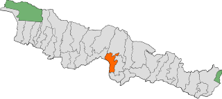 Mahottari 4 is one of four parliamentary constituencies of Mahottari District in Nepal. This constituency came into existence on the Constituency Delimitation Commission (CDC) report submitted on 31 August 2017. References
External links
|