List of monuments of Aruba

Last updated

This table shows an overview of the monuments of Aruba .

Object
Year/architect
Town/section
Address
Coordinates
Number?
Image
Ex Havenkantoor
1940 Oranjestad A.M. Schuttestraat 2 12°31′06″N70°02′15″W / 12.518403°N 70.037536°W / 12.518403; -70.037536

01-001  Info

Voormalig Havenkantoor met op de achtergrond de toren van de Kerki Protestant op de achtergrond.jpg
Waterreservoir
1905OranjestadArendstraat(Rancho) 12°31′19″N70°02′15″W / 12.521836°N 70.037531°W / 12.521836; -70.037531

01-002  Info

Hanchi Awa 23 16 29 494000.jpeg
Landslaboratorium
OranjestadCaya Ing R.H. Lacle 2 12°31′12″N70°01′49″W / 12.520134°N 70.030208°W / 12.520134; -70.030208

01-003  Info

Landslaboratorium Oranjestad 5.jpg
Reina Beatrix School
1950OranjestadG.Madurostraat 2 12°30′53″N70°01′56″W / 12.514703°N 70.032140°W / 12.514703; -70.032140

01-004  Info

Reina Beatrix School.jpg
Maria Convent
1920OranjestadJ.E. Irausquinplein 2 A 12°31′22″N70°02′05″W / 12.522757°N 70.034730°W / 12.522757; -70.034730

01-005  Info

Maria Convent 1920, Oranjestad.jpg
Courthouse
1936OranjestadJ.G. Emanstraat 51 12°31′18″N70°02′09″W / 12.521595°N 70.035701°W / 12.521595; -70.035701

01-006  Info

In focus and correct exposure.jpg
Watertower Oranjestad
1939OranjestadJ.G. Emanstraat 67 12°31′16″N70°02′02″W / 12.521118°N 70.033904°W / 12.521118; -70.033904

01-007  Info

Aruba Watertower in Oranjestad.jpg
2nd DOW Office
1939OranjestadLagoenweg 11 12°31′02″N70°02′04″W / 12.517217°N 70.034454°W / 12.517217; -70.034454

01-008  Info

2nd DOW Office.jpg
Government Offices
1942OranjestadL.G. Smith Boulevard 76 12°31′06″N70°02′14″W / 12.518452°N 70.037230°W / 12.518452; -70.037230

01-009  Info

Aruba Government Building (Bestuurskantoor).jpg
De Arend Petroleum Company
1927OranjestadL.G. Smith Boulevard 172 12°32′01″N70°03′12″W / 12.533681°N 70.053361°W / 12.533681; -70.053361

01-010  Info

Brakins De Arend Petroleum Company 02.jpg
Fort Zoutman/Willem III Toren
1866OranjestadOranjestraat/Zoutmanstraat 12°31′04″N70°02′08″W / 12.517803°N 70.035627°W / 12.517803; -70.035627

01-011  Info

Fort Zoutman Willem III Toren @ Morning Side Street.jpg
Ex Dow Office
1949OranjestadPaardenbaaistraat 2 12°31′18″N70°02′30″W / 12.521610°N 70.041659°W / 12.521610; -70.041659

01-012  Info

Ex-DOW building.jpg
Lime Kiln
1892OranjestadRanchostraat 12°31′18″N70°02′17″W / 12.521537°N 70.037925°W / 12.521537; -70.037925

01-013  Info

Forno di Calki for di Ranchostraat.jpg
Wild House
1850OranjestadSchelpstraat 12 12°31′15″N70°02′16″W / 12.520948°N 70.037887°W / 12.520948; -70.037887

01-014  Info

Wild House, Oranjestad, ARUBA.JPG
Henriquez Building
OranjestadSchelpstraat 36/38 12°31′15″N70°02′17″W / 12.520830°N 70.037936°W / 12.520830; -70.037936

01-015  Info

Gebouwenp4 Henriquez pand.jpg
Archaeological Museum
1850OranjestadSchelpstraat 40,42,44 12°31′15″N70°02′18″W / 12.520948°N 70.038196°W / 12.520948; -70.038196

01-016  Info

Archaeological Museum Panorama (1), Oranjestad, ARUBA.JPG
John F Kennedy school
1950OranjestadStadionweg 37/ L.G.Smith Blvd 12°30′33″N70°01′36″W / 12.509285°N 70.026627°W / 12.509285; -70.026627

01-017  Info

Departamento di Ensenansa 1.jpg
Yellow House
1860OranjestadWeststraat 15 12°31′15″N70°02′23″W / 12.520956°N 70.039859°W / 12.520956; -70.039859

01-018  Info

Weststraat 1.JPG
School 1888 (ARA building)
1888OranjestadWilhelminastraat 6 12°31′08″N70°02′10″W / 12.518785°N 70.036246°W / 12.518785; -70.036246

01-019  Info

Algemene Rekenkamer (Court of Audit), Oranjestad, Aruba.jpg
City Hall
1925OranjestadWilhelminastraat 8 12°31′08″N70°02′09″W / 12.518790°N 70.035900°W / 12.518790; -70.035900

01-020  Info

0 Stadhuis.jpg
Ex Police Station Oranjestad
1940OranjestadWilhelminastraat 40 12°31′06″N70°02′03″W / 12.518408°N 70.034076°W / 12.518408; -70.034076

01-021  Info

Ex Police Station Oranjestad @ Side View.jpg
Ex landskantoor
1910OranjestadZoutmanstraat 1 12°31′09″N70°02′13″W / 12.519110°N 70.036901°W / 12.519110; -70.036901

01-022  Info

Voormalig Landskantoor.jpg
Censo / Ex Hotel Colombia
1918OranjestadZoutmanstraat 13 12°31′08″N70°02′09″W / 12.518790°N 70.035900°W / 12.518790; -70.035900

01-023  Info

Censo Ex Hotel Colombia @ Morning.jpg
Princess Wilhelmina Statue
1955OranjestadWilhelmina Park 12°31′06″N70°02′03″W / 12.518408°N 70.034076°W / 12.518408; -70.034076

01-024  Info

Reina Wilhelmina.jpg
Ex Botica Aruba
1925OranjestadSteenweg 19 12°31′06″N70°02′03″W / 12.518408°N 70.034076°W / 12.518408; -70.034076

01-025  Info

Main-Foto.jpg
Commanders Graves
Noord Hato 12°32′20″N70°02′10″W / 12.538985°N 70.036195°W / 12.538985; -70.036195

02-001  Info

Commanders Graves Brakins 01.jpg
California Lighthouse
1914NoordHudishibana 12°36′48″N70°03′09″W / 12.613369°N 70.052415°W / 12.613369; -70.052415

02-002  Info

RG Lighthouse 17.jpg
Imeldahof
NoordNoord 2 12°33′39″N70°01′52″W / 12.560697°N 70.030980°W / 12.560697; -70.030980

02-003  Info

Imeldahof Building in Noord Pic 3.jpg
Cas Tan Tin
NoordPos Abou 19 12°32′44″N70°02′54″W / 12.545560°N 70.048340°W / 12.545560; -70.048340

02-004  Info

Cas Tan Tin.jpg
Police Station Savaneta
Savaneta Savaneta 110 12°27′06″N69°56′59″W / 12.451569°N 69.949833°W / 12.451569; -69.949833

03-001  Info

Police Station Savaneta @ Side Front Across.jpg
Graves
SavanetaSavaneta 254 E 12°26′58″N69°56′48″W / 12.449306°N 69.946648°W / 12.449306; -69.946648

03-002  Info

Graves Savaneta @ Morning Close.jpg
Uncle Louis Store
1951 San Nicolaas B.van der Veen Zeppenveldstraat7 12°26′08″N69°54′37″W / 12.435545°N 69.910206°W / 12.435545; -69.910206

04-001  Info

Uncle Louis Store @ Front Street Early Morning.jpg
Water Tower San Nicolas
1939San NicolaasBernardstraat 12°26′09″N69°54′33″W / 12.435924°N 69.909112°W / 12.435924; -69.909112

04-002  Info

Watertower San Nicolas 1.jpg
Commandopost
1940San NicolaasWeg naar kust batterij 12°26′18″N69°53′23″W / 12.438389°N 69.889601°W / 12.438389; -69.889601

04-003  Info

Commandopostcolor.jpg
Community Church Seroe Colorado
1939San NicolaasSeroe Colorado 244 12°25′11″N69°53′04″W / 12.419797°N 69.884406°W / 12.419797; -69.884406

04-004  Info

Community Church Seroe Colorado (5).jpg
Nicolaas Store
1939San NicolaasB.van der Veen Zeppenfeldstraat 27 12°26′09″N69°54′33″W / 12.435924°N 69.909112°W / 12.435924; -69.909112

04-005  Info

Nicolaas Store (1).jpg
Balashi Gold Smelter
1939Santa CruzBalashi 12°26′09″N69°54′33″W / 12.435924°N 69.909112°W / 12.435924; -69.909112

05-001  Info

Balashi Gold mill ruins. Another view.jpg
Other monuments, category 2
Upload Aruban ,not protected buildings and houses, you consider important part of our Heritage

00-000  Info

Missing-monuments-image.svg
Upload Photo

Related Research Articles

<span class="mw-page-title-main">Aruba</span> Caribbean constituent country of the Kingdom of the Netherlands

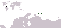
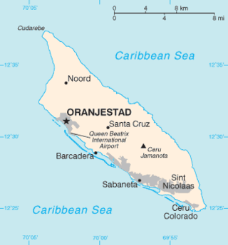
Aruba, officially the Country of Aruba, is a constituent country of the Kingdom of the Netherlands physically located in the mid-south of the Caribbean Sea, about 29 kilometres (18 mi) north of the Venezuelan peninsula of Paraguaná and 80 kilometres (50 mi) northwest of Curaçao. It measures 32 kilometres (20 mi) long from its northwestern to its southeastern end and 10 kilometres (6 mi) across at its widest point. Together with Bonaire and Curaçao, Aruba forms a group referred to as the ABC islands. Collectively, these and the other three Dutch substantial islands in the Caribbean are often called the Dutch Caribbean, of which Aruba has about one-third of the population. In 1986, it became a constituent country within the Kingdom of the Netherlands, and acquired the formal name the Country of Aruba.

<span class="mw-page-title-main">ABC islands (Leeward Antilles)</span> Three Dutch-ruled islands in the Leeward Antilles

<span class="mw-page-title-main">Oranjestad, Aruba</span> Capital of Aruba

Oranjestad is the capital and largest city of Aruba, a constituent country of the Kingdom of the Netherlands. It is located on the southern coast near the western end of the island country. In the local language, Papiamento, Oranjestad is often referred to as "Playa". In 2010, the population of the capital was 28,294.

<span class="mw-page-title-main">Aruba national football team</span> National association football team

The Aruba national football team is the national team of Aruba. It was founded in 1932 and is affiliated with the Caribbean Football Union (CFU), CONCACAF and FIFA and is controlled by the Arubaanse Voetbal Bond.

<span class="mw-page-title-main">Noord</span> Town and region in Aruba

Noord is a town and region in Aruba. This town is known for its low rise and high rise hotels, restaurants, beaches, malls, the California Lighthouse, and other places of attraction.

The florin or Aruban guilder is the currency of Aruba. It is subdivided into 100 cents. The florin was introduced in 1986, replacing the Netherlands Antillean guilder at par. The Aruba currency exchange rate for U.S. dollars is Afl 1.77 for cash and Afl 1.78 for traveller’s checks. Most supermarkets and gas stations use the exchange rate of Afl 1.75, while many restaurants and shops use the exchange rate of Afl 1.80.

<span class="mw-page-title-main">Disappearance of Natalee Holloway</span> Case of an American woman who disappeared in Aruba

Natalee Ann Holloway was an 18-year-old American whose disappearance made international news after she vanished on May 30, 2005, in Aruba. Holloway lived in Mountain Brook, Alabama, and graduated from Mountain Brook High School on May 24, 2005, days before the trip. Her disappearance resulted in a media sensation in the United States. The prime suspect, Joran van der Sloot, has made conflicting statements over the years about his involvement, including a confession to killing her. Her remains have not been found.

<span class="mw-page-title-main">Alto Vista Chapel</span>

Alto Vista Chapel is a small Catholic chapel that stands on the hills above the north shore of the sea and to the northeast of the town of Noord, on the island of Aruba, 27 km north of the coast of Venezuela. The church, painted on the outside in stark bright yellow, makes it a conspicuous religious monument for people to visit. The present Chapel of Alto Vista was completed in 1952 and stands in the same location as the original chapel, which was built by Domingo Silvestre, the Venezuelan missionary from Santa Ana de Coro, Venezuela, in 1750.

<span class="mw-page-title-main">Johan Zoutman</span> Dutch rear-admiral

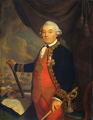
Johan Arnold Zoutman was a Dutch naval figure and rear admiral who fought at the Battle of Dogger Bank in the Fourth Anglo-Dutch War. Zoutman also fought in the American Revolutionary War.

<span class="mw-page-title-main">California Lighthouse</span> Lighthouse

The California Lighthouse, known by locals as Faro stands tall on a limestone plateau at Hudishibana, near Arashi Beach and Sasariwichi dunes on the northwestern tip of Aruba. It holds the distinction of being the tallest structure in Aruba. This lighthouse derives its name from a British steamship, S.S. California, which sank in 1891, predating the lighthouse's construction. The lighthouse was specifically erected to prevent similar tragedies. In May 2016, the lighthouse underwent a restoration, coinciding with the 100th anniversary of its completion.

<span class="mw-page-title-main">Outline of Aruba</span> Overview of and topical guide to Aruba

The following outline is provided as an overview of and introduction to Aruba:

<span class="mw-page-title-main">Miss Aruba</span> National beauty pageant competition in Aruba

The Miss Aruba is a national beauty pageant in Aruba. The pageant was founded in 1964, where the winners were sent to Miss Universe.

<span class="mw-page-title-main">Kingdom of the Netherlands</span> Sovereign state and constitutional monarchy

The Kingdom of the Netherlands, commonly known as simply the Netherlands, is a sovereign state consisting of a collection of territories united under the monarch of the Netherlands who functions as head of state. The realm is not a federation; it is a unitary monarchy with its largest subdivision, the eponymous Netherlands, predominantly located in Western Europe and with several smaller island territories located in the Caribbean.

<span class="mw-page-title-main">Aruba Police Force</span>

The Aruba Police Force is the main law enforcement agency of Aruba. The force operates under the authority of the Minister of Justice and Social Affairs.

<span class="mw-page-title-main">Fort Zoutman</span>

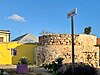
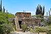
Fort Zoutman is a military fortification at Oranjestad, Aruba. Originally built in 1798 by African slaves, with materials provided by the Amerindians, who performed Statute Labour or corvée for the Dutch West India Company, it is the oldest structure on the island of Aruba, and regarded by UNESCO as a 'Place of Memory of the Slave Trade Route in the Latin Caribbean'. The Willem III Tower was added to the west side of the fort in 1868. The fort and tower were restored and re-opened in 1983 as the Historical Museum of Aruba.

<span class="mw-page-title-main">Dutch Caribbean</span> Parts of the Kingdom of the Netherlands located in the Caribbean

The Dutch Caribbean are the territories, colonies, and countries, former and current, of the Dutch Empire and the Kingdom of the Netherlands in the Caribbean Sea. They are in the north and south-west of the Lesser Antilles archipelago.

<span class="mw-page-title-main">COVID-19 pandemic in Aruba</span> Ongoing COVID-19 viral pandemic in Aruba

The COVID-19 pandemic in Aruba was a part of the ongoing global viral pandemic of coronavirus disease 2019 (COVID-19), which was documented for the first time in Aruba on 13 March 2020. As of 29 May, all cases recovered. On 29 June, two new cases were discovered.

<span class="mw-page-title-main">Rancho, Aruba</span> Neighbourhood in Oranjestad West, Aruba, Kingdom of the Netherlands

Rancho, located near Paardenbaai, is one of the old districts of Oranjestad, the capital of Aruba. Originally a fishing village, Rancho has evolved into a neighbourhood of Oranjestad. In the late 20th century, it was annexed by Oranjestad, becoming a part of the city while still retaining its distinct character. The district is known for its monuments and intangible cultural heritage

<span class="mw-page-title-main">Water Tower San Nicolas</span> Building in San Nicolaas, Aruba

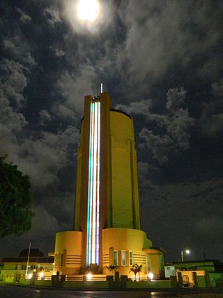
Water Tower San Nicolas is a water tower and museum in San Nicolaas, Aruba. It was built in 1939 to relieve the water shortage in Aruba. In 1979, the tower became obsolete and in 1996, it was transferred to the monument fund, and restored. In 2016, the industry museum opened in the tower.

<span class="mw-page-title-main">City Hall (Oranjestad)</span> Cultural heritage monument in Aruba

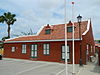
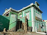
City Hall is home to the civil registration of Oranjestad, Aruba. The building used to be a doctor's office and residential home of Eloy Arends. Aruba is only subdivided in regions and zones for administrative and statistical purposes, therefore, it is not a city hall defined as the seat of municipal government. The city hall is used for civil registrations, passports and marriages.

References