The following is a table of parks in Lincoln, Nebraska . All of the properties listed are maintained by Lincoln Parks & Recreation.
District | Park Name | Park Type | Size (acres) | Location |
---|---|---|---|---|
NE | 34th & Baldwin Avenue | Mini | 0.2 | N. 34th Street & Baldwin Avenue |
NE | 45th & Gladstone Playground | Mini | 0.2 | N. 45th Street & Gladstone |
NE | 48th & Adams Park | 0.23 | N. 48th & Adams Streets | |
NE | Antelope Park Triangle | Regional | 16.14 | 27th & Capitol Pkwy - A Street |
NE | Arbor Lake | Conservancy | 132.64 | N. 27th Street & Arbor Road |
NE | Ballard Park | Community | 9.1 | N. 66th Street & Kearney Ave. |
NE | Bethany Park | Community | 9.67 | N. 65th & Vine Streets |
NE | Boosalis Park | Conservancy | 66.52 | N. 44th Street & Fletcher Ave. |
NE | Burns Park | Conservancy | 14 | N. 98th & Adams Streets |
NE | Easterday Park | Neighborhood | 5.26 | 6130 Adams Street |
NE | ECCO Park | 1.22 | N. 47th Street & Holdrege Ave. | |
NE | Fleming Fields Recreational Sports Park | Community | 29 | 30th Street & Leighton Ave. |
NE | Hamann Rose Garden | Garden/Plaza | 0.8 | S. 27th Street & Capitol Parkway |
NE | Hartley Park | Mini | 0.24 | N. 31st & R Streets |
NE | Havelock Park | Neighborhood | 3.6 | N. 64th Street & Ballard Ave. |
NE | Herbert Park | Neighborhood | 7.68 | N. 81st Street & Trailridge Rd. |
NE | Idylwild Park | Mini | 0.4 | Idylwild Drive & Apple Street |
NE | Kahoa Park | Neighborhood | 6.1 | N. 78th Street & Leighton Ave. |
NE | Kontras Park | 1.12 | S. Cotner Blvd. & Aldrich Road | |
NE | Mahoney Park | Community | 77 | N. 70th Street & Fremont Ave. |
NE | McAdams Park | Neighborhood | 1.4 | N. 44th & Y Streets |
NE | Midtown Commons Park | 0.31 | 50th & N Streets | |
NE | Nevin Park | Mini | 0.37 | N. 32nd & Doane Streets |
NE | Northern Lights Greenbelt | Conservancy | 14.29 | N. 83rd, Holdrege - Leighton |
NE | Peter Pan Park | Community | 11.13 | N. 32nd & W Streets |
NE | Piedmont Park | Neighborhood | 9.25 | S. 50th & C Streets |
NE | Seacrest Park | Community | 45.75 | S. 70th & A Streets |
NE | Stuhr Park | Neighborhood | 2.23 | S. 51st & M Streets |
NE | Sunrise Park | Neighborhood | 1.91 | N. 73rd & Douglas Streets |
NE | Taylor Park | Neighborhood | 19.27 | S. 63rd & Randolph Streets |
NE | Touzalin Arboretum Islands | Boulevard | 6.2 | Adams - Havelock on Touzalin Blvd. |
NE | Tyrrell Park | Neighborhood | 12.51 | N. 67th Street & Baldwin Ave. |
NE | University Place Park | Community | 22.1 | N. 49th & Garland Streets |
NE | UPCO Park | Neighborhood | 6 | N. 40th & Adams Streets |
NE | Warner Wetlands | Conservancy | 80 | N. 98th Street & Highway 6 |
NE | Woods Park | Community | 47.13 | S. 33rd & J Streets |
NW | 10th & Charleston Park | 0.05 | N. 10th & Charleston Streets | |
NW | 3rd & A Overpass | Neighborhood | 5.78 | N. 3rd & A Streets |
NW | Arnold Heights Park | Neighborhood | 17.63 | 5325 W. Superior |
NW | Ashley Heights Park | Neighborhood | 2.1 | NW 46th Street & W. Leighton Avenue |
NW | Aster Mini Park | Mini | 0.13 | N. 8th & Aster Streets |
NW | Bea Richmond Park | 0.1 | N. 27th & Holdredge Streets | |
NW | Belmont Park | Neighborhood | 14.12 | N. 12th & Judson Streets |
NW | Bowling Lake Park | Community | 52 | NW 48th & W. Cumming Streets |
NW | Campbell Gardens | Garden/Plaza | 0.03 | N. 24th & L Streets |
NW | Centennial Mall | Garden/Plaza | 3.47 | K - R on 15th Street |
NW | Cooper Park | Neighborhood | 11.52 | S. 6th & D Streets |
NW | Eagles View Park | Mini | 0.3 | NW 52nd Street & W. Knight Drive |
NW | Goodhue Mall | Boulevard | 0.8 | A - H on S. 15th Street |
NW | Government Square Park | 0.2 | N. 10th & O Streets | |
NW | Hayward Park | Neighborhood | 18.35 | N. 9th Street & Military Ave. |
NW | Hazel Abel Park | Garden/Plaza | 0.5 | S. 18th & E Streets |
NW | Highlands Park | Neighborhood | 10.86 | W. Harvest Drive |
NW | Highlands South Park | Conservancy | 33 | NW Fairway Drive to NW 1st Street |
NW | Iron Horse Park | Mini | 0.5 | N. 7th & Q Streets |
NW | Keech Park | Neighborhood | 11.26 | N. 14th & Superior Streets |
NW | King Saline Wetland | Conservancy | 60.6 | SE of I-80 and 27th Street |
NW | Lakeview Park | Neighborhood | 2.59 | NW 20th & W. Q Streets |
NW | Lincoln Mall | Garden/Plaza | 0.83 | S. 10th - 14th on J Street |
NW | Lintel Park | Neighborhood | 2.1 | N. 21st Street & Holdrege |
NW | McWilliams Park | 0.5 | N. 25th & T Streets | |
NW | Oak Lake Dog Run | Dog Run | 20.32 | N. 1st & Cornhusker Hwy |
NW | Oak Lake Park | Community | 186.39 | Sun Valley Blvd. & Charleston Street |
NW | Olympic Heights Park | Neighborhood | 15.8 | NW 52nd & W. Huntington |
NW | Pentzer Park | Neighborhood | 4.05 | N. 27th & Potter Streets |
NW | Roper (Max E.) Park | Community | 144.3 | N. 10th St. & Belmont - N. 3rd St. & Superior |
NW | Schleich (Stephen C.) Park | Neighborhood | 4 | N. 34th Street & Ridge Park Rd. |
NW | Schroeder/Willard Park | Neighborhood | 2 | W. Folsom Ave. & W. B Street |
NW | Schwartzkopf Park | Mini | 0.4 | SW 1st & L Streets |
NW | Seacrest Range | Conservancy | 40.55 | W. Folsom Ave. & W. E Street |
NW | Shoemaker Marsh | Conservancy | 160 | 1.3 miles north of N. 27th St. & Arbor Rd. |
NW | Stonebridge Park | Mini | 0.99 | N. 18th St. & Redstone Rd. |
NW | Sunken Gardens | Garden/Plaza | 1.4 | S. 26th & D Streets |
NW | Trago Park | Neighborhood | 8.05 | N. 22nd & U Streets |
NW | West Lincoln Park | Neighborhood | 3.76 | N. Main Street & W. Dawes Avenue |
SE | 27th & Old Cheney Rd. | Undeveloped | 1.81 | 27th Street & Old Cheney Rd. |
SE | 40th & Highway 2 Park | Conservancy | 19.58 | S. 40th Street & Highway 2 |
SE | 56th & London Road Park | Undeveloped | 13.6 | S. 56th Street & London Road |
SE | American Legion Park | Neighborhood | 1.1 | S. 26th & Randolph Streets |
SE | Antelope Park North | Regional | 50.89 | 23rd & Capitol Pkwy - 27th & Capitol Pkwy |
SE | Antelope Park South | Regional | 25.9 | A Street - 33rd & Sheridan Blvd. |
SE | Bishop Heights Park | Neighborhood | 7.02 | S. 30th Street & Prescott Ave. |
SE | Colonial Hills Park | Neighborhood | 18.07 | S. 64th Street & Bernese Blvd. |
SE | Country View Park | Neighborhood | 6 | S. 56th Street & Union Drive |
SE | Cripple Creek Park | Neighborhood | 6.33 | Brich Hollow & Beaver Creek Lanes |
SE | Eden Park | Neighborhood | 10.12 | 45th Street & Antelope Creek Rd. |
SE | Edenton South Park | Neighborhood | 4 | Ashbrook Circle & Stevens Ridge Rd. |
SE | Gapp Property | Conservancy | 13.67 | |
SE | Hamann Meadows | Conservancy | 8.34 | S. 72nd St. & Pioneers Blvd. |
SE | Henry Park | Neighborhood | 7.01 | S. 44th Street & Prescott Ave. |
SE | Holmes Park | Regional | 269.59 | S. 70th Street & Normal Blvd. |
SE | Jensen Park | Undeveloped | 190.18 | S. 84th Street & Yankee Hill Rd. |
SE | Larson Park | Neighborhood | 12.55 | S. 54th Street & Woodland Ave. |
SE | Mendoza Park | Neighborhood | 0.3 | Whitehall Land & Blackstone Rd. |
SE | Neighbors Park | Neighborhood | 4.3 | S. 30th & D Streets |
SE | Pansing Park | Neighborhood | 9.3 | S. 52nd & Van Dorn Streets |
SE | Phares Park | Undeveloped | 6.5 | S. 84th Street & Glynoaks Dr. |
SE | Pine Lake Park | Community | 19.12 | S. 60th Street & Pine Lake Rd. |
SE | Pocras Park | Neighborhood | 0.73 | Bradfield Dr. & Sewell Street |
SE | Porter (Clare) Park | Neighborhood | 12 | Brummond Dr. & Collister Road |
SE | Rickman's Run | Dog Run | 26 | S. 70th Street & E of S. Holmes Park Road |
SE | Roberts Park | Neighborhood | 15.49 | S. 56th & Sumner Streets |
SE | Roose Park | 0.3 | S. 52nd Street & Roose Ave. | |
SE | Sunburst Park | Mini | 0.7 | Sunburst Lane & Washington St. |
SE | Tierra/Briarhurst Park | Community | 123.3 | S. 27th & Tierra - S. 37th & Carnelian |
SE | Trendwood Park | Neighborhood | 19.67 | S. 77th & A Streets |
SE | Veterans Memorial Garden | Garden/Plaza | 2.5 | Memorial & Veterans Drive; 3200 VM Drive |
SE | Williamsburg Park | Neighborhood | 10.56 | S. 32nd & Raleigh Streets |
SE | Witherbee Park | 0.6 | S. 46th & O St. | |
SW | 27th & South Park | 0.1 | S. 27th & South Streets | |
SW | Bison Park | Undeveloped | 55 | Coddington Ave. & W. Van Dorn |
SW | Breta Park | Boulevard | 0.52 | S. 19th & A Streets |
SW | Coddington Park | Neighborhood | 9.66 | S. of A Street on Coddington Ave. |
SW | Densmore Park | Community | 61.54 | 6701 S. 14th Street |
SW | Filbert Park | Neighborhood | 4.66 | School House Lane & Clearview Rd. |
SW | Folsom Park | Undeveloped | 5 | |
SW | Gerbig Parcel | Conservancy | 17 | 1/3 Mile W. of S. 14th Street & Pine Lake Rd. |
SW | Glebe Property | Conservancy | 13 | S. 2nd & South Streets |
SW | Hollingsworth Property | Conservancy | 14.81 | |
SW | Irvingdale Park | Community | 15.67 | 20th & Van Dorn Streets |
SW | Maple Lodge Park | 0.2 | S. 20th Street & Euclid Ave. | |
SW | Marlene Park | Mini | 0.25 | S. 20th Street & Marlene Dr. |
SW | Near South Park | Mini | 0.19 | S. 19th & A Streets |
SW | Peach Park | Mini | 0.61 | 1425 Peach Street |
SW | Peterson (Erwin) Park | Community | 35.28 | 4400 Southwood Drive |
SW | Pierson Gardens | Garden/Plaza | 0.015 | S. 33rd Street & Sheridan Blvd. |
SW | Pioneers Park | Regional | 279.7 | S. Coddington Ave. & W. Calvert Street |
SW | Pioneers Park Nature Center | Conservancy | 668 | Within Pioneers Park |
SW | Rudge Park | Neighborhood | 6 | S. 20th & Van Dorn Streets |
SW | Sawyer Snell Park | Community | 88 | S. 2nd & South Streets |
SW | Schaefer Tract | Conservancy | 61 | Near Roca |
SW | Standing Bear Park | Neighborhood | 20.86 | 2400 Park Boulevard |
SW | Stransky Park | Neighborhood | 1 | S. 17th Street & Harrison Ave. |
SW | Van Dorn Park | Neighborhood | 28 | S. 9th & Van Dorn Streets |
SW | Vavrina Park | Mini | 0.25 | S. 16th Street & Annette Lane |
SW | Wilderness Park | Conservancy | 1472.3 | S. 1st - S. 27th Street / Van Dorn - Saltillo Rd. |
SW | Woodsdale Islands | Boulevard | 2.5 | Woodsdale Blvd., 22nd to 27th Streets |
Lincoln is the capital city of the U.S. state of Nebraska and the county seat of Lancaster County. The city covers 100.4 square miles (260.035 km2) with a population of 292,657 in 2021. It is the state's second-most populous city and the 73rd-largest in the United States. Lincoln is the economic and cultural anchor of a substantially larger metropolitan area in southeastern Nebraska, the Lincoln Metropolitan and Lincoln-Beatrice Combined Statistical Areas. The statistical area is home to 361,921 people, making it the 104th-largest combined statistical area in the United States.
Lake Roosevelt National Recreation Area is a U.S. national recreation area that encompasses the 130-mile (210 km) long Franklin D. Roosevelt Lake between Grand Coulee Dam and Northport, Washington, in eastern Washington state. The Grand Coulee Dam was built on the Columbia River in 1941 as part of the Columbia River Basin project. Lake Roosevelt National Recreation Area is a unit of the National Park Service and provides opportunities for fishing, swimming, canoeing, boating, hunting, camping, and visiting historic Fort Spokane and St. Paul's Mission. Crescent Bay Lake in Grant County just southwest of Lake Roosevelt also falls under the jurisdiction of the National Recreation Area.
Yaquina Bay State Recreation Site, established in 1948, is a coastal state park in west-central Lincoln County, Oregon, United States, in the city of Newport. It is administered by the Oregon Parks and Recreation Department, and located at the north end of Yaquina Bay near its outlet to the Pacific Ocean. The site includes picnic facilities, beach access, a fisherman's memorial shrine, a forested bluff and the historic Yaquina Bay Lighthouse.
Dante Park is a public park in Manhattan, New York City, located in the Upper West Side neighborhood in front of Lincoln Center near Central Park.
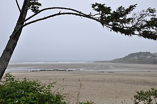
The Yachats Ocean Road State Natural Site is a state park in southern Lincoln County, Oregon, in the town of Yachats. It is administered by the Oregon Parks and Recreation Department. It is located on the Pacific Ocean coast, adjacent to the Oregon Coast Highway and the mouth of the Yachats River. The park is open for day use only, and offers scenic driving on a 1-mile (1.6 km) loop, and wildlife and surf viewing, but is backed on its landward side by low-intensity urban development.
The Yachats State Recreation Area is a state park in southern Lincoln County, Oregon, in the central district of the town of Yachats. It is administered by the Oregon Parks and Recreation Department. It is located on the Pacific Ocean coast, on the north side of the mouth of the Yachats River. The park is open for day use only, and offers wildlife and surf viewing, tidepools, fishing, and picnicking.
H. B. Van Duzer Forest State Scenic Corridor is a 12-mile (19 km) scenic driving route along Route 18 in Lincoln, Tillamook, and Polk counties in the U.S. state of Oregon that passes through a forested corridor. The Van Duzer Corridor stretches from northwestern Polk County to Lincoln City, passing through the Northern Oregon Coast Range.
Agate Beach State Recreation Site is a state park between Newport and Agate Beach in Lincoln County in the U.S. state of Oregon. It is administered by the Oregon Parks and Recreation Department.
D River State Recreation Site is a state park in the U.S. state of Oregon, administered by the Oregon Parks and Recreation Department. It is a sandy beach of the Pacific Ocean within central Lincoln City along the length of the 120-foot (37 m) long D River, one of the world's shortest rivers.
Devils Lake State Recreation Area is a state park in the U.S. state of Oregon, administered by the Oregon Parks and Recreation Department.
Fogarty Creek State Recreation Area is a state park in the U.S. state of Oregon, administered by the Oregon Parks and Recreation Department.
Gleneden Beach State Recreation Site is a state park administered by the Oregon Parks and Recreation Department in the U.S. state of Oregon. Located along the Pacific Ocean 7 miles (11 km) south of Lincoln City, it offers public beach access, picnicking, and fishing in a setting of shore pines, sandstone bluffs, and sand. The park is fee-free.
W. B. Nelson State Recreation Site is a state park in Lincoln County, western Oregon.
Lincoln Rock State Park is a public recreation area on the east side of the Columbia River's Lake Entiat, seven miles (11 km) north of Wenatchee and one mile upstream from the Rocky Reach Dam. The state park covers 86 acres (35 ha) opposite the cliff formation for which it is named. The park provides views of the south end of Swakane Canyon and of Turtle Rock Island in Lake Entiat, a 150-acre nature preserve that was isolated from the mainland when the lake formed in the 1960s. The park offers water activities, including fishing, boating, and swimming, in addition to facilities for picnicking, camping, hiking, and field sports. It is managed by the Washington State Parks and Recreation Commission under a lease agreement with the owners, the Chelan County Public Utility District.
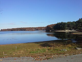
Lincoln Woods State Park is a public recreation area covering 627 acres (254 ha) around Olney Pond four miles (6.4 km) northwest of Pawtucket in the town of Lincoln, Rhode Island. The state park is known for its giant glacial boulders and the stony nature of its terrain which prevented most of the parkland from being used as farmland or for other development.
An outdoor bronze statue of Abraham Lincoln by Henry Kirke Brown is installed in Union Square in Manhattan, New York. The statue was sponsored by the Union League Club of New York.
Brian Booth State Park is a coastal recreational area located near Seal Rock, Lincoln County, Oregon United States, administered by the Oregon Parks and Recreation Department.. It consists of two major portions: Ona Beach State Park and Beaver Creek State Natural Area, which were merged in 2013. The park has beach access, kayaking, and hiking trails. The park is 886.32 acres and has an annual attendance of 247,772 people. Ona is known as a Chinook Jargon word for razor clam.
The Concert Grove is a section of Prospect Park, Brooklyn, New York City, that historically functioned as an outdoor music venue. It still serves as a sculpture garden lined with busts of musical figures, largely put up by German American Sängerfest participants and other cultural groups. The Concert Grove also includes the Concert Grove Pavilion, formerly known as the Oriental Pavilion, and adjoins a Lincoln sculpture facing the lake.