
San Lorenzo is a town and municipality of Puerto Rico located in the eastern central region, north of Patillas and Yabucoa; south of Gurabo; east of Caguas and Cayey; and west of Juncos and Las Piedras. San Lorenzo is spread over twelve barrios and San Lorenzo Pueblo. It is part of the San Juan-Caguas-Guaynabo Metropolitan Statistical Area.
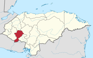
Intibucá is one of the 18 departments in the Republic of Honduras. Intibucá covers a total surface area of 1,186.1 square miles (3,072 km2). Its capital is the city of La Esperanza, in the municipality of La Esperanza.

Gurabo is a town and municipality in eastern Puerto Rico. It is located in the central eastern region, north of San Lorenzo; south of Trujillo Alto; east of Caguas; and west of Carolina and Juncos. Gurabo is spread over 9 barrios and Gurabo Pueblo. It is part of the San Juan-Caguas-Guaynabo Metropolitan Statistical Area.

Manatí is a city and municipality of Puerto Rico on the northern coast. It is north of Morovis and Ciales, east of Florida and Barceloneta, and west of Vega Baja. Manatí is has over 8 barrios and Manatí barrio-pueblo, the downtown area and the administrative center of the city. It is part of the San Juan-Caguas-Guaynabo Metropolitan Statistical Area.

Villalba, originally known as Villa Alba, is a town and municipality of Puerto Rico located in the central region, northeast of Juana Díaz; south of Orocovis; and west of Coamo. Villalba is spread over 6 barrios and Villalba Pueblo. It is part of the Ponce Metropolitan Statistical Area.
Isthmus Nahuatl is a Nahuatl dialect cluster spoken by about 30,000 people in Veracruz, Mexico. According to Ethnologue 16, the Cosoleacaque dialect is 84% intelligible with Pajapan, and 83% intelligible with Mecayapan.
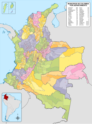
The municipalities of Colombia are decentralized subdivisions of the Republic of Colombia. Municipalities make up most of the departments of Colombia with 1,122 municipalities (municipios). Each one of them is led by a mayor (alcalde) elected by popular vote and represents the maximum executive government official at a municipality level under the mandate of the governor of their department which is a representative of all municipalities in the department; municipalities are grouped to form departments.

The Triqui or Trique are an Indigenous people of the western part of the Mexican state of Oaxaca, centered in the municipalities of Juxtlahuaca, Putla, and Tlaxiaco. They number around 23,000 according to Ethnologue surveys. The Triqui language is a Mixtecan language of Oto-Manguean genetic affiliation. Trique peoples are known for their distinctive woven huipiles, baskets, and morrales (handbags).

San Juan Bautista Tuxtepec, or simply referred to as Tuxtepec, is the head of the municipality by the same name and is the second most populous city of the Mexican state of Oaxaca. It is part of the Tuxtepec District of the Papaloapan Region. As of the 2020 census, the city is home to a population of 103,609 and 159,452 in the municipality, though census data are often under reported for various reasons.

El Cerrito is a town and municipality located in the Department of Valle del Cauca, Colombia. This is one of the 42 municipalities of the department.

José María Tranquilino Francisco de Jesús Velasco Gómez Obregón, generally known as José María Velasco, was a 19th-century Mexican polymath, most famous as a painter who made Mexican geography a symbol of national identity through his paintings. He was both one of the most popular artists of the time and internationally renowned. He received many distinctions such as the gold medal of the Mexican National Expositions of Bellas Artes in 1874 and 1876; the gold medal of the Philadelphia International Exposition in 1876, on the centenary of U.S. independence; and the medal of the Paris Universal Exposition in 1889, on the centenary of the outbreak of the French Revolution. His painting El valle de México is considered Velasco's masterpiece, of which he created seven different renditions. Of all the nineteenth-century painters, Velasco was the "first to be elevated in the post-Revolutionary period as an exemplar of nationalism."

Tlaxiaco is a city, and its surrounding municipality of the same name, in the Mexican state of Oaxaca. It is located in the Tlaxiaco District in the south of the Mixteca Region, with a population of about 17,450.
San Jose Villa de Allende is a town and municipal seat of the municipality of Villa de Allende. It is the fifth largest town in the municipality. It is located 70 kilometers to the west of the city of Toluca. Villa de Allende was named in honor of Ignacio Allende, a hero of the Mexican War of Independence.

Pinotepa Nacional is a city and seat of the municipality of the same name, in the Mexican state of Oaxaca. It is located in the Jamiltepec District in the west of the Costa Region. The name Pinotepa means "toward the crumbling hill" in Náhuatl.
Santa Catarina Juquila is a town in the State of Oaxaca, Mexico, and is the seat of the municipality also called Santa Catarina Juquila. It is part of the Juquila District in the center of the Costa Region. The name "Juquila" comes from "Xuhquililla", which means "Place of blue milkweed".
Santa María Jacatepec is a town and municipality located in the state of Oaxaca 11 km north of the Valle Nacional. "Jacatepec" comes from Nahuatl meaning 'on jackal hill.' It is part of the Tuxtepec District of the Papaloapan Region, and is only 30 meters above sea level.
La Genuina was a military uprising in Venezuela, led by General Luciano Mendoza. It took place in Bolívar state in September 1867, and was held against Juan Crisóstomo Falcón. He was followed by General Miguel Antonio Rojas in Aragua State and also by Pedro Arana in Carabobo State.