This table shows an overview of the protected heritage sites in the Flemish town Alken, Belgium . This list is part of Belgium's national heritage.
| Object | Status? | Year/architect | Town/section | Address | Coordinates | Number? | Image |
|---|---|---|---|---|---|---|---|
| Farmhouse with separate components (nl)(fr) | Alken | Alkerstraat 62 | 50°52′19″N5°19′13″E / 50.87198°N 5.32024°E | 31633 Info | |||
| Farmhouse with separate components (nl)(fr) | Alken | Blekkenbergstraat 37 | 50°54′23″N5°16′26″E / 50.90627°N 5.27401°E | 31635 Info | |||
| Castle Brandepoel (nl)(fr) | Alken | Brandepoelstraat 37 | 50°52′12″N5°14′44″E / 50.87012°N 5.24547°E | 31636 Info | |||
| Castle Brandepoel (nl)(fr) | Alken | Brandepoelstraat 38 | 50°52′12″N5°14′44″E / 50.87012°N 5.24547°E | 31636 Info | |||
| Farm Brandepoel (nl)(fr) | Alken | Brandepoelstraat 23 | 50°52′04″N5°14′49″E / 50.86779°N 5.24687°E | 31637 Info | |||
| Residential farm (nl)(fr) | Alken | Bulsstraat 12 | 50°52′37″N5°20′45″E / 50.87702°N 5.34573°E | 31638 Info | |||
| Farm (nl)(fr) | Alken | Bulsstraat 85 | 50°52′17″N5°20′58″E / 50.87149°N 5.34957°E | 31639 Info | |||
| Closed farm (nl)(fr) | Alken | Bulsstraat 59 | 50°52′27″N5°20′56″E / 50.87412°N 5.34878°E | 31640 Info | |||
| Farm Timmersmans (nl)(fr) | Alken | Bulsstraat 116 | 50°52′03″N5°21′00″E / 50.86737°N 5.35007°E | 31641 Info | |||
| Farmhouse (nl)(fr) | Alken | Doktoorstraat 1 | 50°52′26″N5°18′14″E / 50.87402°N 5.30400°E | 31642 Info | |||
| House (nl)(fr) | Alken | Dorpsstraat 2 | 50°52′35″N5°18′26″E / 50.87649°N 5.30718°E | 31643 Info | |||
| Chapel of 1962 (nl)(fr) | Alken | Grootstraat | 50°52′49″N5°20′14″E / 50.88041°N 5.33714°E | 31644 Info | |||
| Farmhouse with separate components (nl)(fr) | Alken | Grootstraat 90 | 50°52′44″N5°19′27″E / 50.87895°N 5.32410°E | 31645 Info | |||
| House (nl)(fr) | Alken | Grootstraat 102 | 50°52′45″N5°19′32″E / 50.87917°N 5.32550°E | 31646 Info | |||
| Semi-closed farm (nl)(fr) | Alken | Grootstraat 114 | 50°52′46″N5°19′39″E / 50.87946°N 5.32739°E | 31647 Info | |||
| Closed farm (nl)(fr) | Alken | Grootstraat 133 | 50°52′48″N5°19′43″E / 50.88002°N 5.32864°E | 31649 Info | |||
| Remains of a long farm complex (nl)(fr) | Alken | Grootstraat 194 | 50°52′49″N5°20′20″E / 50.88029°N 5.33887°E | 31650 Info | |||
| Castle of Corswarem (nl)(fr) | Alken | Hameestraat 65 | 50°52′04″N5°18′02″E / 50.86772°N 5.30056°E | 31651 Info | |||
| Long stretch of farm (nl)(fr) | Alken | Heiligenbornstraat 47 | 50°52′26″N5°15′04″E / 50.87381°N 5.25117°E | 31652 Info | |||
| St. George's Chapel (nl)(fr) | Alken | Hemelsveldstraat | 50°52′05″N5°16′33″E / 50.86815°N 5.27574°E | 31653 Info | |||
| Semi-closed farm (nl)(fr) | Alken | Hemelsveldstraat 72 | 50°52′02″N5°16′22″E / 50.86710°N 5.27291°E | 31654 Info | |||
| Farmhouse with separate components (nl)(fr) | Alken | Hendrikstraat 66 | 50°52′30″N5°16′39″E / 50.87505°N 5.27743°E | 31655 Info | |||
| Closed farm (nl)(fr) | Alken | Hendrikstraat 93 | 50°52′35″N5°16′26″E / 50.87628°N 5.27387°E | 31656 Info | |||
| Farmhouse with separate components (nl)(fr) | Alken | Hendrikstraat 104 | 50°52′39″N5°16′23″E / 50.87751°N 5.27305°E | 31657 Info | |||
| Farm Rodenhof (nl)(fr) | Alken | Hendrikstraat 129 | 50°52′40″N5°16′15″E / 50.87789°N 5.27077°E | 31658 Info | |||
| Parish Church St. Aldegondis (nl)(fr) | Alken | Hoogdorpsstraat | 50°52′32″N5°18′26″E / 50.87554°N 5.30736°E | 31659 Info |  | ||
| section house (nl)(fr) | Alken | Hoogdorpsstraat 38 | 50°52′31″N5°18′21″E / 50.87528°N 5.30581°E | 31660 Info | |||
| House (nl)(fr) | Alken | Hoogsimsestraat 2 | 50°51′49″N5°17′35″E / 50.86360°N 5.29318°E | 31661 Info | |||
| Closed farm (nl)(fr) | Alken | Hoogsimsestraat 75 | 50°51′30″N5°17′50″E / 50.85845°N 5.29718°E | 31662 Info | |||
| Restored farmhouse (nl)(fr) | Alken | Hulzenstraat 140 | 50°52′36″N5°15′32″E / 50.87679°N 5.25879°E | 31663 Info | |||
| Farmhouse with separate components (nl)(fr) | Alken | Hulzenveldstraat 21 | 50°52′42″N5°15′29″E / 50.87830°N 5.25801°E | 31664 Info | |||
| Chapel (nl)(fr) | Alken | Klameerstraat | 50°51′28″N5°17′51″E / 50.85771°N 5.29745°E | 31665 Info | |||
| L-shaped farmhouse (nl)(fr) | Alken | Klameerstraat 20 | 50°51′50″N5°18′20″E / 50.86380°N 5.30560°E | 31666 Info | |||
| Closed farm (nl)(fr) | Alken | Klinkstraat 38 | 50°52′57″N5°19′39″E / 50.88260°N 5.32756°E | 31667 Info | |||
| Farm Diepers (nl)(fr) | Alken | Klinkstraat 56 | 50°52′54″N5°19′53″E / 50.88175°N 5.33150°E | 31668 Info | |||
| Closed farm (nl)(fr) | Alken | Klinkstraat 57 | 50°52′56″N5°19′51″E / 50.88226°N 5.33076°E | 31669 Info | |||
| Knipscheer Chapel (nl)(fr) | Alken | Knipscheerstraat | 50°51′28″N5°17′12″E / 50.85780°N 5.28673°E | 31670 Info | |||
| Farmhouse with separate components (nl)(fr) | Alken | Knipscheerstraat 87 | 50°51′27″N5°17′12″E / 50.85752°N 5.28663°E | 31671 Info | |||
| Farm (nl)(fr) | Alken | Knipscheerstraat 92 | 50°51′31″N5°17′13″E / 50.85848°N 5.28683°E | 31672 Info | |||
| Corner (nl)(fr) | Alken | Laagdorp 1 | 50°52′33″N5°18′30″E / 50.87575°N 5.30827°E | 31673 Info | |||
| Ruin of a road chapel (nl)(fr) | Alken | Laagsimsestraat | 50°51′58″N5°17′27″E / 50.86604°N 5.29093°E | 31674 Info | |||
| Closed farm (nl)(fr) | Alken | Laagsimsestraat 98 | 50°52′16″N5°17′19″E / 50.87121°N 5.28855°E | 31675 Info | |||
| Guild Hall of 1914 (nl)(fr) | Alken | Hoogdorpsstraat 5 | 50°52′29″N5°18′21″E / 50.87480°N 5.30587°E | 31676 Info | |||
| Long stretch of farm (nl)(fr) | Alken | Leemkuilstraat 101 | 50°52′16″N5°19′45″E / 50.87100°N 5.32911°E | 31678 Info | |||
| Spleethoeve (nl)(fr) | Alken | Lindestraat 21 | 50°53′03″N5°16′18″E / 50.88408°N 5.27177°E | 31679 Info | |||
| Semi-closed farm (nl)(fr) | Alken | Lindestraat 93 | 50°53′32″N5°16′04″E / 50.89225°N 5.26771°E | 31680 Info | |||
| Semi-closed farm (nl)(fr) | Alken | Lindestraat 149 | 50°53′49″N5°15′41″E / 50.89706°N 5.26149°E | 31681 Info | |||
| U-shaped farm (nl)(fr) | Alken | Lindestraat 164 | 50°53′50″N5°15′50″E / 50.89720°N 5.26383°E | 31682 Info | |||
| L-shaped farmhouse (nl)(fr) | Alken | Lindestraat 195 | 50°54′05″N5°15′28″E / 50.90142°N 5.25780°E | 31683 Info | |||
| Closed farm of 1886 (nl)(fr) | Alken | Lindestraat 210 | 50°54′04″N5°15′34″E / 50.90100°N 5.25955°E | 31684 Info | |||
| Long stretch of farm (nl)(fr) | Alken | Meerdegatstraat 17 | 50°52′50″N5°19′00″E / 50.88051°N 5.31676°E | 31687 Info | |||
| House (nl)(fr) | Alken | Meerdegatstraat 19 | 50°52′51″N5°19′00″E / 50.88081°N 5.31661°E | 31688 Info | |||
| Closed farm (nl)(fr) | Alken | Meerdegatstraat 49 | 50°52′59″N5°18′54″E / 50.88314°N 5.31507°E | 31689 Info | |||
| Long stretch of farm (nl)(fr) | Alken | Meerdegatstraat 114 | 50°53′10″N5°18′38″E / 50.88624°N 5.31048°E | 31690 Info | |||
| Closed farm (nl)(fr) | Alken | Meerdegatstraat 116 | 50°53′11″N5°18′36″E / 50.88645°N 5.31005°E | 31691 Info | |||
| Farmhouse with separate components (nl)(fr) | Alken | Meerdegatstraat 138 | 50°53′19″N5°18′31″E / 50.88849°N 5.30871°E | 31692 Info | |||
| Green Mill (nl)(fr) | Alken | Meerdegatstraat 155 | 50°53′25″N5°18′23″E / 50.89038°N 5.30649°E | 31693 Info | |||
| Farmhouse with separate components (nl)(fr) | Alken | Molenstraat | 50°53′47″N5°17′45″E / 50.89639°N 5.29596°E | 31694 Info | |||
| Closed farm Black Mining (nl)(fr) | Alken | Molenstraat 24 | 50°53′48″N5°17′52″E / 50.89663°N 5.29787°E | 31695 Info | |||
| New Mill (nl)(fr) | Alken | Molenstraat 58 | 50°54′02″N5°17′02″E / 50.90044°N 5.28393°E | 31696 Info | |||
| Chapel of Our Lady Hope of Hope Release (nl)(fr) | Alken | Motstraat | 50°52′00″N5°18′34″E / 50.86668°N 5.30934°E | 31697 Info | |||
| Corner Building (nl)(fr) | Alken | Laagdorp 2 | 50°52′31″N5°18′29″E / 50.87527°N 5.30814°E | 31698 Info | |||
| Long stretch of farm (nl)(fr) | Alken | Oftingenstraat 11 | 50°53′08″N5°18′54″E / 50.88564°N 5.31497°E | 31699 Info | |||
| Castle Leva (nl)(fr) | Alken | O. L. Vrouwstraat 40 | 50°53′41″N5°16′52″E / 50.89479°N 5.28103°E | 31700 Info |  | ||
| Motte (nl)(fr) | Alken | O. L. Vrouwstraat | 50°53′35″N5°16′44″E / 50.89306°N 5.27883°E | 31701 Info | |||
| Closed farm (nl)(fr) | Alken | O. L. Vrouwstraat 68 | 50°53′42″N5°16′47″E / 50.89500°N 5.27967°E | 31702 Info | |||
| Closed farm (nl)(fr) | Alken | Oude Baan 87 | 50°53′06″N5°17′04″E / 50.88503°N 5.28449°E | 31703 Info | |||
| Farmhouse Groot-Peteren (nl)(fr) | Alken | Rechtstraat 61 | 50°52′19″N5°20′11″E / 50.87193°N 5.33637°E | 31704 Info | |||
| Village house (nl)(fr) | Alken | Ridderstraat 7 | 50°52′32″N5°18′19″E / 50.87559°N 5.30519°E | 31705 Info | |||
| House of a large farm (nl)(fr) | Alken | Ridderstraat 10 | 50°52′34″N5°18′18″E / 50.87620°N 5.30498°E | 31706 Info | |||
| Long stretch of farm (nl)(fr) | Alken | Sassenbroekstraat 35 | 50°53′00″N5°19′19″E / 50.88343°N 5.32196°E | 31707 Info | |||
| Farmhouse with separate components (nl)(fr) | Alken | Schoenbeekstraat 21 | 50°52′14″N5°20′31″E / 50.87046°N 5.34203°E | 31708 Info | |||
| Closed farm (nl)(fr) | Alken | Snoekstraat 24 | 50°51′51″N5°18′27″E / 50.86427°N 5.30755°E | 31709 Info | |||
| Rectory (nl)(fr) | Alken | St. Aldegondislaan 1 | 50°52′31″N5°18′24″E / 50.87521°N 5.30668°E | 31710 Info | |||
| Alken railway station (nl)(fr) | Alken | Stationsplein 2 | 50°53′12″N5°17′33″E / 50.88676°N 5.29263°E | 31711 Info | 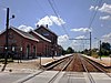 | ||
| Brewery Alken (nl)(fr) | Alken | Stationsstraat 2 | 50°52′43″N5°18′26″E / 50.87863°N 5.30710°E | 31712 Info |  | ||
| U-shaped farm (nl)(fr) | Alken | Stationsstraat 7 | 50°52′40″N5°18′21″E / 50.87768°N 5.30591°E | 31713 Info | |||
| House (nl)(fr) | Alken | Stationsstraat 99 | 50°53′06″N5°17′44″E / 50.88494°N 5.29559°E | 31714 Info | |||
| Brick chapel (nl)(fr) | Alken | Steenweg | 50°51′50″N5°14′54″E / 50.86385°N 5.24838°E | 31715 Info | |||
| The Manor De Geuzentempel (nl)(fr) | Alken | Steenweg 142 | 50°53′16″N5°17′08″E / 50.88790°N 5.28547°E | 31716 Info | |||
| Long stretch of farm (nl)(fr) | Alken | Steenweg 114 | 50°53′23″N5°17′25″E / 50.88964°N 5.29040°E | 31718 Info | |||
| Castle farm De Oude Vlieg (nl)(fr) | Alken | Steenweg 239 | 50°52′49″N5°16′29″E / 50.88035°N 5.27460°E | 31719 Info | |||
| Villa of 1911 (nl)(fr) | Alken | Steenweg 276 | 50°52′37″N5°16′03″E / 50.87690°N 5.26752°E | 31720 Info | |||
| Long stretch of farm (nl)(fr) | Alken | Steenweg 334 | 50°52′20″N5°15′37″E / 50.87225°N 5.26026°E | 31721 Info | |||
| Farmhouse with separate components (nl)(fr) | Alken | Steenweg 352 | 50°52′16″N5°15′31″E / 50.87103°N 5.25861°E | 31722 Info | |||
| Closed farm (nl)(fr) | Alken | Steenweg 361 | 50°52′16″N5°15′36″E / 50.87122°N 5.26007°E | 31723 Info | |||
| Closed farm (nl)(fr) | Alken | Steenweg 363 | 50°52′16″N5°15′36″E / 50.87122°N 5.26007°E | 31723 Info | |||
| Long stretch of farm (nl)(fr) | Alken | Steenweg 368 | 50°52′12″N5°15′24″E / 50.87009°N 5.25679°E | 31724 Info | |||
| Closed farm (nl)(fr) | Alken | Vliegstraat 35 | 50°52′31″N5°16′55″E / 50.87524°N 5.28205°E | 31725 Info | |||
| Closed farm (nl)(fr) | Alken | Vliegstraat 89 | 50°52′43″N5°16′34″E / 50.87870°N 5.27618°E | 31726 Info | |||
| Long stretch of farm (nl)(fr) | Alken | Wolfstraat 6 | 50°51′52″N5°16′09″E / 50.86447°N 5.26912°E | 31727 Info | |||
| Farmhouse with separate components (nl)(fr) | Alken | Wolfstraat 57 | 50°51′59″N5°15′48″E / 50.86640°N 5.26347°E | 31728 Info | |||
| Mansion Zeegershof (nl)(fr) | Alken | Koosterstraat 51 | 50°54′13″N5°16′47″E / 50.90367°N 5.27962°E | 31729 Info | |||
| Immaculate Conception Parish (nl)(fr) | Alken | Parkstraat | 50°53′54″N5°16′34″E / 50.89841°N 5.27613°E | 31730 Info |  | ||
| Castle d'Erckenteel (nl)(fr) | Alken | Parkstraat 9 | 50°53′58″N5°16′36″E / 50.89955°N 5.27668°E | 31731 Info | |||
| Parish church of Saint George (nl)(fr) | Alken | St. Jorisstraat | 50°52′18″N5°16′19″E / 50.87156°N 5.27206°E | 84068 Info |  | ||
| Farm in timber framing (nl)(fr) | Alken | Stoukstraat 44 | 50°51′30″N5°15′34″E / 50.85826°N 5.25949°E | 200369 Info | |||
| Farm in timber framing (nl)(fr) | Alken | Vliegstraat 93 | 200381 Info |