This table shows an overview of the protected heritage sites in the Walloon town Bouillon . This list is part of Belgium's national heritage.
| Object | Year/architect | Town/section | Address | Coordinates | Number? | Image |
|---|---|---|---|---|---|---|
| Old castle-fortress of Bouillon, the walls, a fire escape, the bastion of Burgundy and the building and keep for the ensemble of these buildings and surrounding areas (nl)(fr) | Bouillon Bouillon | 49°47′34″N5°03′55″E / 49.792756°N 5.065301°E | 84010-CLT-0001-01 Info |  | ||
| The bastion of Brittany and the bastion of the Dauphin (nl)(fr) | Bouillon Bouillon | 49°47′51″N5°04′01″E / 49.797538°N 5.067021°E | 84010-CLT-0003-01 Info | 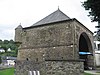 | ||
| Ensemble of two mansions in the vicinity of the former castle of Bouillon and the surrounding areas (nl)(fr) | Bouillon Bouillon | 49°47′41″N5°03′55″E / 49.794632°N 5.065376°E | 84010-CLT-0005-01 Info | |||
| Mansion near the castle of Bouillon (nl)(fr) | Bouillon Bouillon | Rue de Brutz 39 | 49°47′43″N5°03′59″E / 49.795382°N 5.066505°E | 84010-CLT-0006-01 Info | 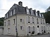 | |
| Mansion near the castle of Bouillon (nl)(fr) | Bouillon Bouillon | place des Champs-Prévôt n°10 | 49°47′49″N5°03′59″E / 49.796951°N 5.066376°E | 84010-CLT-0007-01 Info |  | |
| Ducal Museum: the two buildings with collections (nl)(fr) | Bouillon Bouillon | Place Ducale | 49°47′40″N5°04′05″E / 49.794383°N 5.068077°E | 84010-CLT-0008-01 Info |  | |
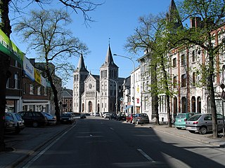
| Town hall (nl)(fr) | Bouillon Bouillon | Place Ducale | 49°47′41″N5°04′05″E / 49.794708°N 5.068038°E | 84010-CLT-0010-01 Info | 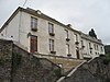 | |
| Vauban barracks: facades and roofs (nl)(fr) | Bouillon Bouillon | boulevard Heynen n°16 | 49°47′49″N5°04′09″E / 49.797057°N 5.069282°E | 84010-CLT-0011-01 Info |  | |
| Extending the classification of barracks of Vauban (nl)(fr) | Bouillon Bouillon | 49°47′47″N5°04′10″E / 49.796476°N 5.069434°E | 84010-CLT-0012-01 Info | |||
| Rural building in La Cornette at Les Hayons (now a farm) (nl)(fr) | Les Hayons Bouillon | Rue de la Cornette 55 | 49°48′50″N5°08′46″E / 49.813771°N 5.146018°E | 84010-CLT-0013-01 Info | ||
| Watering hole (nl)(fr) | Noirefontaine Bouillon | Rue de la Sentinelle | 49°49′00″N5°05′25″E / 49.816570°N 5.090196°E | 84010-CLT-0014-01 Info |  | |
| Farm in Frahan (nl)(fr) | Rochehaut Bouillon | n°22, Frahan | 49°50′03″N5°00′03″E / 49.834171°N 5.000886°E | 84010-CLT-0016-01 Info | ||
| Bend of the Semois river in Frahan and setting of conservation (nl)(fr) | Rochehaut Bouillon | 49°50′24″N4°59′59″E / 49.839971°N 4.999841°E | 84010-CLT-0017-01 Info |  | ||
| Set of St. Firminuskerk, surrounding wall of the churchyard and ensemble of the church, the graveyard and surrounding wall (nl)(fr) | Rochehaut Bouillon | 49°50′25″N5°00′22″E / 49.840253°N 5.006028°E | 84010-CLT-0021-01 Info | 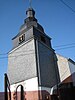 | ||
| Part of the ensemble of the Tombeau du Géant, on the territory of the municipalities Rochehaut and Ucimont, and the places called "Les Grandes Falloiges, les Petites Falloiges, Ravers, Queue de Terme, Fond d'Ucimont, Pres de la Semois, Pré de la Bouche à l'eau, the Assences Pigerue, Pre Saint-Firmin, Pigerue la, le Fretis, Goutai the Wires, Gouttel la, la Rigonel, Scoticainay, la Wire des Quoees, the Couplemou, la Virée du Ru , le Ru " (nl)(fr) | Rochehaut en Ucimont Bouillon | 49°50′02″N5°00′49″E / 49.833889°N 5.013720°E | 84010-CLT-0025-01 Info | 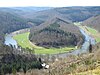 | ||
| Part of the site of Tombeau du Géant, on the territory of the municipalities Ucimont, Botassart and Corbion and places Merleux Han, le cul de Merleux Han Noires Eaux, Tibetrix, the Pres Germovez, Germovez, Lovete, Loquet, Devant le Mont , Sarsucot (nl)(fr) | Corbion en Ucimont Bouillon | 49°48′30″N5°00′29″E / 49.808248°N 5.008191°E | 84010-CLT-0026-01 Info |  | ||
| Part of the site of Tomeau du Geant in Sensenruth, Ucimont and Corbion (nl)(fr) | Corbion, Sensenruth en Ucimont Bouillon | 49°49′23″N5°01′50″E / 49.822979°N 5.030689°E | 84010-CLT-0027-01 Info |  | ||
| Part of the ensemble of the Tombeau du Géant and includes the places, "L'Orient-Traicot, Tailles des Augustins, l'Epinne, Clernot, Au-dessus the Clernot, l'Ecaillire, du Pré Plane" (nl)(fr) | Corbion Bouillon | 49°48′14″N5°01′29″E / 49.804026°N 5.024737°E | 84010-CLT-0028-01 Info | 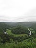 | ||
| Moulin de Rivage at the Tombeau du Géant, facades and roofs, machine room, channel water to the old mill wheel (nl)(fr) | Bouillon | 49°49′04″N5°02′35″E / 49.817697°N 5.042981°E | 84010-CLT-0029-01 Info | 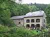 | ||
| Roche aux Fees and the adjacent area of the Semois called Vanne des Bains (nl)(fr) | Bouillon | 49°47′24″N5°03′53″E / 49.790124°N 5.064723°E | 84010-CLT-0031-01 Info | 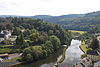 | ||
| Chapel of the Immaculate Conception and the wall around the cemetery (nl)(fr) | Bouillon | 49°49′18″N5°02′54″E / 49.821706°N 5.048344°E | 84010-CLT-0033-01 Info | 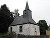 | ||
| Church of Saint-Lambert and the ensemble of the building and its surroundings (nl)(fr) | Bouillon | 49°49′31″N5°04′22″E / 49.825345°N 5.072720°E | 84010-CLT-0034-01 Info | 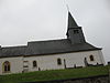 | ||
| House of the commander, also known as the home of the Provost, located between Boulevard Heynen and Champ Prévôt: facades and roofs and walls of the walled garden (nl)(fr) | Bouillon Bouillon | 49°47′50″N5°04′03″E / 49.797271°N 5.067400°E | 84010-CLT-0035-01 Info |  | ||
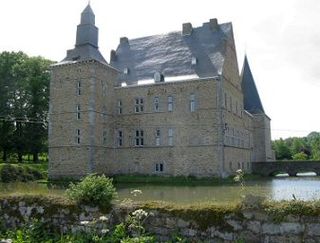
| Castle farm of Dohan: facades and roofs of buildings from the 18th century, large lounge and staircase, and the ensemble of the building and its surroundings (nl)(fr) | Dohan Bouillon | Dohan Haut | 49°47′42″N5°08′31″E / 49.794962°N 5.141898°E | 84010-CLT-0036-01 Info | ||
| House (nl)(fr) | Rochehaut Bouillon | Rue de la Cense 19 | 49°50′24″N5°00′15″E / 49.840109°N 5.004168°E | 84010-CLT-0037-01 Info | ||
| Priory of the Sepulchrines: facades and roofs (nl)(fr) | Bouillon Bouillon | Rue du Collège | 49°47′37″N5°04′10″E / 49.793623°N 5.069520°E | 84010-CLT-0038-01 Info |  | |
| House called "la Poulie" (old gatekeepers house), excluding contemporary extensions (nl)(fr) | Bouillon Bouillon | Rue de la Poulie 6, Bouillon | 49°47′40″N5°03′56″E / 49.79433°N 5.0655°E | 84010-CLT-0039-01 Info |  | |
| Farm in Frahan (nl)(fr) | Rochehaut Bouillon | n°23, gehucht Frahan | 49°50′03″N5°00′03″E / 49.834243°N 5.000781°E | 84010-CLT-0040-01 Info | ||
| Old castle-fortress of Bouillon, the walls, the fire escape, and the main bastion of Burgundy, and the ensemble of buildings and surrounding areas (nl)(fr) | Bouillon Bouillon | 49°47′34″N5°03′55″E / 49.792756°N 5.065301°E | 84010-PEX-0001-01 Info |  | ||
| Bend of the Semois in Frahan (nl)(fr) | Rochehaut Bouillon | 49°50′24″N4°59′59″E / 49.839971°N 4.999841°E | 84010-PEX-0002-01 Info |  |