List of protected heritage sites in Braine-le-Comte

Last updated

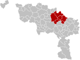
This table shows an overview of the protected heritage sites in the Walloon town Braine-le-Comte . This list is part of Belgium's national heritage.

Object
Year/architect
Town/section
Address
Coordinates
Number?
Image
Forest "Bois de la Houssière" (nl)(fr)
's Gravenbrakel 50°37′15″N4°10′32″E / 50.620777°N 4.175633°E / 50.620777; 4.175633

55004-CLT-0001-01  Info

4 prehistoric tombs (nl)(fr)
's Gravenbrakel 50°37′13″N4°11′56″E / 50.620270°N 4.198845°E / 50.620270; 4.198845

55004-CLT-0002-01  Info

Old church of the Dominicans (nl)(fr)
's Gravenbrakel 50°36′35″N4°08′07″E / 50.609854°N 4.135386°E / 50.609854; 4.135386

55004-CLT-0003-01  Info

Oude kerk van de Dominicanen Braine-le-Comte E2.JPG
Oude kerk van de Dominicanen
Church of Saint-Gery (nl)(fr)
's Gravenbrakel 50°36′46″N4°08′13″E / 50.612904°N 4.137078°E / 50.612904; 4.137078

55004-CLT-0004-01  Info

Kerk Saint-Gery Braine-le-Comte JPG00.jpg
Kerk Saint-Géry
Old Town Hall, also known as the Hotel d'Arne Berg called main front facade and roof (nl)(fr)
's Gravenbrakel 50°36′38″N4°08′12″E / 50.610609°N 4.136668°E / 50.610609; 4.136668

55004-CLT-0005-01  Info

Oude raadhuis, ook wel Hotel d'Arnenberg genoemd: hoofdgevel en voorzijde dak Braine-le-Comte H1.JPG
Oude raadhuis, ook wel Hôtel d'Arnenberg genoemd: hoofdgevel en voorzijde dak
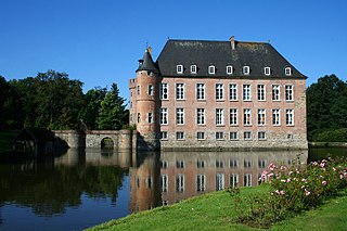
Castle of Salmon Sart and surroundings (nl)(fr)
's Gravenbrakelchaussée de Mons n° 128-130 50°35′32″N4°05′54″E / 50.592154°N 4.098273°E / 50.592154; 4.098273

55004-CLT-0006-01  Info

Kasteel van Salmonsart en omgeving Chateau de Salmonsart 2020.jpg
Kasteel van Salmonsart en omgeving
The remains of the ancient ramparts of the town of Braine-le-Comte, namely the three semicircular towers rose Larcee and another semicircular tower located in "rue des Fosses-Bass" (nl)(fr)
's Gravenbrakel 50°36′37″N4°08′19″E / 50.610186°N 4.138524°E / 50.610186; 4.138524

55004-CLT-0007-01  Info

Ensemble of the church Saint-Géry and surrounding wall (nl)(fr)
Ronquieres 's Gravenbrakel 50°36′32″N4°13′17″E / 50.608888°N 4.221401°E / 50.608888; 4.221401

55004-CLT-0010-01  Info

Ensemble van de kerk Saint-Gery en omliggende muur RonquieresChurch.jpg
Ensemble van de kerk Saint-Géry en omliggende muur
St. Martin's Church (nl)(fr)
Steenkerke 's Gravenbrakel 50°38′33″N4°04′09″E / 50.642623°N 4.069092°E / 50.642623; 4.069092

55004-CLT-0012-01  Info

Kerk Saint-Martin SteenkerqueEgliseChoeur.JPG
Kerk Saint-Martin
Former convent of the Dominicans: facades and roofs and the ensemble of these buildings and the environment (nl)(fr)
's Gravenbrakel 50°36′34″N4°08′08″E / 50.609534°N 4.135661°E / 50.609534; 4.135661

55004-CLT-0013-01  Info

Voormalig klooster van de Dominicanen: gevels en daken en het ensemble van deze gebouwen en de omgeving Couvent des Dominicains.jpg
Voormalig klooster van de Dominicanen: gevels en daken en het ensemble van deze gebouwen en de omgeving
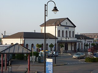
Station: facades and roofs and row of trees (nl)(fr)
's GravenbrakelPlace René Branquart 50°36′21″N4°08′18″E / 50.605759°N 4.138225°E / 50.605759; 4.138225

55004-CLT-0014-01  Info

Kiosk Grand 'Place (nl)(fr)
's GravenbrakelGrand' Place 50°36′38″N4°08′09″E / 50.610592°N 4.135913°E / 50.610592; 4.135913

55004-CLT-0016-01  Info

Kiosk Grand' Place Braine-le-Comte JPG02.jpg
Kiosk Grand' Place
Chapel Notre-Dame du Refuge (nl)(fr)
's Gravenbrakelrue de Turenne, n° 1 (M) et alentours (S) 50°38′13″N4°04′09″E / 50.637038°N 4.069139°E / 50.637038; 4.069139

55004-CLT-0017-01  Info

Chapel Notre-Dame de Grâce and environment (nl)(fr)
's Gravenbrakel 50°35′54″N4°11′24″E / 50.598462°N 4.189981°E / 50.598462; 4.189981

55004-CLT-0018-01  Info

Facade, roof and machinery of the mill called "Moulin de Cambron et d'Arenberg" environment and the river at the rear of the building (nl)(fr)
's Gravenbrakel 50°36′29″N4°13′16″E / 50.608047°N 4.220996°E / 50.608047; 4.220996

55004-CLT-0019-01  Info

Entire facade and roof, including the chassis, woodwork, ironwork of the house "Art Nouveau" (nl)(fr)
's GravenbrakelRue Neuman n°51 50°36′36″N4°08′22″E / 50.609937°N 4.139545°E / 50.609937; 4.139545

55004-CLT-0020-01  Info

Chapel of Bon Dieu de Pitie and the rock of Chenu (nl)(fr)
's Gravenbrakel 50°36′29″N4°13′34″E / 50.608178°N 4.225981°E / 50.608178; 4.225981

55004-CLT-0021-01  Info

The disused clay pit in one place "le Grand Bois" (nl)(fr)
's GravenbrakelHennuyères 50°39′03″N4°11′27″E / 50.650966°N 4.190814°E / 50.650966; 4.190814

55004-CLT-0022-01  Info

Sand quarry of Planois (extending woods of la Houssière) (nl)(fr)
Hennuyères 's Gravenbrakel 50°37′46″N4°11′05″E / 50.629466°N 4.184786°E / 50.629466; 4.184786

55004-CLT-0023-01  Info

Entire facade and roof, including the chassis, woodwork, ironwork of the house "Art Nouveau" (nl)(fr)
's GravenbrakelRue Neuman n°53 50°36′36″N4°08′23″E / 50.609979°N 4.139622°E / 50.609979; 4.139622

55004-CLT-0024-01  Info

Entire facade and roof, including the chassis, woodwork, ironwork of the house "Art Nouveau" (nl)(fr)
's GravenbrakelRue Neuman n°55 50°36′36″N4°08′23″E / 50.610010°N 4.139684°E / 50.610010; 4.139684

55004-CLT-0025-01  Info

Entire facade and roof, including the chassis, woodwork, ironwork of the house "Art Nouveau" (nl)(fr)
's GravenbrakelRue Neuman n°57 50°36′36″N4°08′23″E / 50.610053°N 4.139747°E / 50.610053; 4.139747

55004-CLT-0026-01  Info

Entire facade and roof, including the chassis, woodwork, ironwork of the house "Art Nouveau" (nl)(fr)
's GravenbrakelRue Neuman n°59 50°36′36″N4°08′23″E / 50.610088°N 4.139804°E / 50.610088; 4.139804

55004-CLT-0027-01  Info

Entire facade and roof, including the chassis, woodwork, ironwork of the house "Art Nouveau" (nl)(fr)
's GravenbrakelRue Neuman n°61 50°36′36″N4°08′24″E / 50.610117°N 4.139864°E / 50.610117; 4.139864

55004-CLT-0028-01  Info

Entire facade and roof, including the chassis, woodwork, ironwork of the house "Art Nouveau" (nl)(fr)
's GravenbrakelRue Neuman n°63 50°36′37″N4°08′24″E / 50.610152°N 4.139932°E / 50.610152; 4.139932

55004-CLT-0029-01  Info

See also

Related Research Articles

Braine-le-Comte Municipality in French Community, Belgium

Braine-le-Comte is a Walloon municipality located in the Belgian province of Hainaut. On January 1, 2006, Braine-le-Comte had a total population of 20,305. The total area is 84.68 square kilometres (32.70 sq mi) which gives a population density of 240 inhabitants per km².

Brussels Central Station railway/metro station in Brussels, Belgium

Brussels Central Station is a railway and metro station in central Brussels, Belgium. It is the second busiest railway station in Belgium and one of three principal railway stations in Brussels, together with Brussels-South and Brussels-North. First completed in 1952 after protracted delays caused by economic difficulties and World War II, it is the newest of Brussels' main rail hubs.

Brussels-South railway station railway station in Belgium

Brussels-South is one of the three major railway stations in Brussels and the busiest station in Belgium. It is located on the territory of the municipality of Saint-Gilles/Sint-Gillis. The station is connected to the Gare du Midi/Zuidstation station of the Brussels metro system.

Arrondissement of Soignies Arrondissement of Belgium in Walloon Region

The Arrondissement of Soignies is one of the seven administrative arrondissements in the Province of Hainaut, Belgium.

The Alatac was an automobile built by Automobiles Catala of Braine-le-Comte, Belgium, from 1913 to 1914.

Braine may refer to:

Brussels-North railway station railway station in Belgium

Brussels-North is one of the three major railway stations in Brussels (Belgium); the other two are Brussels-Central and Brussels-South. The station's bilingual French–Dutch name is generally translated to Brussels-North. Every regular domestic and international train passing there has a planned stop. The station has 200,000 passengers per week, mainly commuters.

Accident on the Rampe de Laffrey (1973) road accident in France

The accident on the Rampe de Laffrey on July 18, 1973, remains, as of 2017, the worst to ever have occurred along that stretch of roadway, among the worst in France. A bus was carrying Belgian pilgrims from Braine-le-Comte returning from a visit to the shrine of Our Lady of La Salette; it missed a curve at the base of the road, near its intersection with the bridge over the Romanche, and overturned. Forty-three people were killed and six injured in the resulting crash. After the crash the mayor of Laffrey condemned the route as being particularly dangerous, as it had already claimed over one hundred lives over the previous quarter-century.

Braine Castle castle in Braine-le-Château, Belgium

Braine Castle is a castle in Braine-le-Château, Walloon Brabant, Belgium.

Leuven railway station railway station in Belgium

Leuven is the main railway station in the Belgian city of Leuven, in Flemish Brabant. The station is operated by the national railway company NMBS and is located on railway line 36.

Braine-le-Comte railway station railway station in Belgium

Braine-le-Comte is a railway station in the town of Braine-le-Comte, Hainaut, Belgium. The station opened on 31 October 1841 and is located on the 96, 117 and 123. The train services are operated by National Railway Company of Belgium (NMBS).

Centre region, Hainaut area in Belgium

The Centre or the Région du Centre is a region within the province of Hainaut in Wallonia, Belgium. It is located between the cities of Mons, Charleroi, Thuin and Brabant.

Mechelen railway station railway station in Belgium

Mechelen is a railway station in the city of Mechelen, Antwerp, Belgium. The station opened on 5 May 1835 on the Lines 25, 27 and 53.

Vilvoorde railway station railway station in Belgium

Vilvoorde is a railway station in the town of Vilvoorde, Flemish Brabant, Belgium. The station opened on 5 May 1835 on the country's first railway, from Brussels to Mechelen; later to become Lines 25 and 27. Train services are operated by National Railway Company of Belgium (NMBS).

Ans railway station railway station in Belgium

Ans railway station is a railway station in the Belgian municipality of Ans, in the province of Liège, Wallonia. It is served by Belgian railway line 36.

Halle (B) railway station railway station in Belgium

Halle is a railway station in the town of Halle, Flemish Brabant, Belgium. The station opened on 18 May 1840 and is located on the HSL 1, 26, 94, and 96. The train services are operated by National Railway Company of Belgium (NMBS). On 15 February 2010, the Halle train collision occurred between the stations of Halle and Buizingen, killing 19 and injuring 171.

Haren-South railway station railway station in Belgium

Haren-South is a railway station on line 36 of the Belgian railway network, situated in Haren, part of the City of Brussels in the Brussels Capital Region.

References