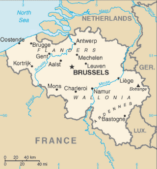
This table shows an overview of the protected heritage sites in the Walloon town Charleroi . This list is part of Belgium's national heritage.
| Object | Year/architect | Town/section | Address | Coordinates | Number? | Image |
|---|---|---|---|---|---|---|
| Church of Saint-Christophe (nl)(fr) | Charleroi | 50°24′43″N4°26′43″E / 50.411906°N 4.445351°E | 52011-CLT-0001-01 Info |  | ||
| Barracks Caporal Trésignies: porch and two towers of the main entrance (nl)(fr) | Charleroi | boulevard Général Michel n°1b | 50°24′40″N4°27′03″E / 50.411058°N 4.450904°E | 52011-CLT-0003-01 Info | 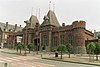 | |
| Church of Saint-Laurent (nl)(fr) | Charleroi | 50°23′41″N4°28′00″E / 50.394709°N 4.466795°E | 52011-CLT-0005-01 Info | 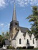 | ||
| Chapel of Saint-Ghislain: choir of the old church (nl)(fr) | Charleroi | rue Vieille église, | 50°24′49″N4°25′35″E / 50.413719°N 4.426338°E | 52011-CLT-0007-01 Info |  | |
| Bois-Lombut (part) (nl)(fr) | Charleroi | 50°27′53″N4°26′43″E / 50.464758°N 4.445162°E | 52011-CLT-0008-02 Info | |||
| Bois-Lombut (part) (nl)(fr) | Charleroi | 50°28′04″N4°26′46″E / 50.467803°N 4.446022°E | 52011-CLT-0010-01 Info | |||
| Church of Saint-Jean: lower tower and three beech trees (nl)(fr) | Charleroi | 50°27′55″N4°25′47″E / 50.465314°N 4.429768°E | 52011-CLT-0011-01 Info |  | ||
| Chapel Notre-Dame de Heigne (nl)(fr) | Charleroi | place du Prieuré | 50°26′45″N4°24′22″E / 50.445940°N 4.406230°E | 52011-CLT-0012-01 Info |  | |
| Church of Saint-Sulpice (nl)(fr) | Charleroi | 50°27′03″N4°25′34″E / 50.450851°N 4.426090°E | 52011-CLT-0013-01 Info |  | ||
| Chapel Notre-Dame des Affligés (nl)(fr) | Charleroi | rue de Gosselies | 50°27′17″N4°25′41″E / 50.454662°N 4.428108°E | 52011-CLT-0014-01 Info |  | |
| St. Martin's Church (nl)(fr) | Charleroi | 50°24′01″N4°26′54″E / 50.400156°N 4.448372°E | 52011-CLT-0016-01 Info |  | ||
| Castle, entrance pavilion and old rectories: roofs and estab (nl)(fr) | Charleroi | Place albert Ier | 50°24′33″N4°22′49″E / 50.409099°N 4.380395°E | 52011-CLT-0017-01 Info | 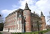 | |
| Chapel du Calvaire (nl)(fr) | Charleroi | place Albert Ier | 50°24′03″N4°28′52″E / 50.400914°N 4.481066°E | 52011-CLT-0018-01 Info |  | |
| Chateau Cartier: porch, castle, base of the walls, except the dovecote (nl)(fr) | Charleroi | Place Albert Ier | 50°24′24″N4°23′38″E / 50.406764°N 4.393772°E | 52011-CLT-0022-01 Info |  | |
| Chateau Cartier and environment (nl)(fr) | Charleroi | 50°24′24″N4°23′37″E / 50.406783°N 4.393651°E | 52011-CLT-0023-01 Info | |||
| Church of Notre-Dame de l'Assomption and its baroque altar (nl)(fr) | Charleroi | 50°26′28″N4°23′33″E / 50.441068°N 4.392413°E | 52011-CLT-0025-01 Info |  | ||
| Terrils du Martinet and protection zone (nl)(fr) | Charleroi | 50°25′49″N4°23′04″E / 50.430269°N 4.384517°E | 52011-CLT-0026-01 Info |  | ||
| Abbey of Saint-Michel: the monastic buildings (facades and roofs), the former church of Saint-Michel and environment (nl)(fr) | Charleroi | rue du Canal. | 50°27′20″N4°24′16″E / 50.455526°N 4.404448°E | 52011-CLT-0028-01 Info |  | |
| Porte of Waterloo or the Belle Alliance and two markers G137 and G138 (nl)(fr) | Charleroi | rue Petite Aise | 50°25′22″N4°27′59″E / 50.422764°N 4.466367°E | 52011-CLT-0029-01 Info |  | |
| Prince Forest (nl)(fr) | Charleroi | 50°22′34″N4°27′42″E / 50.376129°N 4.461687°E | 52011-CLT-0030-01 Info | |||
| Taille de Hublinbu (nl)(fr) | Charleroi | 50°22′24″N4°27′20″E / 50.373315°N 4.455560°E | 52011-CLT-0031-01 Info | |||
| Valley of the river of Fontaine-qui-bout (nl)(fr) | Charleroi | 50°22′09″N4°26′34″E / 50.369088°N 4.442851°E | 52011-CLT-0032-01 Info | 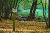 | ||
| Church of Saint-Paul (nl)(fr) | Charleroi | 50°23′26″N4°24′22″E / 50.390435°N 4.406119°E | 52011-CLT-0033-01 Info |  | ||
| Protestant temple (nl)(fr) | Charleroi | boulevard Audent n°s 20-22 | 50°24′34″N4°26′42″E / 50.409558°N 4.444962°E | 52011-CLT-0034-01 Info | 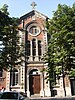 | |
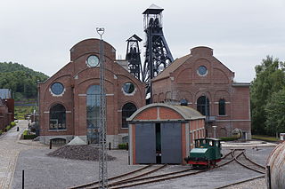
| Coalmine Bois du Cazier: porch entrance, fencing, old set (walls and roofs), concierge, building on the left (facades and roofs), except for the studio and shower block, machine building pit 1 (facades, roofs and metal cladding), two chassis with wheels, not the building that they overlap, and environment including the slag heap Saint-Charles (nl)(fr) | Charleroi | rue du Cazier | 50°22′54″N4°26′39″E / 50.381731°N 4.444083°E | 52011-CLT-0036-01 Info |  | |
| Two towers: facades and roofs (nl)(fr) | Charleroi | rue Cardinal Mercier | 50°23′29″N4°24′26″E / 50.391473°N 4.407247°E | 52011-CLT-0039-01 Info | 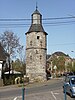 | |
| building (total) (nl)(fr) | Charleroi | rue de Turenne n°2 | 50°24′42″N4°26′37″E / 50.411602°N 4.443701°E | 52011-CLT-0040-01 Info |  | |
| Tumulus Marcinelle and environment (nl)(fr) | Charleroi | rue de la Tombe, n°249 | 50°23′18″N4°25′38″E / 50.388262°N 4.427259°E | 52011-CLT-0042-01 Info | ||
| Gallery, Passage de la Bourse (nl)(fr) | Charleroi | 50°24′27″N4°26′26″E / 50.407507°N 4.440535°E | 52011-CLT-0043-01 Info |  | ||
| House: walls and roofs (nl)(fr) | Charleroi | boulevard Solvay n°7 | 50°24′55″N4°26′45″E / 50.415341°N 4.445775°E | 52011-CLT-0044-01 Info |  | |
| Former post office: walls and roofs, setting conservation (nl)(fr) | Charleroi | place Albert Ier n°23 | 50°24′28″N4°26′35″E / 50.407679°N 4.443099°E | 52011-CLT-0047-01 Info |  | |
| Old theater "Le Varia": gable roof and front (nl)(fr) | Charleroi | rue Lambiotte n°3 | 50°26′18″N4°26′12″E / 50.438315°N 4.436577°E | 52011-CLT-0049-01 Info |  | |
| Completion of the former colliery Appaumée (nl)(fr) | Charleroi | rue l'Appaumée, Nos 99 te 113 | 50°27′06″N4°29′20″E / 50.451580°N 4.488856°E | 52011-CLT-0051-01 Info | ||
| Doree House: walls, ceilings, dining room (including windows and skylights), hall and living room (nl)(fr) | Charleroi | rue Tumelaire n°15 | 50°24′40″N4°26′49″E / 50.411041°N 4.447067°E | 52011-CLT-0053-01 Info |  | |
| House called "de l'Avocat Dermine": facade and roof (nl)(fr) | Charleroi | boulevard Audent n°42 | 50°24′33″N4°26′47″E / 50.409139°N 4.446264°E | 52011-CLT-0054-01 Info | 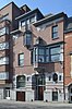 | |
| Facades, roofs and stairs of the building called "The Piano De Heug" (nl)(fr) | Charleroi | Quai de Brabant n°5 | 50°24′22″N4°26′24″E / 50.406225°N 4.440083°E | 52011-CLT-0055-01 Info | 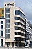 | |
| Art Nouveau house: facade, roofs, stairs, stucco and the staffs of the lobby, woodwork and stained glass windows on the ground floor (nl)(fr) | Charleroi | rue Bernus, n°40. | 50°24′54″N4°26′59″E / 50.415102°N 4.449836°E | 52011-CLT-0056-01 Info | 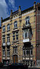 | |
| Facades and roofs, the wall, the railing, the metal gate and the mechanism of the building called "Brasserie des Allies" (nl)(fr) | Charleroi | route de Mons n°38 | 50°24′36″N4°23′32″E / 50.410108°N 4.392122°E | 52011-CLT-0057-01 Info |  | |
| Head of Centre civique Facade and roof and the house of the head of the school (nl)(fr) | Charleroi | rue Massau n°s 2 en 4 | 50°27′55″N4°25′41″E / 50.465152°N 4.428092°E | 52011-CLT-0061-01 Info |  | |
| Facades and roofs of the house on L. Fagnart n ° s 29 to 31 + elements of the interior. Setting conservation (nl)(fr) | Charleroi | L. Fagnart n°s 29-31 | 50°24′58″N4°26′45″E / 50.416070°N 4.445697°E | 52011-CLT-0064-01 Info |  | |
| Facades and roofs of the tower of the ancient castle of Gosselies (nl)(fr) | Charleroi | place des Martyrs | 50°27′55″N4°25′43″E / 50.465310°N 4.428667°E | 52011-CLT-0066-01 Info |  | |
| Building (nl)(fr) | Charleroi | rue de Bomerée 132, Mont-sur-Marchienne | 50°22′24″N4°23′55″E / 50.373391°N 4.398665°E | 52011-CLT-0069-01 Info |  | |
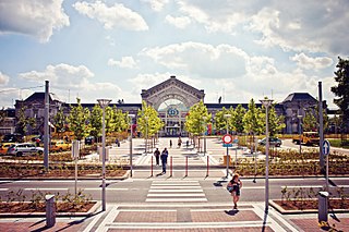
| Hall (total) (nl)(fr) | Charleroi | place Charles II | 50°24′43″N4°26′37″E / 50.411971°N 4.443724°E | 52011-CLT-0070-01 Info |  | |
| Facades and roofs, the circular lobby, indoor pool typical of the thirties of the building called "Amicale Solvay" (nl)(fr) | Charleroi | rue de Châtelet 442, Couillet | 50°23′33″N4°28′40″E / 50.392437°N 4.477726°E | 52011-CLT-0071-01 Info |  | |
| Buildings of the Université du Travail Paul Pastur: different parts (nl)(fr) | Charleroi | 50°25′01″N4°26′46″E / 50.416928°N 4.446221°E | 52011-CLT-0072-01 Info |  | ||
| Organ of the church Saint-Basile (nl)(fr) | Charleroi | Couillet | 50°23′29″N4°28′07″E / 50.391338°N 4.468568°E | 52011-CLT-0075-01 Info |  | |
| Building called "Residence Albert", including elements in accordance with the original design of architect Marcel Leborgne held on the date of this decision (nl)(fr) | Charleroi | avenue Meurée n°s 97-99, Marcinelle | 50°24′11″N4°26′40″E / 50.40292°N 4.44452°E | 52011-CLT-0076-01 Info |  | |
| Facades and roofs of residential buildings (nl)(fr) | Charleroi | rue Bernus n°s 28 tot 56 en 23 tot 55, Charleroi | 50°24′56″N4°27′02″E / 50.41545°N 4.45065°E | 52011-CLT-0077-01 Info |  | |
| Building: walls and roofs (nl)(fr) | Charleroi | rue de Turenne n°4 | 50°24′42″N4°26′37″E / 50.411606°N 4.443577°E | 52011-CLT-0078-01 Info | ||
| Town hall (nl)(fr) | Charleroi | 50°24′43″N4°26′37″E / 50.411971°N 4.443724°E | 52011-PEX-0001-01 Info |  |