This table shows an overview of the protected heritage sites in the Walloon town Couvin . This list is part of Belgium's national heritage.
| Object | Year/architect | Town/section | Address | Coordinates | Number? | Image |
|---|---|---|---|---|---|---|
| Ensemble of the rocks "de la Falaise" (nl)(fr) | Couvin Couvin | 50°03′05″N4°29′45″E / 50.051425°N 4.495874°E | 93014-CLT-0001-01 Info |  | ||
| False door (facades, roofs and passage), the Recollet Brother house (walls, roofs and the main cover except the conservatory and the construction of the 20th century, low pavillon (roofs and facades), high pavillon (facades and roofs), the adjacent walls, and next to the old cemetery of Recollectines, walls around plots 187b and 189 (nl)(fr) | Couvin Couvin | rue de la Montagne | 50°03′04″N4°29′50″E / 50.051150°N 4.497360°E | 93014-CLT-0002-01 Info |  | |
| Farm (nl)(fr) | Cul-des-Sarts Couvin | rue Grande, n°48 | 49°57′24″N4°27′06″E / 49.956710°N 4.451537°E | 93014-CLT-0003-01 Info | ||
| Tower of the church Saint-Georges (nl)(fr) | Gonrieux Couvin | Place des combattants | 50°02′09″N4°25′34″E / 50.035763°N 4.426205°E | 93014-CLT-0006-01 Info | 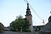 | |
| Central Square (Grand Place) of Mariembourg (nl)(fr) | Mariembourg Couvin | 50°05′42″N4°31′16″E / 50.094926°N 4.521147°E | 93014-CLT-0007-01 Info | 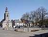 | ||
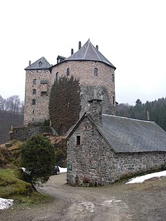
| Tower of the old castle of Petigny (nl)(fr) | Petigny Couvin | rue Chéreulle n°s 10-16 | 50°03′31″N4°32′03″E / 50.058513°N 4.534177°E | 93014-CLT-0008-01 Info | 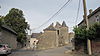 | |
| Chapel Notre-Dame de Messines and ensemble of the chapel, the church of Saint-Marguerite, the oak tree and environment (nl)(fr) | Presgaux Couvin | 50°01′29″N4°25′10″E / 50.024624°N 4.419430°E | 93014-CLT-0009-01 Info |  | ||
| Marsh at "Les Marais" (nl)(fr) | Cul-des-Sarts Couvin | 49°57′31″N4°27′32″E / 49.958730°N 4.458936°E | 93014-CLT-0010-01 Info | |||
| Chapel Notre-Dame de la Bonne Pensee and the ensemble of the chapel and its surroundings (nl)(fr) | Pesche Couvin | rue Maurice Simon | 50°02′45″N4°28′04″E / 50.045902°N 4.467748°E | 93014-CLT-0011-01 Info |  | |
| Two chapels on the rue des calvaires road, and the ensemble of buildings and the area around them (nl)(fr) | Couvin Couvin | rue des Calvaires | 50°03′01″N4°30′06″E / 50.050266°N 4.501801°E | 93014-CLT-0012-01 Info |  | |
| Old house of the bailiff: facades and roofs (nl)(fr) | Pesche Couvin | Place Saint-Hubert, 2 | 50°02′34″N4°27′29″E / 50.042865°N 4.458004°E | 93014-CLT-0013-01 Info |  | |
| Ensemble of the cemetery and the chestnut tree situated at the head of the church of Saint-Quentin (nl)(fr) | Dailly Couvin | rue de l'église | 50°03′28″N4°26′08″E / 50.057730°N 4.435668°E | 93014-CLT-0014-01 Info | 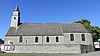 | |
| Chapel Notre-Dame de la Brouffe (nl)(fr) | Mariembourg Couvin | 50°05′32″N4°30′45″E / 50.092130°N 4.512568°E | 93014-CLT-0015-01 Info |  | ||
| Church of Saint-Lambert and the ensemble of the building and its surroundings (nl)(fr) | Aublain Couvin | Place Saint-Lambert | 50°04′01″N4°24′32″E / 50.067003°N 4.408984°E | 93014-CLT-0016-01 Info | ||
| Presbytery and the ensemble of the building and its surroundings (nl)(fr) | Aublain Couvin | rue du Culot n°112 | 50°03′58″N4°24′32″E / 50.065987°N 4.408924°E | 93014-CLT-0017-01 Info | ||
| Farm Walkens: facades and roofs (nl)(fr) | Couvin Couvin | faubourg de la Ville n°7 | 50°03′09″N4°29′52″E / 50.052423°N 4.497852°E | 93014-CLT-0018-01 Info |  | |
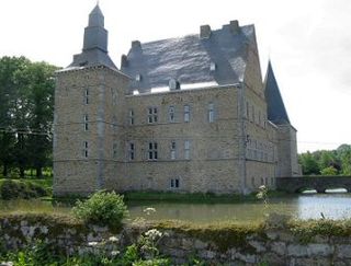
| Castle Boussu-en-Fagne, 16th-century tower (facades and roofs) and part of the main building including the entrance portico, the courtyard, outbuildings built in 1748, the dovecote, the access bridge, moat and surrounding wall and the ensemble of the castle and the park (nl)(fr) | Boussu-en-Fagnes Couvin | rue de la Station n°8 | 50°04′37″N4°28′13″E / 50.077067°N 4.470264°E | 93014-CLT-0019-01 Info | 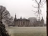 | |
| Bridge Baty, benches, linden trees and surrounding area (nl)(fr) | Petigny Couvin | 50°03′37″N4°31′50″E / 50.060337°N 4.530584°E | 93014-CLT-0020-01 Info |  | ||
| Mansion of Motte: facades and roofs and the ensemble of the building and surrounding area (nl)(fr) | Boussu-en-Fagnes Couvin | rue de la Motte, n°15 | 50°04′44″N4°28′29″E / 50.078797°N 4.474600°E | 93014-CLT-0021-01 Info | 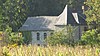 | |
| Drum Castle Court: facades and roofs, except the building adjacent to the west of the house, and the ensemble of the castle and its surroundings (nl)(fr) | Couvin | Hameau de Géronsart, 15 | 50°05′59″N4°29′32″E / 50.099604°N 4.492324°E | 93014-CLT-0022-01 Info |  | |
| Farm Forge: facades and roofs, except the old stables at the rear of the west wing and the stables on the north side sandwiched between two existing buildings, the exterior wall of the northern barn, detached barn to the east, and the ensemble of the farm and the surrounding area (nl)(fr) | Boussu-en-Fagnes Couvin | chemin Fosset n°1 | 50°04′47″N4°27′31″E / 50.079708°N 4.458505°E | 93014-CLT-0023-01 Info | ||
| Chateau Saint-Roch: facades and roofs, excluding annexes, farm Saint-Roch (facades and roofs) with the exception of sheds, stables (facades and roofs), ruins of the driveway to the former furnace, the bridge-dam on the Eau Noire with its cast-iron balustrade, and the ensemble of these buildings and the park of Saint-Roch (nl)(fr) | Couvin Couvin | route de Frasnes n°s 6-16 | 50°03′42″N4°29′47″E / 50.061607°N 4.496362°E | 93014-CLT-0024-01 Info | ||
| Center Brûly-de-Pesche, with meadows and gardens around the main buildings, namely the church of Saint-Meen and the cemetery, the old rectory, former school construction and the lime tree (nl)(fr) | Brûly-de-Pesche Couvin | 50°00′07″N4°27′24″E / 50.001919°N 4.456751°E | 93014-CLT-0026-01 Info |  | ||
| Steam locomotive type EX26 (nl)(fr) | Couvin | 50°05′32″N4°31′49″E / 50.092198°N 4.530214°E | 93014-CLT-0027-01 Info | |||
| Kiosk and a protection zone limited to public space (nl)(fr) | Le Brûly Couvin | place Ch. Claes | 49°58′07″N4°31′40″E / 49.968642°N 4.527738°E | 93014-CLT-0028-01 Info | ||
| Facades, roofs, trim, basements and interior structures of the former town hall of Couvin (nl)(fr) | Couvin Couvin | Grand Place | 50°03′06″N4°29′49″E / 50.051784°N 4.496946°E | 93014-CLT-0029-01 Info | 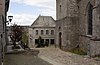 | |
| Facades, roofs and interiors of 'Maison du Concierge "adjacent to the town hall of Couvin (nl)(fr) | Couvin Couvin | Grand Place | 50°03′07″N4°29′49″E / 50.051848°N 4.496952°E | 93014-CLT-0030-01 Info | ||
| The site of the hole Abîme including the ensemble of the rocks of "de la Falaise" (nl)(fr) | Couvin Couvin | 50°03′00″N4°29′54″E / 50.050016°N 4.498316°E | 93014-PEX-0001-01 Info | 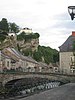 |