This table shows an overview of the protected heritage sites in the Walloon town Eupen . This list is part of Belgium's national heritage.
| Object | Year/architect | Town/section | Address | Coordinates | Number | Image |
|---|---|---|---|---|---|---|
| Church of St. Catherine (nl)(de) | 15th century | Eupen Kettenis | 50°38′46″N6°02′43″E / 50.646050°N 6.045334°E | 31321 Info |  | |
| Villa Schnellewind (nl)(de) | 1737 | Eupen Kettenis | 50°38′13″N6°02′18″E / 50.636956°N 6.038226°E | 31200 Info |  | |
| Fussfall St. Rochus (way of the cross) (nl)(de) | 1724 | Eupen Kettenis | 50°39′22″N6°02′30″E / 50.656077°N 6.041670°E | 31322 Info |  | |
| Castle Libermé (nl)(de) | 16th century | Eupen Kettenis | 50°39′06″N6°02′56″E / 50.651723°N 6.048954°E | 31320 Info |  | |
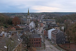
| Favrunbachtal (nl)(de) | protected landscape | Eupen | 50°38′48″N6°02′17″E / 50.646675°N 6.038176°E | 31047 Info | 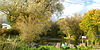 | |
| Tower of Gross Weims (nl)(de) | 14th century | Eupen Kettenis | 50°39′01″N6°02′32″E / 50.650386°N 6.042161°E | 31317 Info | 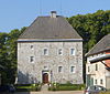 | |
| Philippenhaus (nl)(de) | 1767 | Eupen Kettenis | 50°39′43″N6°03′13″E / 50.661916°N 6.053592°E | 31323 Info | 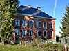 | |
| Old house (nl)(de) | 1790 | Eupen Kettenis | Winkelstrasse 8 | 50°38′45″N6°02′42″E / 50.645781°N 6.045066°E | 31318 Info |  |
| Old house (nl)(de) | Eupen Kettenis | Winkelstrasse 10 | 50°38′45″N6°02′42″E / 50.645745°N 6.044925°E | 31319 Info |  | |
| Belgian-Prussian border markers 158-186 (nl)(de) | 19th century | Eupen | 50°18′31″N6°00′47″E / 50.308639°N 6.013061°E | 31215 Info |  | |
| Church of St. Nicolas (nl)(de) | 1721−1726 Laurenz Mefferdatis | Eupen | 50°37′51″N6°01′57″E / 50.630734°N 6.032577°E | 31133 Info | 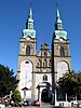 | |
| Rectory (nl)(de) | 1707 | Eupen | 50°37′52″N6°01′58″E / 50.631042°N 6.032886°E | 31132 Info |  | |
| Old churchyard with graves (nl)(de) | 1861−1892 | Eupen | 50°37′50″N6°01′57″E / 50.630488°N 6.032399°E | 31131 Info | 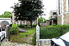 | |
| Church of the Immaculate Conception (nl)(de) | 1773—1776 Joseph Moretti | Eupen | 50°37′57″N6°01′48″E / 50.632499°N 6.030014°E | 31128 Info | 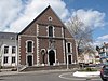 | |
| Town hall (nl)(de) | 1773—1776 Joseph Moretti | Eupen | 50°37′57″N6°01′48″E / 50.632499°N 6.030014°E | 31138 Info | 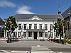 | |
| Chapel of St. Lambert (nl)(de) | 1690 | Eupen | 50°37′57″N6°02′22″E / 50.632511°N 6.039314°E | 31139 Info | 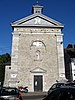 | |
| Chapel of the decapitation of St. John the Baptist (nl)(de) | 1748 Johann Joseph Couven | Eupen | 50°37′59″N6°02′53″E / 50.633087°N 6.048025°E | 31127 Info |  | |
| Old house (nl)(de) | 18th century | Eupen | Bergstrasse 64 | 50°37′41″N6°02′00″E / 50.628078°N 6.033394°E | 31151 Info | 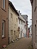 |
| Peace church and 22 gravestones with old wall (nl)(de) | 1851—1855 | Eupen | 50°37′51″N6°02′05″E / 50.630937°N 6.034669°E | 31325 Info |  | |
| Organ of the peace church (nl)(de) | 1907 Eberhard Friedrich Walcker | Eupen | 50°37′51″N6°02′04″E / 50.630968°N 6.034474°E | 31495 Info |  | |
| Ice cellar (nl)(de) | 1869 | Eupen | Borngasse | 50°37′48″N6°02′05″E / 50.629902°N 6.034859°E | 31208 Info | 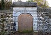 |
| Mountain chapel (Bergkapelle) (nl)(de) | 1712 | Eupen | 50°37′29″N6°02′03″E / 50.624616°N 6.034112°E | 31204 Info |  | |
| Modern gothic St. Joseph church with furnishings (nl)(de) | 1855—1864 Vinzenz Statz | Eupen | 50°37′23″N6°02′23″E / 50.622996°N 6.039588°E | 31406 Info | 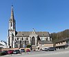 | |
| St. Michaels chapel (nl)(de) | 1700 | Eupen | 50°37′53″N6°00′55″E / 50.631273°N 6.015191°E | 31140 Info | 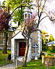 | |
| Maria fountain (nl)(de) | 1774 | Eupen | 50°37′50″N6°01′53″E / 50.630579°N 6.031514°E | 31421 Info |  | |
| Old house (nl)(de) | 1818 | Eupen | Borngasse 1 | 50°37′48″N6°02′03″E / 50.630035°N 6.034098°E | 31207 Info | 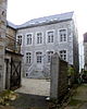 |
| Cross on the Heidberg mountain (nl)(de) | 1819 | Eupen | 50°37′59″N6°02′24″E / 50.632940°N 6.039993°E | 31422 Info | 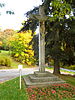 | |
| Old house (nl)(de) | 18th century | Eupen | Edelstrasse 7 | 50°37′27″N6°02′13″E / 50.624251°N 6.037058°E | 31141 Info |  |
| Parts of 17th-century monastery "Rekollektinnen" (nl)(de) | 1700–1727 | Eupen | Heidberg | 50°38′00″N6°02′26″E / 50.633310°N 6.040470°E | 31423 Info |  |
| Old house (nl)(de) | 18th century | Eupen | Gospertstrasse 17 | 50°37′55″N6°02′06″E / 50.631852°N 6.035070°E | 31142 Info |  |
| Old house "Auf'm Rain" (nl)(de) | 1720 | Eupen | Auf'm Rain 2 | 50°37′49″N6°02′29″E / 50.630210°N 6.041292°E | 31116 Info |  |
| Old house (nl)(de) | 1701 | Eupen | Gospertstrasse 22 | 50°37′55″N6°02′04″E / 50.632011°N 6.034546°E | 31143 Info |  |
| Old house (nl)(de) | 18th century | Eupen | Gospertstrasse 42 | 50°37′56″N6°02′06″E / 50.632120°N 6.035133°E | 31144 Info |  |
| Old house (nl)(de) | Eupen | Haasstrasse 1-3 | 50°37′26″N6°02′11″E / 50.623847°N 6.036421°E | 31146 Info |  | |
| Garden of old house (nl)(de) | Eupen | Gospert 40-42 | 50°37′57″N6°02′03″E / 50.632609°N 6.034285°E | 31326 Info | 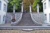 | |
| Old house (nl)(de) | 1724—1728 Laurenz Mefferdatis | Eupen | Kaperberg 2-4 | 50°37′54″N6°02′25″E / 50.631605°N 6.040162°E | 31148 Info | 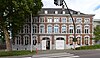 |
| Old house (nl)(de) | 18th century | Eupen | Haasstrasse 24 | 50°37′25″N6°02′17″E / 50.623562°N 6.037998°E | 31152 Info | 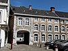 |
| Old house (museum) (nl)(de) | 1697 | Eupen | Gospert 52 | 50°37′56″N6°02′08″E / 50.632231°N 6.035426°E | 31126 Info |  |
| Old house (nl)(de) | 1730 Laurenz Mefferdatis | Eupen | Gospert 56 | 50°37′56″N6°02′08″E / 50.632286°N 6.035684°E | 31221 Info |  |
| Old house (nl)(de) | 18th century | Eupen | Gospert 68 | 50°37′57″N6°02′09″E / 50.632411°N 6.035950°E | 31145 Info |  |
| Parliament building of the German-Speaking community of Belgium (nl)(de) | 1812 | Eupen | Kaperberg 8 | 50°37′53″N6°02′26″E / 50.631308°N 6.040584°E | 31160 Info | 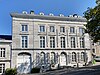 |
| Old house (nl)(de) | 18th century | Eupen | Haasstrasse 26 | 50°37′25″N6°02′17″E / 50.623515°N 6.038133°E | 31153 Info |  |
| Old house (nl)(de) | 1645 | Eupen | Haasstrasse 28 | 50°37′24″N6°02′18″E / 50.623437°N 6.038210°E | 31154 Info | 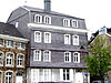 |
| Old house (nl)(de) | 1745 | Eupen | Kaperberg 31-33 | 50°37′51″N6°02′28″E / 50.630696°N 6.041020°E | 31339 Info | 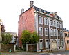 |
| Old house (nl)(de) | 1748 | Eupen | Haasstrasse 40 | 50°37′24″N6°02′19″E / 50.623228°N 6.038606°E | 31336 Info | 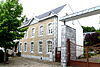 |
| Old house (nl)(de) | 1710 | Eupen | Kirchstrasse 1 | 50°37′49″N6°01′55″E / 50.630389°N 6.031927°E | 31340 Info |  |
| Old house (nl)(de) | 1747 Laurenz Mefferdatis | Eupen | Haasstrasse 42 | 50°37′23″N6°02′20″E / 50.623068°N 6.038797°E | 31337 Info |  |
| Old house (nl)(de) | 1830 | Eupen | Kirchstrasse 16 | 50°37′49″N6°01′58″E / 50.630220°N 6.032907°E | 31341 Info | 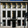 |
| Old house (nl)(de) | 1723 | Eupen | Heggenstrasse 8 | 50°38′00″N6°02′01″E / 50.633321°N 6.033664°E | 31155 Info |  |
| Old house Kirchstrasse 17-23 (nl)(de) | 1713 | Eupen | Kirchstrasse 17 | 50°37′48″N6°01′57″E / 50.630134°N 6.032366°E | 31342 Info |  |
| Old house (nl)(de) | 18th century | Eupen | Heggenstrasse 10 | 50°38′00″N6°02′01″E / 50.633367°N 6.033736°E | 31156 Info |  |
| Old house (nl)(de) | 19th century | Eupen | Klosterstrasse 20 | 50°37′53″N6°01′52″E / 50.631515°N 6.031070°E | 31161 Info |  |
| Old house (nl)(de) | 18th century | Eupen | Heggenstrasse 14 | 50°38′00″N6°02′02″E / 50.633433°N 6.033869°E | 31157 Info |  |
| Old house (nl)(de) | 1757 | Eupen | Klötzerbahn 27 | 50°37′53″N6°02′05″E / 50.631346°N 6.034603°E | 31164 Info |  |
| Old house (nl)(de) | 1800 | Eupen | Paveestrasse 22 | 50°37′51″N6°01′48″E / 50.630735°N 6.030110°E | 31193 Info |  |
| Old house (nl)(de) | 1733 | Eupen | Hochstrasse 185 | 50°38′44″N6°01′29″E / 50.645576°N 6.024725°E | 31158 Info |  |
| Lane with trees (nl)(de) | protected landscape | Eupen | Hochstrasse | 50°38′42″N6°01′27″E / 50.644965°N 6.024182°E | 31429 Info | 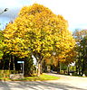 |
| Old house (nl)(de) | 18th century | Eupen | Paveestrasse 29 | 50°37′50″N6°01′49″E / 50.630424°N 6.030304°E | 31194 Info |  |
| Parliament building of the German-Speaking community of Belgium (nl)(de) | 1760—1763 Johann Joseph Couven | Eupen | Klötzerbahn 32 | 50°37′53″N6°02′02″E / 50.631268°N 6.033969°E | 31343 Info | 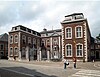 |
| Old house (nl)(de) | 1748 Laurenz Mefferdatis | Eupen | Rotenberg 33 | 50°37′26″N6°01′49″E / 50.623857°N 6.030205°E | 31149 Info |  |
| Steinrother Wäldchen (nl)(de) | protected landscape | Eupen | 50°37′20″N6°00′25″E / 50.622185°N 6.006877°E | 31045 Info | 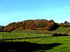 | |
| Cloister of the Franciscans (nl)(de) | 1752 Johann Joseph Couven | Eupen | Marktplatz 1 | 50°37′49″N6°01′52″E / 50.630182°N 6.030975°E | 31172 Info |  |
| Old house (nl)(de) | 1744 Johann Joseph Couven | Eupen | Werthplatz 1-3 | 50°37′57″N6°02′17″E / 50.632483°N 6.038066°E | 31357 Info | 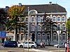 |
| Old house (nl)(de) | 1750 | Eupen | Marktplatz 8 | 50°37′51″N6°01′52″E / 50.630696°N 6.031172°E | 31173 Info |  |
| Old house (nl)(de) | 17th century | Eupen | Werthplatz 2 | 50°37′59″N6°02′18″E / 50.632931°N 6.038465°E | 31358 Info | 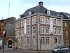 |
| Nispert house (nl)(de) | 1747 Johann Joseph Couven | Eupen | Couvenplatz 1 | 50°37′59″N6°02′52″E / 50.633186°N 6.047884°E | 31117 Info | 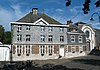 |
| Old houses (nl)(de) | 1747 | Eupen | Werthplatz 5-7-9 | 50°37′56″N6°02′18″E / 50.632354°N 6.038273°E | 31195 Info |  |
| Park of Nispert house (nl)(de) | Eupen | Couvenplatz 1 | 50°38′01″N6°02′53″E / 50.633559°N 6.048011°E | 31344 Info | 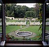 | |
| Werthplatz house (nl)(de) | Eupen | Werthplatz 12 | 50°37′59″N6°02′20″E / 50.632927°N 6.038991°E | 31359 Info | 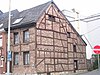 | |
| Werthplatz house (nl)(de) | 18th century | Eupen | Werthplatz 48 | 50°37′55″N6°02′23″E / 50.631986°N 6.039646°E | 31360 Info |  |
| Lange Kuhdrift (nl)(de) | protected landscape | Eupen | 50°36′45″N6°03′13″E / 50.612394°N 6.053659°E | 31046 Info |  | |
| Old house (nl)(de) | 18th century | Eupen | Nispert 56 | 50°37′55″N6°03′03″E / 50.631814°N 6.050926°E | 31175 Info |  |
| Castle Stockem (nl)(de) | 1502 | Eupen | 50°37′49″N6°00′59″E / 50.630238°N 6.016284°E | 31324 Info | 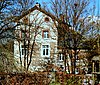 | |
| Oe house (nl)(de) | 1745 Johann Conrad Schlaun | Eupen | Oestrasse 48 | 50°37′00″N6°01′20″E / 50.616645°N 6.022335°E | 31176 Info |  |
| Old house (nl)(de) | 18th century | Eupen | Olengraben 29 | 50°37′26″N6°02′02″E / 50.623992°N 6.033847°E | 31178 Info |  |
| Old house (nl)(de) | 19th century | Eupen | Paveestrasse 12 | 50°37′52″N6°01′47″E / 50.630982°N 6.029652°E | 31191 Info |  |
| Old houses (nl)(de) | 1815 | Eupen | Paveestrasse 13-15 | 50°37′50″N6°01′47″E / 50.630607°N 6.029806°E | 31180 Info | 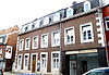 |
| Old house (nl)(de) | Eupen | Paveestrasse 14 | 50°37′51″N6°01′47″E / 50.630924°N 6.029719°E | 31192 Info |  | |
| Old house (nl)(de) | 1850 | Eupen | Paveestrasse 10 | 50°37′52″N6°01′46″E / 50.631090°N 6.029542°E | 31190 Info |  |
| Timber-framed house (nl)(de) | 1610 | Eupen | Hufengasse 11 | 50°37′48″N6°01′51″E / 50.630115°N 6.030711°E | 31338 Info |  |
| Old house (nl)(de) | 1707 | Eupen | Hookstrasse 40 | 50°38′02″N6°02′17″E / 50.633792°N 6.037930°E | 31159 Info | 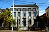 |
| Old house (nl)(de) | 18th century | Eupen | Nispert 51 | 50°37′55″N6°03′00″E / 50.632008°N 6.050033°E | 31174 Info |  |
| War memorial (nl)(de) | 1912 Rudolf Henn | Eupen | Werthplatz | 50°37′56″N6°02′21″E / 50.63224317°N 6.03913329°E | 852 Info | 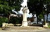 |
| Garden shed of the house Place Werth 36-38 (the facade, the roof, the staircase, the cellar and the historical elements of the interior) (nl)(de) | 18th century | Eupen | Werthplatz 36–38 | 50°37′57″N6°02′25″E / 50.63240139°N 6.04024104°E | 31522 Info | 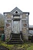 |
| Waldenburg House (house and outbuildings) (nl)(de) | 17th century | Eupen Kettenis | Hochstraße 269 | 50°39′33″N6°02′59″E / 50.65915682°N 6.04958564°E | 32239 Info | 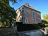 |
| House Bergstraße 62 (facade and roof) (nl)(de) | 1720 | Eupen | Bergstraße 62 | 50°37′41″N6°02′00″E / 50.62813346°N 6.03341912°E | 31206 Info |  |
| Former cinema Capitol (front) (nl)(de) | 1933 Bemelmans | Eupen | Neustraße 79 | 50°37′34″N6°01′52″E / 50.62610823°N 6.03114335°E | 1006 Info |  |
| Transformer house Merolser Straße (de) | 1928 | Eupen Kettenis | Merolser Straße | 50°39′40″N6°03′47″E / 50.66115°N 6.06300°E | 40770 Info |  |
| Grange Looten | 18th century | Eupen | Bergstraße 111 | 50°37′36″N6°02′01″E / 50.62654°N 6.03360°E | 82110 Info |  |
| Schulstraße 18 | 18th century | Eupen | Schulstraße 18 | 50°37′52″N6°02′12″E / 50.63100°N 6.03675°E | 106854 Info |  |