List of protected heritage sites in Perwez

Last updated

This table shows an overview of the protected heritage sites in the Walloon town Perwijs, or Perwez . This list is part of Belgium's national heritage.

Object
Year/architect
Town/section
Address
Coordinates
Number?
Image
Tower of the church of Saint-Jean-Baptiste (nl)(fr)
PerwijsWastinnes 50°40′12″N4°48′10″E / 50.669956°N 4.802733°E / 50.669956; 4.802733

25084-CLT-0001-01  Info

Organs of the church of Saint-Martin-les-Beguines Thorembais, including the balustrade and an ensemble with the buffet of the instrument (nl)(fr)
Perwijs 50°39′31″N4°49′06″E / 50.658687°N 4.818344°E / 50.658687; 4.818344

25084-CLT-0002-01  Info

Chapel of Saint-Roch and the ensemble of the chapel and its surroundings (nl)(fr)
Perwijsrue Saint-Roch, Perwez 50°37′09″N4°49′05″E / 50.619253°N 4.818000°E / 50.619253; 4.818000

25084-CLT-0003-01  Info

Kapel Saint-Roch en het ensemble van de kapel en diens omgeving Chapel of Saint-Roch Perwez.jpg
Kapel Saint-Roch en het ensemble van de kapel en diens omgeving
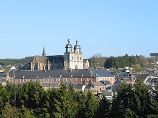
Church of Saint-Trond and the churchyard wall, and the ensemble of the Church and surroundings (nl)(fr)
PerwijsPerwez 50°38′08″N4°47′06″E / 50.635553°N 4.785035°E / 50.635553; 4.785035

25084-CLT-0004-01  Info

Ensemble of the buildings and the cobbled courtyard of the farm of Mont in Perwez, and the ensemble of the farm, the lane, the entrance and surrounding area (nl)(fr)
Perwijs 50°39′37″N4°48′52″E / 50.660220°N 4.814509°E / 50.660220; 4.814509

25084-CLT-0005-01  Info

Ensemble van de gebouwen en de geplaveide binnenplaats van de boerderij van Mont te Perwez, alsook het ensemble van de boerderij, de dreef, de toegangsweg en de omliggende terreinen 2014-09-13 14.35.13 Ferme du Mont a Thorembais-les-Beguines.jpg
Ensemble van de gebouwen en de geplaveide binnenplaats van de boerderij van Mont te Perwez, alsook het ensemble van de boerderij, de dreef, de toegangsweg en de omliggende terreinen
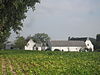
The facades and roofs of small Cense (nl)(fr)
PerwijsPerwez 50°39′22″N4°49′10″E / 50.656086°N 4.819397°E / 50.656086; 4.819397

25084-CLT-0006-01  Info

The facades and roofs of the portico, the main building and the street wing, and the totality of the driveway of the farm (nl)(fr)
Perwijsrue Trémouroux n°94, Perwez 50°38′15″N4°45′45″E / 50.637454°N 4.762453°E / 50.637454; 4.762453

25084-CLT-0007-01  Info

De gevels en daken van de portiek, het hoofdgebouw en de straatvleugel, en de totaliteit van de doorgang van de boerderij 2014-09-13 15.16.46 Ferme rue Tremouroux 94 a Perwez.jpg
De gevels en daken van de portiek, het hoofdgebouw en de straatvleugel, en de totaliteit van de doorgang van de boerderij
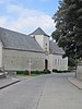
Farm of Mellemont, the totality of the two barns, the porch in the southeast, wells and stables (A), the four western bays (B) and the surrounding wall, the stones today the second courtyard, the façades and roofs of other buildings except the four modern buildings, and the ensemble of the farm, the stream Thorembais, the rows of poplars and the agricultural plain. (nl)
Perwijs 50°39′08″N4°48′24″E / 50.652343°N 4.806591°E / 50.652343; 4.806591

25084-CLT-0008-01  Info

Boerderij van Mellemont, de totaliteit van de twee schuren, het portiek in het zuidoosten, waterputten en stallen (A), de vier westelijke traveeen (B) en de omliggende muur, de stenen vand e binnenplaats, de gevels en daken van de andere gebouwen uitgezonderd de vier moderne bijgebouwen, en het ensemble van de boerderij, de stroom Thorembais, de rijen populieren en de agrarische vlakte. 2014-09-13 14.23.40 Ferme de Mellemont a Thorembais-les-Beguines.jpg
Boerderij van Mellemont, de totaliteit van de twee schuren, het portiek in het zuidoosten, waterputten en stallen (A), de vier westelijke traveeën (B) en de omliggende muur, de stenen vand e binnenplaats, de gevels en daken van de andere gebouwen uitgezonderd de vier moderne bijgebouwen, en het ensemble van de boerderij, de stroom Thorembais, de rijen populieren en de agrarische vlakte.

See also

Related Research Articles

Walloon Brabant Province of Belgium

Walloon Brabant is a province of Wallonia and Belgium. It borders on the province of Flemish Brabant and the provinces of Liège, Namur and Hainaut (Wallonia). Its capital and largest city is Wavre.

Perwez Municipality in French Community, Belgium

Perwez is a Walloon municipality located in the Belgian province of Walloon Brabant. On 1 January 2006 the municipality had 7,487 inhabitants. The total area is 50.81 km², giving a population density of 147 inhabitants per km².

Yvoir Municipality in French Community, Belgium

Yvoir is a Walloon municipality located in the Belgian province of Namur. On 1 January 2006 the municipality had 8,450 inhabitants. The total area is 56.84 km², making it a population density of 149 inhabitants per km².

La Bruyère, Belgium Municipality in Namur Province, Belgium

La Bruyère is a Walloon municipality in Namur Province, Belgium. The municipality was created during the post-1974 fusion of the Belgian municipalities, adding together the ancienne communes of Émines, Rhisnes, Villers-lez-Heest, Warisoulx, Bovesse, Meux and Saint-Denis-Bovesse. Rhisnes is the administrative seat of the municipality.

Gembloux Municipality in Namur Province, Belgium

Gembloux is a Walloon city and surrounding municipality in Namur Province, Belgium.

Ohey Municipality in Namur Province, Belgium

Ohey is a Walloon municipality in Namur Province, Belgium.

Sombreffe Municipality in Namur Province, Belgium

Sombreffe is a Walloon municipality in Namur Province, Belgium. On 1 January 2014 the municipality had 8,226 inhabitants. The total area is 35.78 km², giving a population density of 230 inhabitants per km².

Couvin Municipality in French Community, Belgium

Couvin is a Walloon municipality located in the Belgian province of Namur.

Villers-le-Bouillet Municipality in French Community, Belgium

Villers-le-Bouillet is a Walloon municipality of Belgium in Liège Province. On January 1, 2006, Villers-le-Bouillet had a total population of 6,051. The total area is 32.71 km2 which gives a population density of 185 inhabitants per km2.

Ans Municipality in French Community, Belgium

Ans is a small Belgian municipality located in the Walloon province of Liège. On January 1, 2006, Ans had a total population of 27,322. The total area is 23.35 km² which gives a population density of 1,170 inhabitants per km². Its postal code is 4430.

Flémalle Municipality in French Community, Belgium

Flémalle is a Walloon municipality located in the Belgian province of Liège. On January 1, 2006, Flémalle had a total population of 25,140. The total area is 36.68 km² which gives a population density of 685 inhabitants per km².

Saint-Nicolas, Liège Municipality in French Community, Belgium

Saint-Nicolas is a municipality of Belgium. It lies in the country's Walloon Region and Liège Province. It is effectively a part of the greater Liège conurbation stretching west from Liège city centre towards Liège Airport. As of January 1, 2006 Saint-Nicolas had a total population of 22,666. The total area is 6.84 km2 which gives a population density of 3,313 inhabitants per km2. It has the highest population density of any Belgian municipality outside the Brussels-Capital Region.

Attert Municipality in French Community, Belgium

Attert is a Walloon municipality of Belgium located in the province of Luxembourg. On 1 January 2007 the municipality, which covers 70.94 km², had 4,802 inhabitants, giving a population density of 67.7 inhabitants per km².

Saint-Hubert, Belgium Municipality in French Community, Belgium

Saint-Hubert is a Walloon municipality of Belgium located in the province of Luxembourg. On 1 January 2007 the municipality, which covers 111.16 km², had 5,737 inhabitants, giving a population density of 51.6 inhabitants per square kilometre.

Heritage registers in Belgium Cultural property of Belgium

Heritage registers in Belgium include immovable heritage such as World Heritage Sites, and National heritage sites, but also intangible cultural heritage. The agency responsible for keeping and updating inventories of immovable heritage is dependent on the region, as is the name for the object, which is called Beschermd erfgoed, Biens classés or Kulturdenkmal depending on the language of the municipality of the location.

References