List of protected heritage sites in Thuin

Last updated

This table shows an overview of the protected heritage sites in the Walloon town Thuin . This list is part of Belgium's national heritage.

Beschermd erfgoed type of heritage protection in Flanders

Beschermd erfgoed is the official term to describe Flemish National Heritage Sites listed by law to protect and spread awareness of Belgian cultural heritage, specifically in Flanders. The term is also used nationwide to refer to national heritage sites. Because Belgium is officially a tri-lingual country, the other nationwide terms used in the rest of the country are the French term Bien classé and the German term Kulturdenkmal.

Thuin Municipality in French Community, Belgium

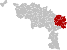
Thuin or [twɛ̃]) is a Walloon municipality located in the Belgian province of Hainaut. The Thuin municipality includes the old communes of Leers-et-Fosteau, Biesme-sous-Thuin, Ragnies, Biercée, Gozée, Donstiennes, and Thuillies.

Object
Year/architect
Town/section
Address
Coordinates
Number?
Image
Thuin Belfry (nl)(fr)
Thuinrue Albert Ier 50°20′23″N4°17′12″E / 50.339645°N 4.286605°E / 50.339645; 4.286605

56078-CLT-0001-01  Info

Belfort van Thuin Belfort van Thuin.jpg
Belfort van Thuin
House "espagnole": facade (nl)(fr)
ThuinGrand-Rue n°21 50°20′20″N4°17′18″E / 50.339016°N 4.288350°E / 50.339016; 4.288350

56078-CLT-0004-01  Info

Huis "espagnole": gevel Thuin - maison espagnole - 2018-09-09 - 02.jpg
Huis "espagnole": gevel
Cloister Chapel of the Grey Nuns (nl)(fr)
ThuinThuin 50°20′20″N4°17′29″E / 50.338835°N 4.291392°E / 50.338835; 4.291392

56078-CLT-0005-01  Info

"Jardins suspendus"- hanging garders of Thuin (nl)(fr)
ThuinThuin 50°20′18″N4°17′25″E / 50.338295°N 4.290162°E / 50.338295; 4.290162

56078-CLT-0006-01  Info

"Jardins suspendus" van Thuin Thuin JPG001.jpg
"Jardins suspendus" van Thuin
Organs of the chapel of the Soeurs de Notre-Dame (nl)(fr)
Thuin 50°20′20″N4°17′29″E / 50.338911°N 4.291429°E / 50.338911; 4.291429

56078-CLT-0007-01  Info

Organs of the church of Notre-Dame des Carmes (nl)(fr)
Thuin 50°20′19″N4°17′16″E / 50.338739°N 4.287856°E / 50.338739; 4.287856

56078-CLT-0008-01  Info

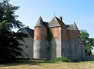
Castle Leers-et-Fosteau and the facades and roofs of the outbuildings and the ensemble of the building and surrounding areas (nl)(fr)
Thuin 50°18′18″N4°15′07″E / 50.304867°N 4.252007°E / 50.304867; 4.252007

56078-CLT-0010-01  Info

kasteel van Leers-et-Fosteau en de gevels en daken van de bijgebouwen en het ensemble van het gebouw en de omliggende terreinen Fosteau JPG01.jpg
kasteel van Leers-et-Fosteau en de gevels en daken van de bijgebouwen en het ensemble van het gebouw en de omliggende terreinen
Woodland Church of Gozée (nl)(fr)
Thuin 50°21′08″N4°22′14″E / 50.352106°N 4.370620°E / 50.352106; 4.370620

56078-CLT-0012-01  Info

Various woods, meadows and a pond near the abbey farm Aulne (nl)(fr)
Thuin 50°21′44″N4°19′56″E / 50.362354°N 4.332106°E / 50.362354; 4.332106

56078-CLT-0013-01  Info

Verschillende bossen, weilanden en een vijver in de buurt van de abdij-hoeve van Aulne Gozee Ab1aJPG.jpg
Verschillende bossen, weilanden en een vijver in de buurt van de abdij-hoeve van Aulne
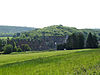
Land near the abbey farm Aulne (nl)(fr)
Thuin 50°21′38″N4°20′11″E / 50.360482°N 4.336369°E / 50.360482; 4.336369

56078-CLT-0014-01  Info

St. Martin's Church (nl)(fr)
ThuinRagnies 50°18′30″N4°17′03″E / 50.308314°N 4.284191°E / 50.308314; 4.284191

56078-CLT-0015-01  Info

Kerk Saint-Martin Ragnies JPG000.jpg
Kerk Saint-Martin
Chapel of Ossogne and environment (nl)(fr)
Thuin 50°17′28″N4°20′34″E / 50.291162°N 4.342670°E / 50.291162; 4.342670

56078-CLT-0016-01  Info

Total parsonage Ragnies (nl)(fr)
Thuin 50°18′31″N4°17′01″E / 50.308679°N 4.283698°E / 50.308679; 4.283698

56078-CLT-0017-01  Info

Galleries at the foot of the belfry (nl)(fr)
Thuinplace du Chapitre 50°20′23″N4°17′12″E / 50.339728°N 4.286694°E / 50.339728; 4.286694

56078-CLT-0018-01  Info

Galerijen aan de voet van het belfort Belfry of Thuin (DSCF7769-DSCF7771).jpg
Galerijen aan de voet van het belfort
Church of Notre-Dame d'el Vaux, retaining wall, sidewalk along the southern facade of the church, cobbled alleyways, stairway under the arch of the choir and the ensemble formed by the building, sidewalks, alleys and square du Moustier (old cemetery) (nl)(fr)
Thuin 50°20′28″N4°16′54″E / 50.341148°N 4.281764°E / 50.341148; 4.281764

56078-CLT-0019-01  Info

Ensemble formed by the buildings on Grand-Rue n ° s 36 and 38, and the park "Refuge d'Aulne" (now park of the town hall) (nl)(fr)
ThuinGrand-Rue n°s 36 et 38 50°20′22″N4°17′18″E / 50.339509°N 4.288421°E / 50.339509; 4.288421

56078-CLT-0020-01  Info

Mill Biesmelle (nl)(fr)
Thuinrue des Compères 50°17′51″N4°19′54″E / 50.297606°N 4.331766°E / 50.297606; 4.331766

56078-CLT-0021-01  Info

House facades and roofs, except under a glass roof of the beginning of the century) and the house adjacent to the courtyard on the west (nl)(fr)
Thuinplace Albert Ier n°13 50°20′22″N4°17′11″E / 50.339407°N 4.286435°E / 50.339407; 4.286435

56078-CLT-0022-01  Info

Menhir called "Le Zeupire", near Route de Beaumont. Setting conservation. (nl)(fr)
ThuinGozée 50°19′45″N4°20′54″E / 50.329192°N 4.348334°E / 50.329192; 4.348334

56078-CLT-0023-01  Info

Menhir genaamd "Le Zeupire", nabij route de Beaumont. Instelling beschermingszone. Gozee Do1bJPG.jpg
Menhir genaamd "Le Zeupire", nabij route de Beaumont. Instelling beschermingszone.
The two remaining arches of the bridge over the Moines river called the Sambre downstream of the old abbey of Aulne, and on the right bank of this stream, rue de Leernes 13 (with the exception of the house built on the platform that can be accessed via the bridge and the masonry around the arches) (nl)(fr)
Thuinrue de Leernes 13 50°22′00″N4°20′11″E / 50.366595°N 4.336379°E / 50.366595; 4.336379

56078-CLT-0024-01  Info

Forest of Grand Bon Dieu (nl)(fr)
Thuin 50°19′54″N4°17′11″E / 50.331714°N 4.286486°E / 50.331714; 4.286486

56078-CLT-0025-01  Info

Certain parts of the Aulne Abbey, with the abbey farm and the ensemble of the abbey and surrounding areas (nl)(fr)
Thuin 50°21′57″N4°19′53″E / 50.365738°N 4.331394°E / 50.365738; 4.331394

56078-CLT-0026-01  Info

Bepaalde delen van de abdij van Aulne, met de abdij-hoeve en het ensemble van de abdij en de omliggende terreinen 0 Gozee Aulne 050525 (2).JPG
Bepaalde delen van de abdij van Aulne, met de abdij-hoeve en het ensemble van de abdij en de omliggende terreinen
More images
Farmhouse Grande Couture and its environment (nl)(fr)
Thuin 50°17′45″N4°19′31″E / 50.295825°N 4.325184°E / 50.295825; 4.325184

56078-CLT-0028-01  Info

Zone around the forest "Bois du Prince" (nl)(fr)
Thuin 50°22′00″N4°20′26″E / 50.366646°N 4.340587°E / 50.366646; 4.340587

56078-CLT-0029-01  Info

Thuin Belfry (nl)(fr)
Thuin 50°20′23″N4°17′12″E / 50.339645°N 4.286605°E / 50.339645; 4.286605

56078-PEX-0001-01  Info

Belfort van Thuin Belfort van Thuin.jpg
Belfort van Thuin
"Jardins suspendus" of Thuin (nl)(fr)
ThuinThuin 50°20′18″N4°17′25″E / 50.338295°N 4.290162°E / 50.338295; 4.290162

56078-PEX-0002-01  Info

"Jardins suspendus" van Thuin Thuin JPG02.jpg
"Jardins suspendus" van Thuin
Site of the Aulne Abbey and surrounding areas including the farm (nl)(fr)
Thuin 50°21′51″N4°19′56″E / 50.364186°N 4.332111°E / 50.364186; 4.332111

56078-PEX-0003-01  Info

Site van de abdij van Aulne en de omliggende terreinen met inbegrip van de hoeve 0 Gozee Aulne 050525 (2).JPG
Site van de abdij van Aulne en de omliggende terreinen met inbegrip van de hoeve

See also

Related Research Articles

World Heritage Site place listed by the UNESCO as of special cultural or natural significance

A World Heritage Site is a landmark or area which is chosen by the United Nations Educational, Scientific and Cultural Organisation (UNESCO) as having cultural, historical, scientific or other form of significance, and is legally protected by international treaties. The sites are judged important to the collective interests of humanity.

Hainaut Province Province of Belgium

Hainaut, historically also known as Heynowes in English, is a province of Wallonia and Belgium.

Wanze Municipality in French Community, Belgium

Wanze is a Walloon municipality of Belgium located in the province of Liège. It consists of the former municipalities of Wanze, Antheit, Bas-Oha, Huccorgne, Moha and Vinalmont.

Ferrières, Belgium Municipality in French Community, Belgium

Ferrières is a Walloon municipality located in the Belgian province of Liège. On January 1, 2006, Ferrières had a total population of 4,449. The total area is 56.90 km² with a population density of 78 inhabitants per km².

ASVi museum Heritage railway in Belgium

The ASVi is a tramway museum in Thuin in Belgium, which specialises in the history of the Belgian narrow gauge Vicinal system. The museum includes an operating museum tram line which runs from Thuin to Lobbes.

Arrondissement of Charleroi Arrondissement of Belgium in Wallonia

The Arrondissement of Charleroi is one of the seven administrative arrondissements in the Province of Hainaut, Belgium. It is both an administrative and a judicial arrondissement. However, the Judicial Arrondissement of Charleroi also comprises the municipalities of the Arrondissement of Thuin.

Arrondissement of Thuin Arrondissement in Wallonia, Belgium

The Arrondissement of Thuin is one of the seven administrative arrondissements in the Province of Hainaut, Belgium.

Raoul Charles de Thuin (1890–1975) was a prolific stamp forger and dealer who was originally a citizen of Belgium but who operated from Mérida, Yucatán, Mexico, of which country he eventually became a naturalised citizen. De Thuin's work was considered so dangerous to philately that his tools and stock were purchased by the American Philatelic Society in 1966 in order to curtail his activities.

Fosteau Castle château

Fosteau Castle is a castle in Leers-et-Fosteau in the municipality of Thuin, province of Hainaut, in Belgium.

Heritage registers in Belgium cultural property of Belgium

Heritage registers in Belgium include immovable heritage such as World Heritage Sites, and National heritage sites, but also intangible cultural heritage. The agency responsible for keeping and updating inventories of immovable heritage is dependent on the region, as is the name for the object, which is called Beschermd erfgoed, Biens classés or Kulturdenkmal depending on the language of the municipality of the location.

This page is an overview of the list of protected heritage sites in Liège (province), alphabetically ordered by town name. This list is part of the national heritage of Belgium.

This page is an overview of the list of protected heritage sites in Hainaut (province), alphabetically ordered by town name. This list is part of the protected heritage sites of Belgium.

This page is an overview of the beschermd erfgoed in Luxembourg (Belgium), alphabetically ordered by town name. This list is part of the protected heritage sites of Belgium.

Thuin (Walloon Parliament constituency)

Thuin is a parliamentary constituency in Belgium used to elect members of the Walloon Parliament since 1995. It corresponds to the Arrondissement of Thuin.

Charleroi-Thuin (Walloon Parliament constituency)

Charleroi-Thuin is a parliamentary constituency in Belgium used to elect members of the Walloon Parliament from 2019. It corresponds to the arrondissments of Charleroi and Thuin. It was created from the former constituencies of Charleroi and Thuin and was first contested for the 2019 Belgian regional elections.

Charleroi-Thuin was a constituency used to elect members of the Belgian Chamber of Representatives between 1995 and 2003.

Thuin was a constituency used to elect members of the Belgian Chamber of Representatives between 1831 and 1900.

References