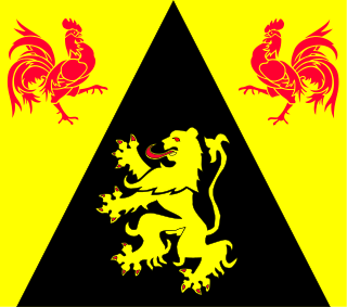
Walloon Brabant is a province of Wallonia and Belgium. It borders on the province of Flemish Brabant and the provinces of Liège, Namur and Hainaut (Wallonia). Its capital and largest city is Wavre.

Walhain is a Walloon municipality of Belgium located in the province of Walloon Brabant. It consists of the former municipalities of Nil-Saint-Vincent-Saint-Martin, Tourinnes-Saint-Lambert and Walhain-Saint-Paul.

Yvoir is a Walloon municipality located in the Belgian province of Namur. On 1 January 2006 the municipality had 8,450 inhabitants. The total area is 56.84 km², making it a population density of 149 inhabitants per km².

La Bruyère is a Walloon municipality in Namur Province, Belgium. The municipality was created during the post-1974 fusion of the Belgian municipalities, adding together the ancienne communes of Émines, Rhisnes, Villers-lez-Heest, Warisoulx, Bovesse, Meux and Saint-Denis-Bovesse. Rhisnes is the administrative seat of the municipality.
Gembloux is a Walloon city and surrounding municipality in Namur Province, Belgium.

Sombreffe is a Walloon municipality in Namur Province, Belgium. On 1 January 2014 the municipality had 8,226 inhabitants. The total area is 35.78 km², giving a population density of 230 inhabitants per km².

Couvin is a Walloon municipality located in the Belgian province of Namur.

Villers-le-Bouillet is a Walloon municipality of Belgium in Liège Province. On January 1, 2006, Villers-le-Bouillet had a total population of 6,051. The total area is 32.71 km2 which gives a population density of 185 inhabitants per km2.

Ans is a small Belgian municipality located in the Walloon province of Liège. On January 1, 2006, Ans had a total population of 27,322. The total area is 23.35 km² which gives a population density of 1,170 inhabitants per km². Its postal code is 4430.
Flémalle is a Walloon municipality located in the Belgian province of Liège. On January 1, 2006, Flémalle had a total population of 25,140. The total area is 36.68 km² which gives a population density of 685 inhabitants per km².

Saint-Nicolas is a municipality of Belgium. It lies in the country's Walloon Region and Liège Province. It is effectively a part of the greater Liège conurbation stretching west from Liège city centre towards Liège Airport. As of January 1, 2006 Saint-Nicolas had a total population of 22,666. The total area is 6.84 km2 which gives a population density of 3,313 inhabitants per km2. It has the highest population density of any Belgian municipality outside the Brussels-Capital Region.

André M. J. Gh. Flahaut is a Belgian politician, then in the province of Brabant and now in the province of Walloon Brabant. Flahaut studied political sciences and public administration at the Université Libre de Bruxelles.

Nil-Saint-Vincent-Saint-Martin is a former municipality in the province of Walloon Brabant, Belgium. In 1976 it became part of the municipality of Walhain.

Royal Wallonia Walhain Chaumont-Gistoux is a Belgian association football club located in the municipality of Walhain, Walloon Brabant. They have played in the third division since 1997–98. However, in 2006–07, the club could not avoid relegation to the 4th level of Belgian football, i.e. the Promotion.

Heritage registers in Belgium include immovable heritage such as World Heritage Sites, and National heritage sites, but also intangible cultural heritage. The agency responsible for keeping and updating inventories of immovable heritage is dependent on the region, as is the name for the object, which is called Beschermd erfgoed, Biens classés or Kulturdenkmal depending on the language of the municipality of the location.
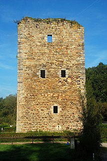
Alvaux Tower, also known as Tour d'Alvaux or Alvau or also called Saracen tower, is a plain residential tower of the late 12th century located in Nil-Saint-Vincent-Saint-Martin, a village in the Belgian town of Walhain, the province of Walloon Brabant.


