Related Research Articles

Suffolk is a ceremonial county of England in East Anglia. It borders Norfolk to the north, Cambridgeshire to the west and Essex to the south; the North Sea lies to the east. The county town is Ipswich; other important towns include Lowestoft, Bury St Edmunds, Newmarket, and Felixstowe which has one of the largest container ports in Europe.
The Suffolk Coast Path is a long-distance footpath along the Suffolk Heritage Coast in England. It is 50 miles (80 km) long.

The Suffolk Coast and Heaths AONB is an Area of Outstanding Natural Beauty in Suffolk and Essex, England.

RSPB Minsmere is a nature reserve owned and managed by the Royal Society for the Protection of Birds (RSPB) at Minsmere, Suffolk. The 1,000-hectare (2,500-acre) site has been managed by the RSPB since 1947 and covers areas of reed bed, lowland heath, acid grassland, wet grassland, woodland and shingle vegetation. It lies within the Suffolk Coast and Heaths Area of Outstanding Natural Beauty and the Suffolk Heritage Coast area. It is conserved as a Site of Special Scientific Interest, Special Area of Conservation, Special Protection Area and Ramsar site.
This article describes the history of Suffolk, the English county.
Minsmere is a place in the English county of Suffolk. It is located on the North Sea coast around 3.5 miles (5.6 km) north of Leiston and 1.5 miles (2.4 km) south-east of Westleton within the Suffolk Coast and Heaths AONB. It is the site of the Minsmere RSPB reserve and the original site of Leiston Abbey.

Covehithe is a village and civil parish in the East Suffolk district of the English county of Suffolk. It lies on the North Sea coast around 4 miles (6.4 km) north of Southwold and 7 miles (11 km) south of Lowestoft. Neighbouring settlements include Benacre, South Cove and Frostenden.
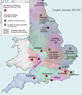
Dommoc, a place not certainly identified but probably within the modern county of Suffolk, was the original seat of the Anglo-Saxon bishops of the Kingdom of East Anglia. It was established by Sigeberht of East Anglia for Saint Felix in c. 629–31. It remained the bishopric of all East Anglia until c. 673, when Theodore of Tarsus, Archbishop of Canterbury, divided the see and created a second bishopric at either North Elmham, Norfolk, or South Elmham, Suffolk. The see of Dommoc continued to exist until the time of the Viking Wars of the 860s, after which it lapsed.

Ipswich Hospital is a large district general hospital in Heath Road, Ipswich, Suffolk, England. It is now managed by East Suffolk and North Essex NHS Foundation Trust which was formed on 1 July 2018 by the merging of Ipswich Hospital NHS Trust with Colchester Hospital University NHS Foundation Trust.
The Sandlings Walk is a long-distance path in Suffolk, England. It runs through the Suffolk Sandling that used to stretch from the outskirts of Ipswich to Southwold which is an area of lowland heath, Britain's rarest wildlife habitat, and the Suffolk Coast and Heaths Area of Outstanding Natural Beauty.
The Bishop of Dunwich is an episcopal title which was first used by an Anglo-Saxons bishop between the 7th and 9th centuries and is currently used by the suffragan bishop of the Diocese of St Edmundsbury and Ipswich. The title takes its name after Dunwich in the English county of Suffolk, which has now largely been lost to the sea.

Dunwich is a village and civil parish in Suffolk, England. It is in the Suffolk Coast and Heaths AONB around 92 miles (148 km) north-east of London, 9 miles (14 km) south of Southwold and 7 miles (11 km) north of Leiston, on the North Sea coast.

Dunwich Heath is an area of coastal lowland heath just south of the village of Dunwich, in the Suffolk Coast and Heaths AONB, England. It is adjacent to the RSPB reserve at Minsmere. It lies within the area of the Minsmere-Walberswick Heaths and Marshes Site of Special Scientific Interest, Special Area of Conservation and Special Protection Area.

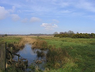
Dingle Marshes is a 93-hectare (230-acre) wildlife reserve on the North Sea coast of the English county of Suffolk. The reserve is located between Dunwich and Walberswick, approximately 4 miles (6.4 km) south-west of Southwold. The marshes make up part of the Suffolk Coast National Nature Reserve along with reserves at Walberswick and Hen Reedbeds. They are owned jointly by the RSPB and Suffolk Wildlife Trust and are managed by these two organisations and Natural England. The site is in the Dunwich Heaths and Marshes Nature Conservation Review site, Grade I, the Minsmere-Walberswick Ramsar internationally important wetland site, the Minsmere to Walberswick Heaths and Marshes Special Area of Conservation, and the Minsmere-Walberswick Special Protection Area under the European Union Directive on the Conservation of Wild Birds.

Dunwich Forest is an area of forest and lowland heath around 1 mile (1.6 km) north-east of the village of Dunwich in the English county of Suffolk. The forest covers an area of around 9 square kilometres and was originally planted by the Forestry Commission. The forest is within the Suffolk Coast and Heaths Area of Outstanding Natural Beauty and is in the area known as the Suffolk Sandlings. South of the reserve is the National Trust property of Dunwich Heath, one of the largest remaining areas of lowland heath on the Suffolk coast, and the RSPB reserve at Minsmere. To the north and east of the forest are Dingle Marshes, part of the Suffolk Coast National Nature Reserve.

Bixley Heath is a 5.1 hectare biological Site of Special Scientific Interest on the eastern outskirts of Ipswich in Suffolk. It is also a Local Nature Reserve owned and managed by Ipswich Borough Council.

Minsmere–Walberswick Heaths and Marshes are a Special Area of Conservation and Site of Special Scientific Interest in the English county of Suffolk. The site is located on the North Sea coast between Southwold and Sizewell, extending over an area of coastline around 7 miles (11 km) in length. The site is also designated as a Special Protection Area, part of the Minsmere–Walberswick European Marine Site and contains areas designated as Ramsar sites and Natura 2000 sites. It lies within the Suffolk Coast and Heaths Area of Outstanding Natural Beauty and is made up of a "complex mosaic" of marshes, reed beds, shingle banks and lowland heath habitats.

Potton Hall Fields, Westleton is a 16.7 hectare biological Site of Special Scientific Interest ( west of Dunwich in Suffolk. It is in the Suffolk Coast and Heaths Area of Outstanding Natural Beauty.
Ipswich Heaths is a 39.4 hectare biological Site of Special Scientific Interest in Ipswich in Suffolk.
References
- ↑ Dixon, Roger, ed. (2012). A Celebration of Suffolk Geoloogy. Ipswich: GeoSuffolk.: 2