
Imathia is one of the regional units of Greece. It is part of the region of Central Macedonia, within the geographic region of Macedonia. The capital of Imathia is the city of Veroia.

The 2004 Summer Olympics Torch Relay took the Olympic Flame across every habitable continent, returning to Athens, Greece. Every city which had hosted, will host, or coincidentally elected to host the Summer Olympics until the 2028 Summer Olympics was visited or revisited by the torch, as well as several other cities chosen for their international importance. The main reason why the torch relay went around the world was to highlight the fact that the Olympic Games were started in Greece and in modern times have been held around the world and then took place in Greece in 2004.

The provinces of Greece were sub-divisions of some the country's prefectures. From 1887, the provinces were abolished as actual administrative units, but were retained for some state services, especially financial and educational services, as well as for electoral purposes. Before the Second World War, there were 139 provinces, and after the war, with the addition of the Dodecanese Islands, their number grew to 147. According to the Article 7 of the Code of Prefectural Self-Government, the provinces constituted a "particular administrative district" within the wider "administrative district" of the prefectures. The provinces were finally abolished after the 2006 local elections, in line with Law 2539/1997, as part of the wide-ranging administrative reform known as the "Kapodistrias Project", and replaced by enlarged municipalities (demoi).

Agia Varvara is a suburban town in the western part of the Athens agglomeration in Attica, Greece and a municipality in the West Athens regional unit.
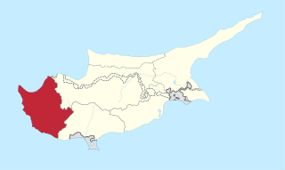
Paphos District is one of the six districts of Cyprus and it is situated in the western part of Cyprus. Its main town and capital is Paphos. The entire district is controlled by the internationally recognised government of Cyprus. There are four municipalities in Paphos District: Paphos, Yeroskipou, Peyia, and Polis Chrysochous.

Porto Rafti, officially named Limin Markopoulou, is a seaside resort town located in East Attica, Greece.

Tritaia is a former municipality in Achaea, West Greece, Greece. Since the 2011 local government reform it is part of the municipality Erymanthos, of which it is a municipal unit. The municipal unit has an area of 244.798 km2. The seat of the municipality was in Stavrodromi. Tritaia was named after the ancient Achaean city Tritaea, which was located near the present village Agia Marina. Tritaia is situated in mountainous southern Achaea, on the border with Elis. It nearly surrounds the municipal unit Kalentzi. Mount Erymanthos is located in the eastern part of Tritaia. The Greek National Road 33 runs through Tritaia.

Episkopi is a former municipality in the Heraklion regional unit, Crete, Greece. Since the 2011 local government reform, it has been part of the municipality Hersonissos, of which it is a municipal unit. The municipal unit has an area of 45.500 km2 (17.568 sq mi). The population of Episkopi as of 2021 is 2,291.

Thiseio or Thissio is a traditional neighbourhood in the old city of Athens, Greece, northwest of the Acropolis, and surrounded by the archaeological sites of the Agora, Keramikos and Pnyx. The name refers to the Temple of Hephaestus, which was mistakenly known as Thiseion, in reference to Theseus, the mythical king of Athens.

Ayia Marina is a village located in the Paphos District of Cyprus, in the Tylliria region.
Agia Marina is a village in Cyprus, situated 24 km west of Nicosia. It takes its name from Marina the Monk, the Christian saint of Byzantine Syria. De facto, Agia Marina is under the control of Northern Cyprus.

Agia Marina is an underground metro station in Athens, Greece. The station has park-and-ride facilities. A part of the Piraeus extension, construction works on the station began in 2007, before the rest of the extension. It was expected to become operational by 2010 but was delayed several times due to the Siemens Greek bribery scandal. The station opened to the public on 14 December 2013 and served as the line's western terminus until 2020.

Limassol District or Lemesos is one of the six districts of Cyprus. As of 2021, it had a population of 262,238, 75,7% of which was urban The district's capital city is Limassol. Part of the British Overseas Territory of Akrotiri and Dhekelia forms an enclave on the Akrotiri Peninsula, under the sovereignty of the United Kingdom.

The Longos Mansion, also known as the Red House due to its red brick exterior, is a three-storey house in Agias Sofias Square in the center of Thessaloniki. It was designed in 1926 by architect Leonardo Gennari for the family of Grigorios Longos – a wealthy textile industrialist from Naousa, in the Neobyzantine style. He later gave it to his brother, Ioannis, which is why it is known as "Ioannis Longos mansion". In 1983, it was listed by the Greek Ministry of Culture for preservation.

Roumlouki or Kampania (Καμπανία), is the traditional name of the northeastern part of Imathia located in Macedonia, Greece, specifically the plain of the lower Aliakmon River.