
Eastern Macedonia and Thrace is one of the thirteen administrative regions of Greece. It consists of the northeastern parts of the country, comprising the eastern part of the region of Macedonia along with the region of Western Thrace, and the islands of Thasos and Samothrace.

Xylokastro is a seaside town and a former municipality in Corinthia in the Peloponnese, Greece. Since the 2011 local government reform it is part of the municipality Xylokastro-Evrostina, of which it is a unit or component. The municipal unit has an area of 310.252 km2.

Dymi is a former municipality in Achaea, West Greece, Greece. Since the 2011 local government reform it is part of the municipality West Achaea, of which it is a municipal unit. The municipal unit has an area of 71.553 km2. Its seat of administration was the town of Kato Achaia. It is located 20 km southwest of Patras.
Limnochori is a village and a community in the municipal unit of Movri in Achaea, Greece. The community consists of the villages Limnochori, Kalamaki, Kato Limnochori and Paralia Kalamakiou. It is located in the plains near the Gulf of Patras. It is 4 km north of Sageika, 4 km southeast of Lakkopetra, 6 km west of Kato Achaia and 4 km east of Araxos Airport.
Makrysi is a village and a community in the municipality of Megalopoli, Arcadia, Greece. It is situated on a hillside on the left bank of the river Elissonas, at 496 m elevation. It is 3 km northwest of Mallota and 3 km northeast of Megalopoli town centre. The community consists of the villages Makrysi and Kato Makrysi. Kato Makrysi is situated at 450 m elevation. Zacharias Barbitsiotis, an anti-Ottoman insurgent defeated the Turks in Sialesi in the 1780s.

Kalavryta is a town and a municipality in the mountainous east-central part of the regional unit of Achaea, Greece. The town is located on the right bank of the river Vouraikos, 24 kilometres south of Aigio, 40 km southeast of Patras and 62 km northwest of Tripoli. Notable mountains in the municipality are Mount Erymanthos in the west and Aroania or Chelmos in the southeast. Kalavryta is the southern terminus of the Diakopto-Kalavryta rack railway, built by Italian engineers between 1885 and 1895.
Agia Paraskevi is a suburb of Athens, Greece. It may also refer to:

Drama is one of the regional units of Greece. It is part of the Region of East Macedonia and Thrace. Its capital is the town of Drama. The regional unit is the northernmost within the geographical region of Macedonia and the westernmost in the administrative region of East Macedonia and Thrace. The northern border with Bulgaria is formed by the Rhodope Mountains.

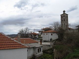
Kato Nevrokopi is a municipality and town within that municipality in the northwest section of the Drama regional unit, Greece. Before the 2011 local government reform, it was the largest municipality in all of Greece, covering an area of 873.552 km2. The 2021 census reported a population of 5,323 inhabitants. The region is known for the very low temperatures during the winter and for its famous agricultural products such as potatoes and beans. The area has several features to attract tourists: the ski center of Falakro, the traditional settlement in the village of Granitis, the historical bunker of Lise, the artificial lakes of Lefkogeia and Potamoí, the spectacular routes in the forests, the old churches. The forest paths offer excellent views to hikers. The largest towns are Kato Nevrokopi, Volakas (783), Perithorio (569), Lefkogeia (321), Ochyro (314), Kato Vrontou (287) and Vathytopos (255). On the territory of the municipality are located several abandoned villages, including Monastiri and Mavrochori.

Kato Achaia is a town and a community in Achaea, West Greece, Greece. Since the 2011 local government reform it is part of the municipality West Achaea, of which it is the seat of administration. The community Kato Achaia consists of the town Kato Achaia and the villages Alykes, Manetaiikia, Paralia Kato Achaias and Piso Sykea. Nearby are the ruins of the ancient city of Dyme.

Paranesti is a municipality in the Rhodope Mountains of northeastern Drama regional unit, Greece. It consists of two municipal units: Paranesti and Nikoforos. The largest villages of the municipal unit Paranesti are Paranésti, Mesochório (105), Káto Thólos (123), Χágnanto (43), and Prasináda (32).

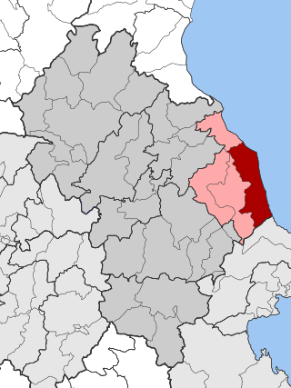
Sidironero is a village and a former community in the Drama regional unit, East Macedonia and Thrace, Greece. Since the 2011 local government reform it is part of the municipality Drama, of which it is a municipal unit. It lies in the Rhodope Mountains region along the Bulgarian border in the northern part of the Drama regional unit between Kato Nevrokopi and Paranesti. Its land area is 351.273 km2 (135.627 sq mi).
Melivoia is a town and a former municipality in the Larissa regional unit, Thessaly, Greece. Since the 2011 local government reform it is part of the municipality Agia, of which it is a municipal unit. The municipal unit has an area of 197.633 km2. The seat of the municipality was in Kato Sotiritsa. Melivoia is located east of Larissa, the capital of the regional unit and Thessaly, and a few kilometers north of Agia. The municipal unit stretches along the Aegean Sea coast, at the foot of Mount Ossa. It was named after the ancient city Meliboea. The municipal unit borders on Magnesia to the southeast.
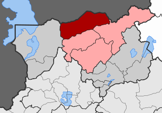
Ano Vrontou is a remote mountain village and a former community in the northern Serres regional unit, Greece. Since the 2011 local government reform it is part of the municipality Serres, of which it is a municipal unit. Each year on August astrophotography hobbyists gather there due to the clear view of the night sky, a result of the villages high elevation. The municipal unit has an area of 47.306 km2. Ano Vrontou is situated in the northeastern part of the Vrontous mountains, at about 1060 m elevation. It borders on the Drama regional unit to the north and east. Ano Vrontou is 6 km northwest of Kato Vrontou, 12 km east of Achladochori, 13 km northeast of Oreini, 16 km southwest of Kato Nevrokopi and 26 km northeast of Serres.
Kato Kleines is a village and a former municipality in Florina regional unit, West Macedonia, Greece. Since the 2011 local government reform it is part of the municipality Florina, of which it is a municipal unit. The municipal unit has an area of 188.564 km2. It is 7 km north of the city of Florina. The population was 2,132 in 2021.
Giannaioi is a community of the municipal unit of Falaisia in Arcadia, Peloponnese, Greece. It consists of the two mountain villages Ano Giannaioi and Kato Giannaioi. Ano Giannaioi is 1 km southeast of Kato Giannaioi. Both villages are situated on a mountain slope, in the northern foothills of the Taygetus mountains, between 600 and 700 m elevation. Kato Giannaioi is 1 km south of Kamara, 5 km north of Dyrrachio, 11 km southeast of Leontari and 19 km south of Megalopoli.
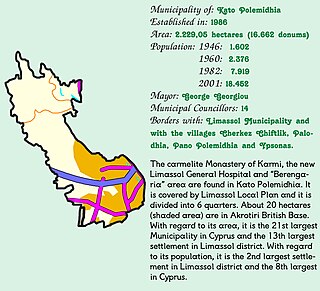
Kato Polemidia is a municipality of Cyprus, located in the district of Limassol. It has a population of 22,369 according to the 2011 census.

Greek National Road 57 is a national highway of Greece. It connects Drama with the Bulgarian border near Exochi, via Prosotsani and Kato Nevrokopi. At the border it is connected with the Bulgarian national road 19 to Gotse Delchev.
Kapodistrias reform is the common name of law 2539 of Greece, which reorganised the country's administrative divisions. The law, named after 19th-century Greek statesman, passed the Hellenic Parliament in 1997, and was implemented in 1998. The administrative system was changed again at the 2010 Kallikratis reform.