
The Nelson River is a river of north-central North America, in the Canadian province of Manitoba. The river drains Lake Winnipeg and runs 644 kilometres (400 mi) before it ends in Hudson Bay. Its full length is 2,575 kilometres (1,600 mi), it has mean discharge of 2,370 cubic metres per second (84,000 cu ft/s), and has a drainage basin of 1,072,300 square kilometres (414,000 sq mi), of which 180,000 square kilometres (69,000 sq mi) is in the United States.
Churchill River may refer to:
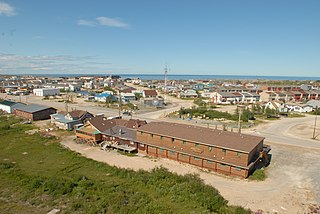
Churchill is an Arctic town in northern Manitoba, Canada, on the west shore of Hudson Bay, roughly 140 km (87 mi) from the Manitoba–Nunavut border. It is most famous for the many polar bears that move toward the shore from inland in the autumn, leading to the nickname "Polar Bear Capital of the World," and to the benefit of its burgeoning tourism industry.

The Chipewyan are a Dene Indigenous Canadian people of the Athabaskan language family, whose ancestors are identified with the Taltheilei Shale archaeological tradition. They are part of the Northern Athabascan group of peoples, and hail from what is now Western Canada.

Arviat is a predominantly Inuit hamlet located on the western shore of Hudson Bay in the Kivalliq Region of Nunavut, Canada. Arviat is derived from the Inuktitut word arviq meaning "Bowhead whale". Earlier in history, its name was Tikirajualaaq, and Ittaliurvik,.

The Churchill River is a major river in Alberta, Saskatchewan and Manitoba, Canada. From the head of the Churchill Lake it is 1,609 kilometres (1,000 mi) long. It was named after John Churchill, 1st Duke of Marlborough and governor of the Hudson's Bay Company from 1685 to 1691.

The Nisichawayasihk Cree Nation is a Cree First Nations community centered in Nelson House, Manitoba, Canada. Its main reserve is Nelson House 170.

Northern Manitoba is a geographic and cultural region of the Canadian province of Manitoba. Originally encompassing a small square around the Red River Colony, the province was extended north to the 60th parallel in 1912. The region's specific boundaries vary, as "northern" communities are considered to share certain social and geographic characteristics, regardless of latitude.

Churchill Airport is located 3 nautical miles east-southeast of Churchill, Manitoba, Canada. The airport serves the town of Churchill and the surrounding region. Although it is a small domestic airport, it handles a relatively high number of passengers throughout the year as Churchill is a major destination for ecotourism and scientific research. Churchill Airport also serves as a transfer airport for passengers and cargo travelling between Winnipeg and remote communities in the Kivalliq Region of Nunavut.
Churchill Water Aerodrome is located 5 nautical miles southeast of Churchill, Manitoba, Canada.
Nejanilini Lake Airport is located adjacent to Nejanilini Lake, Manitoba, Canada and serves The Lodge at Little Duck.
North Seal River Airport is located on the shore of Egenolf Lake adjacent to North Seal River, Manitoba, Canada.
Sandy Bay Airport is located 1.3 nautical miles north-east of Sandy Bay, Saskatchewan, Canada. The airport and community are on the shores of Wasawakasik Lake, which is along the course of the Churchill River.
Tadoule Lake is an isolated northern community in Manitoba reachable by plane, snowmobile, dog team sleds, and in winter by winter road. In 1973, the Sayisi Dene moved here to return to their Barren-ground Caribou hunting life.
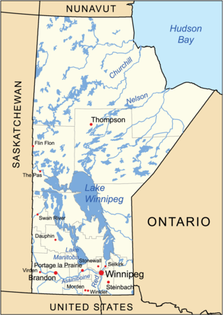
The geography of Manitoba addresses the easternmost of the three prairie Canadian provinces, located in the longitudinal centre of Canada. Manitoba borders on Saskatchewan to the west, Ontario to the east, Nunavut to the north, and the American states of North Dakota and Minnesota to the south. Although the border with Saskatchewan appears straight on large-scale maps, it actually has many right-angle corners that give the appearance of a slanted line. In elevation, Manitoba ranges from sea level on Hudson Bay to 2727 ft (831 m) on top of Baldy Mountain. The northern sixty percent of the province is on the Canadian Shield. The northernmost regions of Manitoba lie permafrost, and a section of tundra bordering Hudson Bay.
The Sayisi Dene are Chipewyan peoples, a Dene group, living in northern Manitoba. They are members of the Sayisi Dene First Nation, located at Tadoule Lake, and are notable for living a nomadic caribou-hunting and gathering existence. They are the most eastern of all the Dene peoples.
The Seal River is a river in the Northern Region of Manitoba, Canada. It travels 260 kilometres (160 mi) from Shethanei Lake to the Hudson Bay. The river was nominated for the Canadian Heritage Rivers System in 1987 and was officially listed in 1992. In January 2024, the Governments of Canada and Manitoba and Members of the Sayisi Dene First Nation, O-Pipon-Na-Piwin Cree Nation, Northlands Denesuline First Nation and Barren Lands First Nation reached an agreement to designate the watershed as an Indigenous and community conserved area.
The Little Churchill River is a river in the Hudson Bay drainage basin in Northern Manitoba, Canada. It flows from Waskaiowaka Lake to the Churchill River.

