
Delta County is a county in the Upper Peninsula in the U.S. state of Michigan. As of the 2010 United States Census, the population was 37,069. The county seat is Escanaba. The county was surveyed in 1843 and organized in 1861. Its name originates from the Greek letter "delta", which refers to the triangular shape of the original county which included segments of Menominee, Dickinson, Iron, and Marquette counties.

Benzie County is a county in the U.S. state of Michigan. As of the 2010 census, the population was 17,525. The county seat is Beulah. The county was initially set off in 1863 and organized in 1869.

Alger County is a county in the Upper Peninsula of the U.S. state of Michigan. As of the 2010 census, the population was 9,601. Its county seat is Munising. The Pictured Rocks National Lakeshore is located within the county.

Au Train Township is a civil township of Alger County in the U.S. state of Michigan. As of the 2010 census, the township population was 1,138.

Munising Township is a civil township of Alger County in the U.S. state of Michigan. As of the 2010 census, the township population was 2,983.

Emmett Charter Township is a charter township of Calhoun County in the U.S. state of Michigan. It is part of the Battle Creek Metropolitan Statistical Area. The population was 11,770 at the 2010 census.

Forest Township is a civil township of Cheboygan County in the U.S. state of Michigan. The population was 1,045 at the 2010 census.
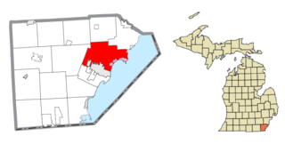
Frenchtown Charter Township is a charter township within Monroe County in the U.S. state of Michigan. The population was 20,428 at the 2010 census. The township is bordered on the south by the city of Monroe. Sterling State Park and the Enrico Fermi Nuclear Generating Station are located within Frenchtown, and the township was the site of the Battle of Frenchtown during the War of 1812.

Hiawatha National Forest is a 894,836-acre (362,127 ha) National Forest in the Upper Peninsula of the state of Michigan in the United States. Commercial logging is conducted in some areas. The United States Forest Service administers this National Forest; it is physically divided into two subunits, commonly called the Eastside 46°14′N84°50′W and Westside 46°08′N86°40′W. In descending order of land area it lies in parts of Chippewa, Delta, Mackinac, Alger, Schoolcraft, and Marquette counties. Chippewa and Mackinac counties are in the Eastside, whereas the rest are in the Westside. The smaller Eastside contains about 44% of the forest's area, whereas the larger Westside has about 56%. Forest headquarters are located in Escanaba, Michigan. Eastside ranger district offices are located in Sault Ste. Marie and St. Ignace, while Westside offices are in Manistique, Munising, and Rapid River.
Gull Island is the name of a dozen small islands in the U.S. state of Michigan.

Otter Lake is the name of several lakes and one village in the U.S. state of Michigan.
Carp River is a 40.2-mile-long (64.7 km) river in Chippewa and Mackinac counties in the U.S. state of Michigan. 21.7 miles (34.9 km) of the river were added to the National Wild and Scenic Rivers System in 1992.
The Whitefish River is an 11.9-mile-long (19.2 km) river on the Upper Peninsula of the U.S. state of Michigan. The mouth of the river is in Delta County at 45°54′34″N86°58′01″W on the Little Bay De Noc of Lake Michigan. The main branch of the river is formed by the confluence of the east and west branches at 46°03′25″N86°52′17″W.

The Betsie River is a 54.0-mile-long (86.9 km) stream in the northwest part of the U.S. state of Michigan. The name is derived from the French la rivière aux Bec-scies, meaning river of sawbill ducks (bec-scie). Other alternate names include Aug-sig-o-sebe, Aux Buscies, Betsey's River, Black Robe, Gay-she-say-ing, Riviere du Pere Marquette, Sawbill Ducks, and Shelldrake Ducks. The river is mostly within Benzie County, although the river rises in southwest Grand Traverse County and flows briefly through northern Manistee County, Michigan.
The Iron River is a 17.1-mile-long (27.5 km) river in Iron County, Michigan, in the United States. It flows from northwest to southeast through the city of Iron River to the Brule River. It is part of the Menominee River watershed, flowing to Lake Michigan.
The Lincoln River is a 7.8-mile-long (12.6 km) river in Mason County, Michigan, in the United States. It is formed by the confluence of its North and South branches 5 miles (8 km) northeast of Ludington and flows westward to Lake Michigan. Part of Lincoln river runs through a small private community called epworth

Sturgeon River may refer to any of the following streams in the U.S. state of Michigan:
Sturgeon River is a 63.6-mile-long (102.4 km) river in the U.S. state of Michigan, flowing mostly southward through Alger County and Delta County counties on the Upper Peninsula.

Indian River is a 59.1-mile-long (95.1 km) tributary of the Manistique River on the Upper Peninsula of Michigan in the United States. It rises out of Hovey Lake at 46°17′36″N86°42′20″W on Hiawatha National Forest land in Alger County and flows south and east through a lake district and on through Schoolcraft County. The river flows into the 8,659 acre (35 km²) Indian Lake at 46°17′36″N86°42′20″W and flows out at 45°59′30″N86°17′15″W. It then flows east and south about 2.5 miles where it merges with the Manistique River, which then flows through Manistique and into Lake Michigan at 45°56′56″N86°14′45″W.
The Rock River is a 17.5-mile-long (28.2 km) river in Alger County on the Upper Peninsula of Michigan in the United States. It flows through the Rock River Canyon Wilderness of Hiawatha National Forest, then turns north and flows to Lake Superior at the village of Rock River.


