
Snowdonia, or Eryri, is a mountainous region and national park in North Wales. It contains all 15 mountains in Wales over 3000 feet high, including the country's highest, Snowdon, which is 1,085 metres (3,560 ft) tall. These peaks are all part of the Snowdon, Glyderau, and Carneddau ranges in the north of the region. The shorter Moelwynion and Moel Hebog ranges lie immediately to the south.

Powys is a county and preserved county in Wales. It borders Gwynedd, Denbighshire, and Wrexham to the north; the English ceremonial counties of Shropshire and Herefordshire to the east; Monmouthshire, Blaenau Gwent, Merthyr Tydfil, Caerphilly, Rhondda Cynon Taf, and Neath Port Talbot to the south; and Carmarthenshire and Ceredigion to the west. The largest settlement is Newtown, and the administrative centre is Llandrindod Wells.

Snowdon, or Yr Wyddfa, is a mountain in Snowdonia in North Wales. It has an elevation of 1,085 metres (3,560 ft) above sea level, which makes it both the highest mountain in Wales and the highest in the British Isles south of the Scottish Highlands. Snowdon is designated a national nature reserve for its rare flora and fauna, and is located within Snowdonia National Park.

Afon Rheidol is a river in Ceredigion, Wales, 19 miles (31 km) in length. The source is Plynlimon. Receiving an average annual rainfall of 40 inches (1.02 m), Plynlimon is also the source of both the Wye and the Severn.

Pen-y-Gwryd is a pass at the head of Nantygwryd and Nant Cynnyd rivers close to the foot of Snowdon in Gwynedd, Wales. The area is located at the junction of the A4086 from Capel Curig to Llanberis and Caernarfon and the A498 from Beddgelert and Nant Gwynant about a mile from the head of the Llanberis Pass. It is close to the boundary with Conwy county borough in northern Snowdonia. The famous mountaineering hostelry, Pen-y-Gwryd Hotel, is located in the pass. It is also a mountain rescue post with links to the other rescue posts at Ogwen Cottage and Plas y Brenin.

The River Rhondda is a river in South Wales with two major tributaries, Rhondda Fawr and Rhondda Fach.

The Llanberis Pass in Snowdonia carries the main road (A4086) from the south-east to Llanberis, over Pen-y-Pass, between the mountain ranges of the Glyderau and the Snowdon massif. At the bottom of the pass is the small village of Nant Peris.

Llynnau Mymbyr are two lakes located in Dyffryn Mymbyr, a valley running from the village of Capel Curig to the Pen-y-Gwryd hotel in Snowdonia, north-west Wales. The A4086 runs along their northern banks.

Llyn Cowlyd is the deepest lake in northern Wales. It lies in the Snowdonia National Park at the upper end of Cwm Cowlyd on the south-eastern edge of the Carneddau range of mountains, at a height of 330 metres (1,083 ft) above sea level. The lake is long and narrow, measuring nearly 3 kilometres (2 mi) long and about 500 m wide, and covers an area of 1.1 square kilometres. It has a mean depth of 33 metres (108 ft) and at its deepest has given soundings of 70 metres (230 ft), this being some 14 m (46 ft) greater than its natural depth, the water surface having been raised twice by the building of dams.

Llyn Ogwen is a ribbon lake in north-west Wales. It lies alongside the A5 road between two mountain ranges of Snowdonia, the Carneddau and the Glyderau. Somewhat unusually, the county boundary at this point is drawn so that the lake itself lies in the county of Gwynedd, but all the surrounding land lies in Conwy County Borough.

Nant Gwynant is a valley in northern Wales. The A498 road descends 600 feet (180 m) into the valley in about two miles (3 km) from Pen-y-Gwryd; it follows the Nant Cynnyd, the Afon Glaslyn and alongside Llyn Gwynant, then beside the Nant Gwynant river to Llyn Dinas and passing below Dinas Emrys to Beddgelert. The road continues through the Aberglaslyn Pass to Porthmadog.

Cwm Idwal is a cirque in the Glyderau range of mountains in northern Snowdonia, the national park in the mountainous region of North Wales. Its main interest is to hill walkers and rock climbers, but it is also of interest to geologists and naturalists, given its combination of altitude, aspect (north-facing) and terrain. In a 2005 poll conducted by Radio Times, Cwm Idwal was ranked the 7th greatest natural wonder in Britain.
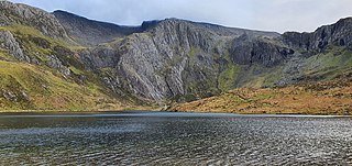
Llyn Idwal is a small lake that lies within Cwm Idwal in the Glyderau mountains of Snowdonia.

Dyffryn Mymbyr is a valley in Snowdonia, in north-west Wales, approximately 5 miles (8.0 km) in length, and leading up from Capel Curig to the Pen-y-Gwryd hotel.

The Afon Tarell is a river in Powys, Wales, which rises to the west of the Brecon Beacons in Brecon Beacons National Park and flows north, then north-east, for 12 miles (20 km) into the River Usk.

Llyn Cwm Llwch is a small lake or pool in the Brecon Beacons National Park in Powys, Wales. It is between 1 and 2 acres: much smaller than the two glacial lakes in the west of the Black Mountain (range): Llyn y Fan Fawr and Llyn y Fan Fach, and one of the few natural bodies of water in the park. It is of glacial origin, occupying a rock hollow beneath the peaks of Pen y Fan and Corn Du in the central Brecon Beacons. It is drained by the Nant Cwm Llwch which empties into the Afon Tarell, which itself enters the River Usk at Brecon. Tommy Jones' obelisk, a memorial in granite to a young boy who died near this spot in 1900, overlooks the lake.

Picws Du is the second highest peak of the Carmarthen Fans in the Carmarthenshire section of the Black Mountain in the west of the Brecon Beacons National Park in south Wales. The highest peak is Fan Foel immediately next along the ridge and it is a subsidiary summit of Fan Brycheiniog. Picws Du falls within Fforest Fawr Geopark and its prominent summit is marked by a large Bronze Age round barrow at a height of 2457 feet above sea level. Waun Lefrith is the other, lower summit of the Carmarthen Fans situated to the west. The peak overlooks the glacial lake of Llyn y Fan Fach in the cwm below. As the peak sits on the edge of the escarpment on a ridge which juts out into the valley below, the views from the summit are panoramic and extensive. The views to the north are especially impressive when the weather is clear, looking towards the Cambrian Mountains, Mynydd Epynt and Brecon. Swansea and the Bristol Channel can just be seen on the horizon to the south, across the gently falling dip slope. Pen y Fan and Corn Du are distinctive landmarks seen directly to the east across Fforest Fawr.

The Afon Gwyrfai is a short river in Gwynedd, Wales. For half of its length it flows through Snowdonia National Park. Exiting Llyn y Gader it flows north through the small village of Rhyd-ddu to enter the southeastern end of Llyn Cwellyn. Downstream of the lake it flows northwest past Betws Garmon, leaving the national park and continues to the southern edge of Waunfawr. It then turns slightly west to flow on to Bontnewydd beyond which it turns slightly south to enter Foryd Bay. The tidal channel within the bay flows north into the western end of the Menai Strait. Principal tributary streams include the Afon Treweunydd which contributes water from the reservoir of Llyn Ffynnon-y-gwas and from the lakes of Llyn Glas, Llyn Coch and Llyn Nadroedd in Cwm Clogwyn immediately west of the summit of Snowdon. The tidal channel of the Gwyrfai within Foryd Bay also accepts the flow of the left bank tributaries, the Afon Foryd, Afon Rhyd and Afon Carrog. The river is shadowed by the line of the Welsh Highland Railway for much of its length, and by which it is crossed four times.

