Perthshire, officially the County of Perth, is a historic county and registration county in central Scotland. Geographically it extends from Strathmore in the east, to the Pass of Drumochter in the north, Rannoch Moor and Ben Lui in the west, and Aberfoyle in the south; it borders the counties of Inverness-shire and Aberdeenshire to the north, Angus to the east, Fife, Kinross-shire, Clackmannanshire, Stirlingshire and Dunbartonshire to the south and Argyllshire to the west.

Argyll and Bute is one of 32 unitary council areas in Scotland and a lieutenancy area. The current lord-lieutenant for Argyll and Bute is Jane Margaret MacLeod. The administrative centre for the council area is in Lochgilphead at Kilmory Castle, a 19th-century Gothic Revival building and estate. The current council leader is Councillor Jim Lynch.

Ross and Cromarty, is an area in the Highlands and Islands of Scotland. In modern usage, it is a registration county and a lieutenancy area. Between 1889 and 1975 it was a county.
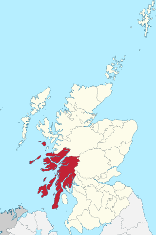
Argyll, sometimes called Argyllshire, is a historic county and registration county of western Scotland. The county ceased to be used for local government purposes in 1975 and most of the area now forms part of the larger Argyll and Bute council area.

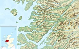
Kintyre is a peninsula in western Scotland, in the southwest of Argyll and Bute. The peninsula stretches about 30 miles, from the Mull of Kintyre in the south to East and West Loch Tarbert in the north. The region immediately north of Kintyre is known as Knapdale.

Loch Fyne, is a sea loch off the Firth of Clyde and forms part of the coast of the Cowal Peninsula. Located on the west coast of Argyll and Bute, west of Scotland. It extends 65 kilometres (40 mi) inland from the Sound of Bute, making it the longest of the sea lochs in Scotland. It is connected to the Sound of Jura by the Crinan Canal. Although there is no evidence that grapes have grown there, the title is probably honorific, indicating that the river, Abhainn Fìne, was a well-respected river.

The Trossachs generally refers to an area of wooded glens, braes, and lochs lying to the east of Ben Lomond in the Stirling council area of Scotland. The name is taken from that of a small woodland glen that lies at the centre of the area, but is now generally applied to the wider region.

Loch Shiel is a freshwater loch situated 20 kilometres (12 mi) west of Fort William in the Highland council area of Scotland. At 28 kilometres long it is the 4th longest loch in Scotland, and is the longest to have retained a natural outflow without any regulation of its water level, being 120 m (393 ft) deep. Its nature changes considerably along its length, being deep and enclosed by mountains in the north east and shallow surrounded by bog and rough pasture in the south west, from which end the 4 km River Shiel drains to the sea in Loch Moidart near Castle Tioram.

Loch Tummel is a long, narrow loch, seven kilometres northwest of Pitlochry in the council area of Perth and Kinross, Scotland. It is fed and drained by the River Tummel, which flows into the River Tay about 13 km (8 mi) south-east of the Clunie Dam at the loch's eastern end.
Ross-shire, or the County of Ross, was a county in the Scottish Highlands. It bordered Sutherland to the north and Inverness-shire to the south, as well as having a complex border with Cromartyshire, a county consisting of numerous enclaves or exclaves scattered throughout Ross-shire's territory. The mainland had a coast to the east onto the Moray Firth and a coast to the west onto the Minch. Ross-shire was named after and covered most of the ancient province of Ross, and also included the Isle of Lewis in the Outer Hebrides. The county town was Dingwall.

Slioch is a mountain in the Scottish Highlands situated in Wester Ross, eight kilometres north of the village of Kinlochewe. Slioch reaches an elevation of 981 metres and towers above the southeastern end of Loch Maree to give one of the best known and most photographed sights in the Highlands. VisitScotland, the Scottish national tourist agency, has used video footage of Slioch in its television advertisements.
The Clan Malcolm, also known as the Clan MacCallum, is a Highland Scottish clan. The Clan MacCallum may have originally been a separate clan until the 18th century, when the chief of the Clan MacCallum adopted the name Malcolm after inheriting the Malcolm estate, and the two clans were drawn together under the same chief.

Loch Dùghaill is a freshwater tidal loch on the River Carron in Wester Ross, Scotland. The A890 road and the Kyle of Lochalsh Line a branch of the Highland railway both run along its northwest shore. Loch Carron is located 8 km downriver.
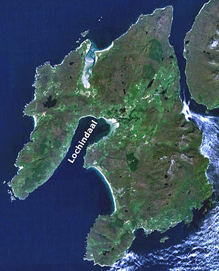
Loch Indaal is a sea loch on Islay, the southernmost island of the Hebrides, off the west coast of Scotland. Together with Loch Gruinart to the north, it was formed by the Loch Gruinart Fault, which branches off the Great Glen Fault.

Loch Broom is a sea loch located in northwestern Ross and Cromarty, in the former parish of Lochbroom, on the west coast of Scotland. The small town of Ullapool lies on the eastern shore of the loch.

Beinn Sgritheall or Beinn an Sgrithill, also anglicized Ben Sgriol, is the highest mountain on the Glenelg peninsula in the Northwest Highlands of Scotland. It is a Munro with a height of 974 metres (3,196 ft). The main approach is via Arnisdale on the shores of Loch Hourn or via Gleann Beag to the north, with its well-known brochs. The view from the summit was described by Sir Hugh Munro, a founder member of the Scottish Mountaineering Club, as "perhaps the most beautiful I have seen in Scotland".
Heasta, Heast, or the anglicised form Heaste, pron. /heɪst/, is a small settlement on the island of Skye, Scotland. It is located on the west coast of the island five miles south of Broadford extending down to the north shore of Loch Eiseort, facing out to the Atlantic to the south west and is in the Scottish council area of Highland.

Loch a' Mhadail or Loch a' Mhiotailt is a small freshwater lochan that lies immediately to the south-west of Loch Veyatie and is connected by a channel to Loch Veyatie within the area of Inverpolly. The channel measures about 20 foot in length, 10 feet in width and 1 foot in depth. When the water level is low, Loch a' Mhadail is separated from Loch Veyatie by a dyke made of Gneiss.

Loch an Nostarie is an irregular shaped shallow freshwater loch that lies about a mile north of the west-end of Loch Morar and about a mile south-east of Mallaig in the Lochaber district of Scotland. Loch an Nostarie drains through the little lochan Loch a' Mheadhoin through lochan Loch a' Bhada Dharaich flowing south along Allt an Lóin stream into Loch Morar. Directly to the south of the loch is Loch a' Ghille Ghobaich.