Related Research Articles

Cranham is a residential area of east London, and part of the London Borough of Havering. It is located 17.5 miles (28 km) east-northeast of Charing Cross and comprises an extensive built-up area to the north and a low density conservation area to the south surrounded by open land. It was historically a rural village in the county of Essex and formed an ancient parish. It is peripheral to London, forming the eastern edge of the urban sprawl. The economic history of Cranham is characterised by a shift from agriculture to housing development. As part of the suburban growth of London in the 20th century, Cranham significantly increased in population, becoming part of Hornchurch Urban District in 1934 and has formed part of Greater London since 1965. The 2011 Census population of Cranham was included in Upminster.

Harold Wood is a suburban neighbourhood in East London in the London Borough of Havering. It is situated 16.5 miles (26.6 km) east-northeast of Charing Cross. Harold Wood was part of the ancient parish of Hornchurch, which became the Liberty of Havering. Most of the current area of Harold Wood became part of Hornchurch Urban District in 1926. It is near to the Greater London boundary with Essex.

Hornchurch is a suburban town in East London in the London Borough of Havering. It is located 15.2 miles (24.5 km) east-northeast of Charing Cross. It comprises a number of shopping streets and a large residential area. It historically formed a large ancient parish in the county of Essex that became the manor and liberty of Havering. The economic history of Hornchurch is underpinned by a shift away from agriculture to other industries with the growing significance of nearby Romford as a market town and centre of administration. As part of the suburban growth of London in the 20th century, Hornchurch significantly expanded and increased in population, becoming an urban district in 1926 and has formed part of Greater London since 1965. It is the location of Queen's Theatre, Havering Sixth Form College and Havering College of Further and Higher Education.

Romford is a large town in east London, England, 14 miles (23 km) north-east of Charing Cross. Part of the London Borough of Havering, the town is one of the major metropolitan centres of Greater London identified in the London Plan.

The London Borough of Havering in East London, England, forms part of Outer London. It has a population of 259,552 inhabitants; the principal town is Romford, while other communities are Hornchurch, Upminster, Collier Row and Rainham. The borough is mainly suburban, with large areas of protected open space. Romford is a major retail and night time entertainment centre, and to the south the borough extends into the London Riverside redevelopment area of the Thames Gateway. The name Havering is a reference to the Royal Liberty of Havering which occupied the area for several centuries. The local authority is Havering London Borough Council. It is the easternmost London borough.
Gidea Park is a neighbourhood in the east of Romford in the London Borough of Havering, south-east England.

Collier Row is a neighbourhood to the north of Romford in East London, England, within the London Borough of Havering. It is a suburban development located 14 miles (23 km) northeast of Charing Cross.

Chadwell Heath is a town in East London, England. It is split between the London Borough of Barking and Dagenham and the London Borough of Redbridge, around 2 miles (3.2 km) west of Romford and 4 miles (6.4 km) east of Ilford, and 12 miles (19 km) north-east of Charing Cross.

In the United Kingdom, telephone numbers are administered by the Office of Communications (Ofcom). For this purpose, Ofcom established a telephone numbering plan, known as the National Telephone Numbering Plan, which is the system for assigning telephone numbers to subscriber stations.
In telecommunications, a long-distance call (U.S.) or trunk call is a telephone call made to a location outside a defined local calling area. Long-distance calls are typically charged a higher billing rate than local calls. The term is not necessarily synonymous with placing calls to another telephone area code.

Romford is a constituency represented in the House of Commons of the UK Parliament since 2001 by Andrew Rosindell, a Conservative. It was created in 1885 and was subject to significant changes in boundaries in 1918 and 1945. It initially covered a huge swathe of what is now East London, with parts of the constituency progressively removed as they experienced significant increases in population as London expanded. The constituency has more or less coincided with the town of Romford since 1955.

The Romford–Upminster line is a railway branch line in Greater London that connects Romford, on the Great Eastern Main Line, to Upminster, on the London, Tilbury and Southend line and London Underground. The route is 3 miles 28 chains (5.4 km) in length and there is one intermediate station at Emerson Park which is located 1 mile 62 chains (2.9 km) from Romford. The line is part of Network Rail Strategic Route 7, SRS 07.09, and is classified as a rural line.
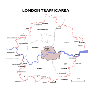
The London Traffic Area was established by the London Traffic Act 1924 to regulate the increasing amount of motor traffic in the London area. The LTA was abolished in 1965 on the establishment of the Greater London Council.

020 is the national dialling code for London in the United Kingdom. All subscriber numbers within the area code consist of eight digits and it has capacity for approaching 100 million telephone numbers. The code is used at 170 telephone exchanges in and around Greater London as part of the largest linked numbering scheme in the United Kingdom. In common with all other British area codes the initial '0' is a trunk prefix that is not required when dialling London from abroad.

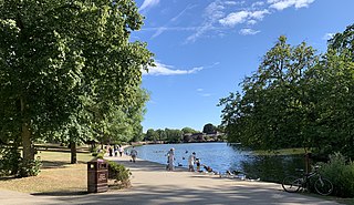
Raphael Park is a public park in Gidea Park, Romford, in the London Borough of Havering, United Kingdom. It is one of a series of parks stretching northwards from the railway line between Romford and Gidea Park.
There are various formal and informal subdivisions of London Borough of Barking and Dagenham and of parts of that borough.

Rainham is a suburb of East London, England, in the London Borough of Havering. Historically an ancient parish in the county of Essex, Rainham is 13.6 miles (21.9 km) east of Charing Cross and is surrounded by a residential area, which has grown from the historic village, to the north and a commercial area, fronting the River Thames, to the south. As part of the suburban growth of London in the 20th century, Rainham significantly expanded and increased in population, becoming part of Hornchurch Urban District in 1934, and has formed part of Greater London since 1965. The economic history of Rainham is underpinned by a shift from agriculture to industry and manufacture and is now in a period of regeneration, coming within the London Riverside section of the Thames Gateway redevelopment area.
01708 is the national dialling code for Romford in the United Kingdom. The area it serves includes almost all of the London Borough of Havering and some adjacent areas. When STD codes were first introduced, Romford was assigned 0708 and 0402 was used for the rest of the current code area. After a sequence of changes in the early 1990s, culminating with PhONEday, the current 01708 code became active on 16 April 1995. All subscriber numbers within the area code consist of six digits. The code is used at eight telephone exchanges as part a linked numbering scheme. In common with all other British area codes the initial '0' is a trunk prefix that is not required when dialling Romford from abroad.
Heath Park is an area of the London Borough of Havering situated to the east of Romford. It is a largely Edwardian estate built as a result of railway expansion.

St Michael's Church is a Church of England parish church on the Romford Road in Manor Park, east London.