Sequoia, Sequoya or Sequoyah may refer to:

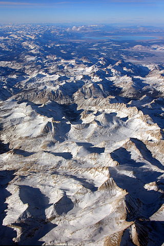
The Sierra Nevada is a mountain range in the Western United States, between the Central Valley of California and the Great Basin. The vast majority of the range lies in the state of California, although the Carson Range spur lies primarily in Nevada. The Sierra Nevada is part of the American Cordillera, an almost continuous chain of mountain ranges that forms the western "backbone" of the Americas.

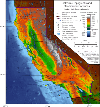
California is a U.S. state on the western coast of North America. Covering an area of 163,696 sq mi (423,970 km2), California is among the most geographically diverse states. The Sierra Nevada, the fertile farmlands of the Central Valley, and the arid Mojave Desert of the south are some of the major geographic features of this U.S. state. It is home to some of the world's most exceptional trees: the tallest, most massive, and oldest. It is also home to both the highest and lowest points in the 48 contiguous states. The state is generally divided into Northern and Southern California, although the boundary between the two is not well defined. San Francisco is decidedly a Northern California city and Los Angeles likewise a Southern California one, but areas in between do not often share their confidence in geographic identity. The US Geological Survey defines the geographic center of the state at a point near North Fork, California.

Inyo County is a county in the eastern central part of the U.S. state of California, located between the Sierra Nevada and the state of Nevada. In the 2020 census, the population was 19,016. The county seat is Independence. Inyo County is on the east side of the Sierra Nevada and southeast of Yosemite National Park in Central California. It contains the Owens River Valley; it is flanked to the west by the Sierra Nevada and to the east by the White Mountains and the Inyo Mountains. With an area of 10,192 square miles, Inyo is the second-largest county by area in California, after San Bernardino County. Almost one-half of that area is within Death Valley National Park. However, with a population density of 1.8 people per square mile, it also has the second-lowest population density in California, after Alpine County.

Scouting in California has a long history, from the 1910s to the present day, serving thousands of youth in programs related to their environments.

Northern California is a geographic and cultural region that generally comprises the northern portion of the U.S. state of California. Spanning the state's northernmost 48 counties, its main population centers include the San Francisco Bay Area, the Greater Sacramento area, the Redding, California, area south of the Cascade Range, and the Metropolitan Fresno area. Northern California also contains redwood forests, along with most of the Sierra Nevada, including Yosemite Valley and part of Lake Tahoe, Mount Shasta, and most of the Central Valley, one of the world's most productive agricultural regions.

Mount Whitney is the highest mountain in the contiguous United States and the Sierra Nevada, with an elevation of 14,505 feet (4,421 m). It is in East–Central California, on the boundary between California's Inyo and Tulare counties, 84.6 miles (136.2 km) west-northwest of North America's lowest point, Badwater Basin in Death Valley National Park, at 282 ft (86 m) below sea level. The mountain's west slope is in Sequoia National Park and the summit is the southern terminus of the John Muir Trail, which runs 211.9 mi (341.0 km) from Happy Isles in Yosemite Valley. The eastern slopes are in Inyo National Forest in Inyo County.
Buena Vista, meaning "good view" in Spanish, may refer to:

The 1872 Owens Valley earthquake – also known as the Lone Pine earthquake – struck on March 26 at in the Owens Valley, with the epicenter near the town of Lone Pine. Its magnitude has been estimated at 7.4 to 7.9, with a maximum Mercalli Intensity of X (Extreme). It was one of the largest earthquakes to hit California in recorded history and was similar in size to the 1906 San Francisco earthquake. Twenty-seven people were killed and fifty-six were injured.
The State Scenic Highway System in the U.S. state of California is a list of highways, mainly state highways, that have been designated by the California Department of Transportation (Caltrans) as scenic highways. They are marked by the state flower, a California poppy, inside either a rectangle for state-maintained highways or a pentagon for county highways.
Twin Peaks is an American television series, running from 1990 to 1991; and in 2017.
South Mountain or South Mountains may refer to:

Mount Tamalpais State Park is a California state park, located in Marin County, California. The primary feature of the park is the 2,571 feet (784 m) Mount Tamalpais. The park contains mostly redwood and oak forests. The mountain itself covers around 25,000 acres (100 km2). There are about 60 miles (97 km) of hiking trails, which are connected to a larger, 200 miles (320 km) network of trails in neighboring public lands. The park received 564,000 visitors in as of 2003. Muir Woods National Monument is surrounded by the state park.

The Coast Ranges of California span 400 miles (644 km) from Del Norte or Humboldt County, California, south to Santa Barbara County. The other three coastal California mountain ranges are the Transverse Ranges, Peninsular Ranges and the Klamath Mountains.

Mount Russell is a peak in the Sierra Nevada mountain range in the U.S. state of California, about 0.8 miles (1.3 km) north of Mount Whitney. With an elevation of 14,094 feet (4,296 m) it is the seventh-highest peak in the state.

Lone Mountain State Forest is a state forest in Morgan County, Tennessee, located in the southeastern United States. The forest consists of 3,624 acres (14.67 km2) managed by the Tennessee Department of Agriculture.

The Greater Sacramento area refers to a metropolitan region in Northern California comprising either the U.S. Census Bureau defined Sacramento–Roseville–Arden-Arcade metropolitan statistical area or the larger Sacramento–Roseville combined statistical area, the latter of which consists of seven counties, namely Sacramento, Yolo, Placer, El Dorado, Sutter, Yuba, and Nevada counties.

The following outline is provided as an overview of and topical guide to the U.S. state of California.


