
Araucaria is a genus of evergreen coniferous trees in the family Araucariaceae. There are 20 extant species in New Caledonia, Norfolk Island, eastern Australia, New Guinea, Argentina, Chile, Brazil, and northern Uruguay.

Pinus flexilis, the limber pine, is a species of pine tree-the family Pinaceae that occurs in the mountains of the Western United States, Mexico, and Canada. It is also called Rocky Mountain white pine.

Pinus ponderosa, commonly known as the ponderosa pine, bull pine, blackjack pine, or western yellow-pine, is a very large pine tree species of variable habitat native to the western United States and Canada. It is the most widely distributed pine species in North America.

Pawnee National Grassland is a United States National Grassland located in northeastern Colorado on the Colorado Eastern Plains. The grassland is located in the South Platte River basin in remote northern and extreme northeastern Weld County between Greeley and Sterling. It comprises two parcels totaling 193,060 acres (78,130 ha) largely between State Highway 14 and the Wyoming border. The larger eastern parcel lies adjacent to the borders of both Nebraska and Wyoming. It is administered in conjunction with the Arapaho-Roosevelt National Forest from the U.S. Forest Service office in Fort Collins, Colorado, with a local ranger district office in Greeley.

Custer National Forest is located primarily in the south central part of the U.S. state of Montana but also has separate sections in northwestern South Dakota. With a total area of 1,188,130 acres (4,808 km2), the forest comprises over 10 separate sections. While in the westernmost sections, Custer National Forest is a part of the Greater Yellowstone Ecosystem, the easternmost sections are a combination of forest "islands" and grasslands. A portion of the forest is also part of the Absaroka-Beartooth Wilderness and constitutes over a third of the wilderness land. South of Red Lodge, Montana, the Beartooth Highway passes through the forest en route to Yellowstone National Park.

Bitterroot National Forest comprises 1.587 million acres (6,423 km²) in west-central Montana and eastern Idaho, of the United States. It is located primarily in Ravalli County, Montana, but also has acreage in Idaho County, Idaho (29.24%), and Missoula County, Montana (0.49%).

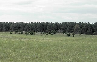
The Pine Ridge is an escarpment between the Niobrara River and the White River in far northwestern Nebraska. The high tableland between the rivers has been eroded into a region of forested buttes, ridges and canyons.

The Wildcat Hills are an escarpment between the North Platte River and Pumpkin Creek in the western Panhandle, in the state of Nebraska in the Great Plains region of the United States. Located in Banner, Morrill, and Scotts Bluff counties, the high tableland between the streams has been eroded by wind and water into a region of forested buttes, ridges and canyons that rise 150 to 300 m above the surrounding landscape.

The Welcome Creek Wilderness is located in the U.S. state of Montana. Created by an act of Congress in 1978, the wilderness is within Lolo National Forest, and protects the northern portion of the Sapphire Mountains.

The Nebraska National Forest is a United States National Forest located within the U.S. state of Nebraska. The total area of the national forest is 141,864 acres, or 222 sq miles. The forest is managed by the U.S. Forest Service's Nebraska Forests and Grasslands Supervisor's Office in Chadron, Nebraska. The national forest includes two ranger districts, the Bessey Ranger District and the Pine Ridge Ranger District. In descending order of land, the forest lies in parts of Thomas, Dawes, Blaine, and Sioux counties.
The Samuel R. McKelvie National Forest is a United States National Forest located in the north-central Sandhills region of the U.S. state of Nebraska. The total area of the national forest is 116,079 acres (469.76 km2). The forest is managed by the U.S. Forest Service's Nebraska Forests and Grasslands Supervisor's Office in Chadron, Nebraska. The national forest is located entirely within Cherry County, Nebraska. There is a local ranger district office located in Nenzel.
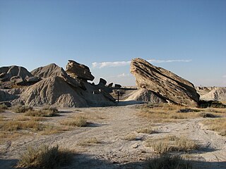
Toadstool Geologic Park is located in the Oglala National Grassland in far northwestern Nebraska. It is operated by the United States Forest Service. It contains a badlands landscape and a reconstructed sod house. The park is named after its unusual rock formations, many of which resemble toadstools.
The Pine Ridge National Recreation Area is a United States National Recreation Area located in the Pine Ridge region of northwestern Nebraska. The recreation area is managed by the Pine Ridge Ranger District of the Nebraska National Forest.

Little Pine State Park is a Pennsylvania state park on 2,158 acres (873 ha) in Cummings Township, Lycoming County, Pennsylvania in the United States. Little Pine State park is along 4.2 miles (6.8 km) of Little Pine Creek, a tributary of Pine Creek, in the midst of the Tiadaghton State Forest. A dam on the creek has created a lake covering 94 acres (38 ha) for fishing, boating, and swimming. The park is on Pennsylvania Route 4001, 4 miles (6.4 km) northeast of the unincorporated village of Waterville or 8 miles (13 km) southwest of the village of English Center. The nearest borough is Jersey Shore, Pennsylvania, about 15 miles (24 km) south at the mouth of Pine Creek on the West Branch Susquehanna River.
Sioux National Forest was established in Montana and South Dakota on July 1, 1908 with 249,653 acres (1,010.31 km2) from the consolidation of Cave Hills, Ekalaka, Long Pine, Short Pine and Slim Buttes National Forests. On January 13, 1920 the entire forest was absorbed by Custer National Forest and the name preserved as the Sioux District of Custer National Forest.
Long Pine National Forest was established as the Long Pine Forest Reserve in Montana on September 24, 1906 with 111,445 acres (451.00 km2). It became a National Forest on March 4, 1907. On July 1, 1908 it was absorbed by Sioux National Forest and the name was discontinued.

The Little Belt Mountains are a section of the Rocky Mountains in the U.S. state of Montana. Situated mainly in the Lewis and Clark National Forest, the mountains are used for logging and recreation for the residents of Great Falls, Montana. Showdown is a ski area located within the mountains located off US Highway 89 which splits the mountains in half connecting White Sulphur Springs and Belt, MT. The highest point in the Little Belt Range is Big Baldy Mountain at 9,175 feet (2,797 m).

The John Long Mountains, el. 7,923 feet (2,415 m), is a small mountain range northwest of Philipsburg, Montana in Granite County, Montana. The Beaverhead-Deerlodge National Forest and Lolo National Forest manage these mountains. A sizable roadless area of about 65,000 acres existed, as of 1990, in the John Long Mountains, centered on Silver King Mountain in the southern part of the range. It's unknown whether and to what extent this area's size has been reduced by logging. Lightly used trails traverse whitebark pine forests on the higher ridges, and forests of lodgepole pine, Douglas-fir, and heavy downfall on the eastern slopes. The western slopes have groves of douglas-fir amidst extensive grassy parks. Silver King Mountain is 7,581'.

Rhyacionia bushnelli, the western pine tip moth, is a moth of the Tortricidae family. It is found in the United States, including Alabama, Nebraska, North Dakota and Montana.
The following television stations broadcast on digital channel 4 in the United States:
