

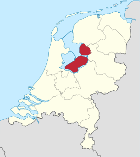
The Lopikerwaard is a polder landscape, located in the Dutch province of Utrecht.
The Lopikerwaard is a polder landscape, located in the Dutch province of Utrecht.
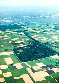
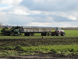
Originally an area of swampland, the polder was developed from the eleventh century CE. Many canals were dug in order to drain the land, dividing the land into equally sized plots which still define the landscape.
The polder area is bounded by the Hollandse IJssel river to the north and north east, the Lek river to the south and the Krimpenerwaard polder to the west. Several larger drainage canals cross the polder from east to west. The area largely coincides with the municipality of Lopik, whence it gets its name. The landscape is defined by large areas of pasture lands and linear settlements.
The cities of Oudewater, Montfoort and IJsselstein are located at the edges of the area.
The Lopikerwaard soil consists mainly of a thick layer of peat the thins out towards the east. At the edges, near the rivers, clay deposits can be found.
Flevoland is the 12th and youngest province of the Netherlands, established in 1986, when the Southern and Eastern Flevopolders, together with the Noordoostpolder were merged into one provincial entity. It is in the centre of the country in the former Zuiderzee, which was turned into the freshwater IJsselmeer by the closure of the Afsluitdijk in 1932. Almost all of the land belonging to Flevoland was reclaimed in the 1950s and 1960s while splitting the Markermeer and Bordering lakes from the IJsselmeer. As to dry land, it is the smallest province of the Netherlands at 1,412 km2 (545 sq mi), but not gross land as that includes much of the waters of the fresh water lakes (meres) mentioned. The province has a population of 423,021 as of January 2020 and consists of six municipalities. Its capital is Lelystad and its most populous city is Almere.
A polder is a low-lying tract of land that forms an artificial hydrological entity, enclosed by embankments known as dikes. The three types of polder are:
Belgium is a federal state located in Western Europe, bordering the North Sea. Belgium shares borders with France (556 km), Germany (133 km), Luxembourg (130 km) and the Netherlands (478 km). Belgium is divided into three regions: Flanders, Wallonia and Brussels.

The Zuiderzee Works is a man-made system of dams and dikes, land reclamation and water drainage work, in total the largest hydraulic engineering project undertaken by the Netherlands during the twentieth century. The project involved the damming of the Zuiderzee, a large, shallow inlet of the North Sea, and the reclamation of land in the newly enclosed water using polders. Its main purposes are to improve flood protection and create additional land for agriculture.

Lopik is a municipality and a town in the Netherlands, in the province of Utrecht, close to the Lek river.

Beemster is a municipality in the Netherlands, in the province of North Holland. The Beemster is the first so-called polder in the Netherlands that was reclaimed from a lake, the water being extracted from the lake by windmills. The Beemster Polder was dried during the period 1609 through 1612. It has preserved intact its well-ordered landscape of fields, roads, canals, dykes and settlements, laid out in accordance with classical and Renaissance planning principles. A grid of canals parallels the grid of roads in the Beemster. The grids are offset: the larger feeder canals are offset by approximately one kilometer from the larger roads.

The Upper Rhine is the section of the Rhine in the Upper Rhine Plain between Basel in Switzerland and Bingen in Germany. The river is marked by Rhine-kilometres 170 to 529.

Zuid-Beveland is part of the province of Zeeland in the Netherlands north of the Western Scheldt and south of the Eastern Scheldt.
This article is about the many neighborhoods and districts in the Greater Richmond, Virginia area. Note that this article is an attempt to be inclusive of the broader definitions of the areas which are often considered part of the Greater Richmond Region, based on their urban or suburban character and nature, rather than by strictly political boundaries.

The Ringvaart is a canal in the province of North Holland, the Netherlands. The Ringvaart is a true circular canal surrounding the Haarlemmermeer polder and forms the boundary of the Haarlemmermeer municipality. Ringvaart is also the name of the dike bordering the canal.

Vembanad, also known as Punnamada is the longest lake in India, as well as the largest lake in the state of Kerala. With an area of 2033 square kilometers and a maximum length of 96.5 km, it is the second largest Ramsar site in India only after the Sunderbans in West Bengal. Spanning several districts in the state of Kerala, it is known as Vembanadu Lake in Kottayam, Vaikom, Changanassery, Punnamada Lake in Alappuzha, Punnappra, Kuttanadu and Kochi Lake in Kochi. Several groups of small islands including Vypin, Mulavukad, Maradu, Udayamperoor, Vallarpadam, Willingdon Island are located in the Kochi Lake portion. Kochi Port is built around the Willingdon Island and the Vallarpadam island.
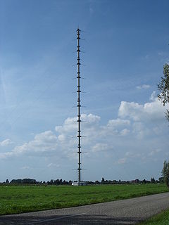
The KNMI-mast Cabauw is a 213-metre-high guyed mast for meteorological measurements at Cabauw, the Netherlands. In 1972 at Cabauw (06348) a 213 m high mast was specifically built for meteorological research to establish relations between the state of the atmospheric boundary layer (ABL), land surface conditions and the general weather situation for all seasons. The Cabauw mast is located in the western part of the Netherlands in a polder 0.7 m below average sealevel. This site was chosen, because it is rather representative for this part of the Netherlands and because only minor landscape developments were planned in this region. However, significant changes are the removal of the trees along a road east of the mast in 1975, and the building of houses in the village of Lopik east of the mast in more recent years.
The Holland Marsh is a wetland and agricultural area in Ontario, Canada, about 50 kilometres (31 mi) north of Toronto. It lies entirely within the valley of the Holland River, stretching from the northern edge of the Oak Ridges Moraine near Schomberg to the river mouth at Cook's Bay, Lake Simcoe. In its entirety it comprises about 21,000 acres, with two distinct divisions. Historically it has simply been referred to as "the marsh".

Sealand is a community in Flintshire and electoral ward, north-east Wales, on the edge of the Wirral peninsula. It is west of the city of Chester, England, and is part of the Deeside conurbation on the Wales-England border. At the 2001 Census, it had a population of 2,746, increasing to 2,996 at the 2011 census. The community includes the village of Garden City.

The Alblasserwaard is a polder in the province of South Holland, Netherlands. It is mainly known for the windmills of Kinderdijk, located near the village of Kinderdijk in the polder's northwestern part.

Salland is a historical dominion in the west and north of the present Dutch province of Overijssel. Nowadays Salland is usually used to indicate a region corresponding to the part of the former dominion more or less to the west of Twente.
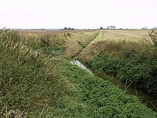
Flood control is an important issue for the Netherlands, as due to its low elevation, approximately two thirds of its area is vulnerable to flooding, while the country is densely populated. Natural sand dunes and constructed dikes, dams, and floodgates provide defense against storm surges from the sea. River dikes prevent flooding from water flowing into the country by the major rivers Rhine and Meuse, while a complicated system of drainage ditches, canals, and pumping stations keep the low-lying parts dry for habitation and agriculture. Water control boards are the independent local government bodies responsible for maintaining this system.
The River Foulness is a river in the East Riding of Yorkshire, England. Its name is derived from Old English fūle[n] ēa, meaning “dirty water”. Maintenance responsibilities for the river transferred from the Environment Agency to the Market Weighton Drainage Board on 1 October 2011. Market Weighton Drainage Board subsequently amalgamated with the Lower Ouse Internal Drainage Board on 1 April 2012 to create the Ouse and Humber Drainage Board. The river discharges into the Humber Estuary via Market Weighton Canal. Water levels within the river, its tributaries and the canal are managed and controlled by the Environment Agency. The river lies in an area known as the Humberhead Levels.
Międzyodrze is an area in Poland located in the Lower Odra Valley between two branches of the Oder River: West Oder and East Oder, a segment from the village Widuchowa to Iński Nurt channel. Międzyodrze area also includes islands located between the Oder and Dąbie Lake, as well as part of Szczecin.

The Sophia Polder is a polder to the south of Oostburg, Netherlands. It is one of a group of polders in the Ottevaere en Van Damme polder complex. A refuge for water birds, it has been a designated nature reserve since 2006.