National nature reserves in England were established by English Nature, now Natural England, which manages them either directly or through non-governmental organisations such as the Royal Society for the Protection of Birds or the National Trust.
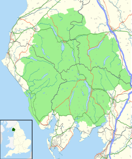
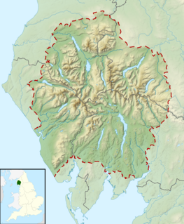
The Lake District, also known as the Lakes or Lakeland, is a mountainous region in North West England. A popular holiday destination, it is famous for its lakes, forests and mountains, and its associations with William Wordsworth and other Lake Poets and also with Beatrix Potter and John Ruskin. The National Park was established in 1951 and covers an area of 2,362 square kilometres. It was designated a UNESCO World Heritage Site in 2017.

Scafell Pike or is the highest mountain in England, at an elevation of 978 metres (3,209 ft) above sea level. It is located in the Lake District National Park, in Cumbria, and is part of the Southern Fells.

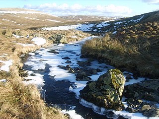
A fell is a high and barren landscape feature, such as a mountain range or moor-covered hills. The term is most often employed in Fennoscandia, the Isle of Man, parts of Northern England, and Scotland.

Scafell is a mountain in the English Lake District, part of the Southern Fells. Its height of 964 metres (3,162 ft) makes it the second-highest mountain in England after its neighbour Scafell Pike, from which it is separated by Mickledore col.

Whitbarrow is a hill in Cumbria, England. Designated a biological Site of Special Scientific Interest and national nature reserve, it forms part of the Morecambe Bay Pavements Special Area of Conservation due to its supporting some of the best European examples of natural limestone habitats. Also known as Whitbarrow Scar, the hill lies about 9 kilometres (5.6 mi) south-west of Kendal, just north of the A590 road, close to the village of Witherslack. Part of the site is a local nature reserve called Whitbarrow Scar.

High Raise is a fell in the Central Fells of the English Lake District, not to be confused with another High Raise situated in the Far Eastern Fells. High Raise is not one of the most spectacular mountains in the district; however, with a height of 762 metres (2,500 ft) it is the highest point in the central fells of Lakeland.

St Sunday Crag is a fell in the English Lake District, part of the Fairfield group in the Eastern Fells. It is a prominent feature in the Patterdale skyline, with a distinctive rounded shape. Indeed, it figures so finely in views from the upper reach of the lake that it is sometimes referred to as ‘the Ullswater Fell’.

Watch Hill is a small hill lying on the north-western fringe of the Lake District in England. The name Setmurthy Common is sometimes used to refer to the area including the highest point, with "Watch Hill" describing the area to the west of the summit. It should not be confused with another Watch Hill some 19 km to the south-west, near Whitehaven, which is only 172 m (564 ft) high. The name "The Hay" is also used when referring to the area west of the summit.
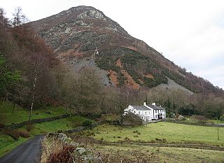
Barf is a fell in the north-western Lake District in Cumbria, UK. It stands on the south-western shore of Bassenthwaite Lake. Barf is well known for a whitewashed pillar of rock on the lower slopes, the so-called "Bishop's Rock" or "Bishop of Barf". The name is thought to be a derivative of "burgh".
Slate Fell is a low hill in the North Western part of the English Lake District. It lies only about a mile from the busy market town of Cockermouth, and as such is a popular walk for local dog walkers, the amount of climb being only about 80 metres (250 feet). A public right of way passes over the summit. It is an outlier of the Marilyn Watch Hill, and gives good views of the Lord's Seat group of hills, although it is too low to afford views towards the central Lake District. It lies just inside the boundary of the Lake District National Park.

Grisedale Pike is a fell in the Lake District, Cumbria, England situated 4.5 miles (7.2 km) west of the town of Keswick in the north-western sector of the national park. At a height of 791 m (2593 feet) it is the 40th-highest Wainwright in the Lake District; it also qualifies as a Hewitt, Marilyn and Nuttall. Grisedale Pike presents a striking appearance when viewed from the east, particularly from the vicinity of Keswick. It possesses two subsidiary summits: one unnamed ; the other Hobcarton End.

Sale Fell is a small hill near Cockermouth in the English Lake District. It is one of the smallest Wainwrights, but is nevertheless popular with locals, as it offers gentle walking and lovely views across Bassenthwaite Lake to Skiddaw.

Broom Fell is a small hill in the English Lake District. It lies on a ridge connecting Lord's Seat and Graystones, but is rarely climbed. Alfred Wainwright did however accord it the status of a separate fell in his influential guidebook series, the Pictorial Guide to the Lakeland Fells.

Whinlatter is a small fell in the north west of the English Lake District, just north of the Whinlatter Pass. It is easily climbed from the top of the Whinlatter Pass, through the Forestry Commission plantations. The Whinlatter Visitor's Centre, a popular tourist attraction, is on the south side of the fell. The hill is part of a horseshoe around the valley of Aiken Beck. The fell's name originates from a combination of the Old Norse and Gaelic languages. With the Old Norse word 'hvin' meaning gorse or furze, and the Gaelic word 'lettir' meaning slope, the name translates as "The Gorse or furze-covered slope.".

Ling Fell is a small hill in the north west of the Lake District in the United Kingdom. It is close to the village of Wythop Mill, from where it can easily be climbed. The fell is shaped like a wide dome, with no particular dangers. Its name derives from the fact that it is largely covered in heather, also known as "ling". The summit has good views of the town of Cockermouth.

The Outlying Fells of Lakeland is a book written by Alfred Wainwright, dealing with hills in and around the Lake District of England. It differs from Wainwright's Pictorial Guides in that each of its 56 chapters describes a walk, sometimes taking in several summits, rather than a single fell. This has caused some confusion on the part of authors attempting to prepare a definitive list of peaks. The Outlying Fells do not form part of the 214 hills generally accepted as making up the Wainwrights, but they are included in Category 2B of the Hill Walkers Register maintained by the Long Distance Walkers Association.

Seat or Seat (Buttermere) is a minor Fell in the English Lake District. It has a height of 561 m (1840 ft). Seat is over-shadowed by Haystacks and High Crag. Its location is on the south-western corner of Buttermere in the North Western Fells.
The Crookdale Horseshoe is a group of hills on the eastern edge of the English Lake District, in Cumbria, west of the A6 road. They are the subject of a chapter of Wainwright's book The Outlying Fells of Lakeland. Wainwright describes an anticlockwise walk starting along the valley of Crookdale Beck to reach Lord's Seat at 1,719 feet (524 m), and returning over Robin Hood at 1,613 feet (492 m) and High House Bank at 1,627 feet (496 m). As he points out, the ridge forming the northern part of the "horseshoe" is described in his Wasdale Horseshoe chapter.
