Related Research Articles

The Rio Grande is one of the principal rivers in the southwest United States and northern Mexico. The Rio Grande begins in south-central Colorado in the United States and flows to the Gulf of Mexico. After passing through the length of New Mexico along the way, it forms part of the Mexico–United States border. According to the International Boundary and Water Commission, its total length was 1,896 miles (3,051 km) in the late 1980s, though course shifts occasionally result in length changes. Depending on how it is measured, the Rio Grande is either the fourth- or fifth-longest river system in North America.

The Pecos River originates in north-central New Mexico and flows into Texas, emptying into the Rio Grande. Its headwaters are on the eastern slope of the Sangre de Cristo mountain range in Mora County north of Pecos, NM, at an elevation of over 12,000 feet (3,700 m) feet. The river flows for 926 miles (1,490 km) before reaching the Rio Grande near Del Rio. Its drainage basin encompasses about 44,300 square miles (115,000 km2).

The Brazos River, called the Río de los Brazos de Dios by early Spanish explorers, is the 11th-longest river in the United States at 1,280 miles (2,060 km) from its headwater source at the head of Blackwater Draw, Curry County, New Mexico to its mouth at the Gulf of Mexico with a 45,000-square-mile (116,000 km2) drainage basin. Being one of Texas' largest rivers, it is sometimes used to mark the boundary between East Texas and West Texas.

A spring is a point at which water flows from an aquifer to the Earth's surface. It is a component of the hydrosphere.
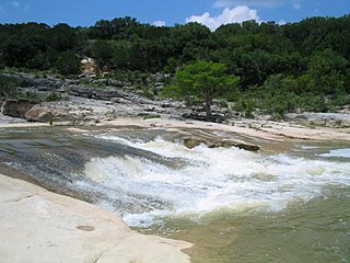
The Pedernales River is a tributary of the Colorado River, approximately 106 miles (171 km) long, in central Texas in the United States. It drains an area of the Edwards Plateau, flowing west to east across the Texas Hill Country west of Austin. The name "Pedernales", first used in the middle 18th century, comes from a Spanish word for the flint rocks characteristic of the riverbed.

Inks Lake State Park is a state park located in Burnet County, Texas, United States, next to Inks Lake on the Colorado River. The landscape of the park is hilly, with many cedar, live oak, prickly pear cacti, and yuccas. The ground is rocky, mainly consisting of gneiss rock.
Armand Bayou is a bayou in U.S. State of Texas. It runs near Galveston Bay in Pasadena and the Clear Lake Area.
The Atascosa River is a river tributary of the Frio River, which is tributary of the Nueces River in Texas.
Brady Creek is a river in Texas.
Coldwater Creek is an intermittently-flowing stream in northeastern New Mexico, and the panhandles of Oklahoma and Texas. As far back as 1907, the USGS reported that Coldwater Creek is a dry sand bed most of the year. One source says that Coldwater Creek is also known as Rabbit Ears Creek, because it rises near Rabbit Ears, a pair of mountain peaks in Union County, New Mexico. According to the United States Geological Survey (USGS), Coldwater Creek drains an area of 1,903 square miles (4,930 km2).
The Little Wichita River is a river in Texas.

Onion Creek is a small tributary stream of the Colorado River in Texas. It begins 12 mi (19 km) southeast of Johnson City, Blanco County, Texas, and flows approximately 79 mi (127 km) eastward into the Colorado River, 2 mi (3.2 km) northwest of Garfield in Travis County, Texas. While areas surrounding the creek's origin in Blanco County are primarily rural, areas closer to its mouth in Travis County have more urban and industrial development. Passing near Dripping Springs, Driftwood, and Onion Creek, Onion Creek is the source of the waterfalls in McKinney Falls State Park. Onion Creek's watershed spans an area of 211 sq mi (550 km2)

For the community in Brazoria County, Texas see: Oyster Creek, Texas.
Pecan Bayou is a slow-moving stream in Callahan County, Texas. The stream is fed by over twenty creeks and is one of the major tributaries of the Colorado River in Texas. It may be the westernmost bayou in the United States. A dam on Pecan Bayou seven miles north of Brownwood forms Lake Brownwood. Below Lake Brownwood, the stream flows through Brownwood and Early, Texas into western Mills county before the confluence with the Colorado River about 8 miles west of Goldthwaite, Texas.
Pine Island Bayou is a bayou in Texas.
The Sabinal River, formerly Arroyo de la Soledad, is a stream in Uvalde and Bandera counties of the U.S. state of Texas. The upper part of the river runs through the Lost Maples State Natural Area. In its lower section, it runs underground in some regions. The Sabinal River is fed by Hale, Hollow, and Can Creeks within Lost Maples State Natural Area and Mill, Little, Onion, Rancheros, Nolton, and East Elm Creeks in the lower region.

Central Texas is a region in the U.S. state of Texas surrounding Austin and roughly bordered by San Saba to Bryan and San Marcos to Hillsboro. Central Texas overlaps with and includes part of the Texas Hill Country and corresponds to a physiographic section designation within the Edwards Plateau, in a geographic context.

Clear Creek is a small river in Southeast Texas in the United States, which channels much of the run-off in southeast Harris County into Clear Lake and Galveston Bay. Much of the length of the stream forms the boundary between Harris County and Galveston County and all of the boundary with Brazoria County. It originates in the Blue Ridge Oilfield in Fort Bend County.
References
- "An Analysis of Texas Waterways" . Retrieved 2006-05-04.
- USGS Geographic Names Information Service
- USGS Hydrologic Unit Map - State of Texas (1974)
| This article related to a river in Texas is a stub. You can help Wikipedia by expanding it. |