Luis (disambiguation)

Last updated

Luis is a male given name. It can also refer to:

Luis (ᚂ) is the second letter of the Ogham alphabet, derived either from luise "flame" or from lus "herb". Its Proto-Indo-European root was either *leuk- 'to shine' or *leudh- 'to grow'. Its phonetic value is [l].

Luis is an American sitcom starring Luis Guzmán that aired on Fox from September to October 2003. Scheduled in the Friday night death slot, the series received low ratings and was canceled after five episodes. The series was the first show of the 2003-04 season to be canceled.

Luis Muñoz Marín International Airport airport near San Juan, Puerto Rico, USA

Luis Muñoz Marín International Airport is a joint civil-military international airport named for Puerto Rico's first democratically elected governor and located in suburban Carolina, Puerto Rico, three miles southeast of San Juan. It is the busiest airport in the Caribbean region by passenger traffic. Over 4 million passengers board a plane at the airport per year according to the Federal Aviation Administration.

Related Research Articles

Barbuda island in Antigua and Barbuda

Barbuda is a small island located in the eastern Caribbean forming part of the sovereign Commonwealth nation of Antigua and Barbuda. It is located north of the Antigua Island and is part of the Leeward Islands of the West Indies. Antigua and Barbuda became a sovereign nation on the 1st of November 1981 but remained part of the British Commonwealth and its constitutional monarchy. The island is a popular tourist destination because of its moderate climate and coastline.

East Coast of the United States Coastline in the United States

The East Coast of the United States, also known as the Eastern Seaboard, the Atlantic Coast, and the Atlantic Seaboard, is the coastline along which the Eastern United States meets the North Atlantic Ocean. The coastal states that have shoreline on the Atlantic Ocean are, from north to south, Maine, New Hampshire, Massachusetts, Rhode Island, Connecticut, New York, New Jersey, Delaware, Maryland, Virginia, North Carolina, South Carolina, Georgia, and Florida.

An IATA airport code, also known as an IATA location identifier, IATA station code or simply a location identifier, is a three-letter code designating many airports around the world, defined by the International Air Transport Association (IATA). The characters prominently displayed on baggage tags attached at airport check-in desks are an example of a way these codes are used.

Aero Virgin Islands

Aero Virgin Islands was an airline based in St. Thomas, US Virgin Islands.

ICAO airport code four-letter code designating many airports around the world

The ICAO airport code or location indicator is a four-letter code designating aerodromes around the world. These codes, as defined by the International Civil Aviation Organization and published in ICAO Document 7910: Location Indicators, are used by air traffic control and airline operations such as flight planning.

Ceiba, Puerto Rico Municipality of Puerto Rico (U.S.)

Ceiba is both a small town and municipality in northeast Puerto Rico (U.S.). It is named after the famous Ceiba tree. Ceiba is located in the north-east coast of the island, bordering the Atlantic Ocean, south of Fajardo, north of Naguabo and southeast of Río Grande. Located about one hour's driving distance from San Juan, Ceiba is spread over 7 wards and Ceiba Pueblo. It is part of the Fajardo Metropolitan Statistical Area.

Hurricane Lenny Category 4 Atlantic hurricane in 1999

Hurricane Lenny is the second-strongest November Atlantic hurricane on record, behind the 1932 Cuba hurricane. It was the twelfth tropical storm, eighth hurricane, and record-breaking fifth Category 4 hurricane in the 1999 Atlantic hurricane season. Lenny formed on November 13 in the western Caribbean Sea and maintained an unprecedented west-to-east track for its entire duration. It attained hurricane status south of Jamaica on November 15 and passed south of Hispaniola and Puerto Rico over the next few days. Lenny rapidly intensified over the northeastern Caribbean on November 17, attaining peak winds of 155 mph (249 km/h) about 21 mi (34 km) south of Saint Croix in the United States Virgin Islands. It gradually weakened while moving through the Leeward Islands, eventually dissipating on November 23 over the open Atlantic Ocean.
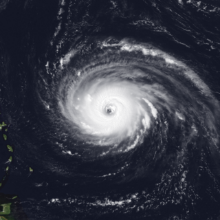
Patillas, Puerto Rico Municipality of Puerto Rico (U.S.)

Patillas is a municipality of Puerto Rico (U.S.) located in the southeastern coast, south of San Lorenzo; west of Yabucoa and Maunabo; and east of Guayama and Arroyo. It is spread over 15 wards and Patillas Pueblo. It is part of the Guayama Metropolitan Statistical Area.

Hurricane Luis Category 4 Atlantic hurricane in 1995

Hurricane Luis was a long-lived, powerful and a very destructive Cape Verde hurricane, as well as one of the strongest and most notable hurricanes of the 1995 Atlantic hurricane season, with maximum sustained winds of 140 mph (220 km/h) – which would nearly be tied with Opal later that year but surpassed it by minimum pressure. Luis was also the strongest hurricane to make landfall, and the third-most intense hurricane recorded during the extremely active season. It was the twelfth tropical storm, sixth hurricane, and second major hurricane of the season. At one point, the storm was one of four simultaneous tropical systems in the Atlantic basin, along with Humberto, Iris, and Karen. The storm lasted for 14 days as a tropical storm between late August and mid-September.

Hurricane Marilyn Category 3 Atlantic hurricane in 1995

Hurricane Marilyn was the most powerful hurricane to strike the Virgin Islands since Hurricane Hugo of 1989, and the third such tropical cyclone in roughly a two-week time span to strike or impact the Leeward Islands, the others being Hurricane Iris and the much more powerful and destructive Hurricane Luis. The thirteenth named storm, seventh hurricane and third major hurricane of the extremely active 1995 Atlantic hurricane season, Marilyn formed on September 12 as a tropical depression from a tropical wave that moved off the coast of Africa on September 7. After formation, the storm quickly became a tropical storm, and steadily intensified into a hurricane by the time it struck the Lesser Antilles on September 14 at Category 1 strength. Entering the northeastern Caribbean Sea, rapid intensification ensued and it peaked on September 16 north of Puerto Rico as a Category 3 hurricane shortly after it had impacted the U.S. Virgin Islands. A Hurricane Hunter reconnaissance flight reported hail, which is unusual for tropical cyclones. After heading north past Bermuda, Marilyn weakened and became extratropical on September 22. The remnant circulation wandered the Atlantic Ocean from September 23 – October 1, just south of Nova Scotia.

Cyril E. King Airport airport in the U.S. Virgin Islands

Cyril E. King International Airport is a public airport located two miles (3 km) west of the central business district of Charlotte Amalie on the island of St. Thomas in the United States Virgin Islands. It is currently the busiest airport in the United States Virgin Islands, and one of the busiest in the eastern Caribbean, servicing 1,403,000 passengers from July 2015 through June 2016. The airport also serves nearby St. John and is often used by those traveling to the British Virgin Islands.

Seaborne Airlines is a FAR Part 121 airline headquartered in San Juan, Puerto Rico. It was established in 1992 and operates domestic seaplane and land plane services. In late 2008, Seaborne Airlines began land based flight service between St. Thomas, St. Croix, and San Juan TJIG Isla Grande Airport under the brand name "Seaborne Airshuttle." In January 2011, Seaborne Airlines began service to San Juan TJSJ Luis Munoz Marin International Airport. On December 18, 2013, Seaborne announced a headquarters change from Christiansted, St. Croix to San Juan, Puerto Rico, completed by March 2014.

Hurricane Erika (1997) Category 3 Atlantic hurricane in 1997

Hurricane Erika was the strongest and longest-lasting tropical cyclone in the 1997 Atlantic hurricane season. It developed from a tropical wave on September 3 and moved west-northwestward across the tropical Atlantic Ocean, steadily intensifying until it attained hurricane status on September 4, becoming the fifth named storm and third hurricane of the season. Erika passed a short distance to the north of the Lesser Antilles, and later turned to the north in response to an approaching trough. The hurricane quickly strengthened to become the only major hurricane of the season, reaching maximum sustained winds of 125 mph (205 km/h) on September 8; after maintaining its peak strength for 24 hours, Erika began to weaken as it passed over cooler waters. It turned to the east, weakened to a tropical storm, and became extratropical after passing near the Azores archipelago.

A location identifier is a symbolic representation for the name and the location of an airport, navigation aid, or weather station, and is used for manned air traffic control facilities in air traffic control, telecommunications, computer programming, weather reports, and related services.

He or HE may refer to:

Aerovías Nacionales Quisqueyana, also known as Quisqueyana, was an airline from the Dominican Republic which was based at Las Américas International Airport, Santo Domingo, during the 1960s and 1970s. Offering mostly flights to the United States and to Europe, Quisqueyana was in direct competition with Dominicana, which at the time was the flag carrier of the country.

Meteorological history of Hurricane Luis

The meteorological history of Hurricane Luis spanned sixteen days between August 27 to September 11, 1995. The storm originated from an area of low pressure associated with a tropical wave on August 26. The following day, the low became sufficiently organized to be classified as a tropical depression, while tracking general westward. By August 29, the depression intensified into a tropical storm and was given the name Luis by the National Hurricane Center. Luis attained hurricane status the following day as an eye began to develop. On September 1 the cyclone intensified into a major hurricane—a storm with winds of 111 mph (178 km/h) or higher—and further strengthened to a Category 4 hurricane later that day.

Hurricane Maria Category 5 Atlantic hurricane in 2017

Hurricane Maria was a deadly Category 5 hurricane that devastated Dominica, the U.S. Virgin Islands, and Puerto Rico in September 2017. It is regarded as the worst natural disaster on record to affect those islands and is also the deadliest Atlantic hurricane since Jeanne in 2004. The tenth-most intense Atlantic hurricane on record and the most intense tropical cyclone worldwide in 2017, Maria was the thirteenth named storm, eighth consecutive hurricane, fourth major hurricane, second Category 5 hurricane, and deadliest storm of the hyperactive 2017 Atlantic hurricane season. At its peak, the hurricane caused catastrophic destruction and numerous fatalities across the northeastern Caribbean, compounding recovery efforts in the areas of the Leeward Islands already struck by Hurricane Irma. Total losses from the hurricane are estimated at upwards of $91.61 billion, mostly in Puerto Rico, ranking it as the third-costliest tropical cyclone on record.

Almost Like Praying single by Lin-Manuel Miranda

"Almost Like Praying" is a song written by Lin-Manuel Miranda and recorded by him and numerous other artists under the collective name Artists for Puerto Rico. The song was released on October 6, 2017, by Atlantic Records to support relief efforts in Puerto Rico in response to Hurricane Maria, which struck the island in September 2017. Proceeds from the song are to be donated to the victims and survivors of the hurricane. The song debuted at number 20 on the Billboard Hot 100 and number one on the Billboard Digital Songs Sales chart, selling 111,000 downloads and achieving 5.2 million streams in its first week of availability in the US. In February 2018, a salsa remix of the song was released.