Lärkstaden

Last updated
Larkstaden, Stockholm Larkstaden 2 22072006.jpg
Lärkstaden, Stockholm
Larkstaden, Stockholm Larkstaden 1 22072006.jpg
Lärkstaden, Stockholm
Larkstaden, Stockholm Larkstaden 3 22072006.jpg
Lärkstaden, Stockholm

Lärkstaden (Swedish for "Lark City") is an urban area within the city district of Östermalm in central Stockholm, Sweden.

Swedish language North Germanic language spoken in Sweden

Swedish is a North Germanic language spoken natively by 10 million people, predominantly in Sweden, and in parts of Finland, where it has equal legal standing with Finnish. It is largely mutually intelligible with Norwegian and to some extent with Danish, although the degree of mutual intelligibility is largely dependent on the dialect and accent of the speaker. Both Norwegian and Danish are generally easier for Swedish speakers to read than to listen to because of difference in accent and tone when speaking. Swedish is a descendant of Old Norse, the common language of the Germanic peoples living in Scandinavia during the Viking Era. It has the most speakers of the North Germanic languages.

Östermalm urban district in central Stockholm

Östermalm is a 2.56 km² large district in central Stockholm, Sweden. With 71,802 inhabitants it is one of the most populous districts in Stockholm. It's an extremely expensive area, having the highest housing prices in Sweden.

Stockholm Capital city in Södermanland and Uppland, Sweden

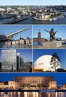
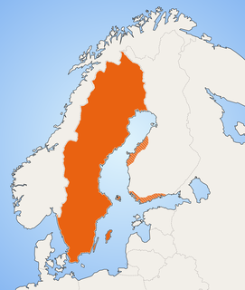
Stockholm is the capital of Sweden and the most populous urban area in the Nordic countries; 962,154 people live in the municipality, approximately 1.5 million in the urban area, and 2.3 million in the metropolitan area. The city stretches across fourteen islands where Lake Mälaren flows into the Baltic Sea. Just outside the city and along the coast is the island chain of the Stockholm archipelago. The area has been settled since the Stone Age, in the 6th millennium BC, and was founded as a city in 1252 by Swedish statesman Birger Jarl. It is also the capital of Stockholm County.

Contents

The name originates from the large block "Lärkan" which used to dominated the area before the present buildings were built in 1907. Many of the blocks added at this time were given names such as "piplärkan" pipit, "tofslärka" (Crested lark), "trädlärka" Woodlark, and other bird names. [1]

Pipit genus of birds

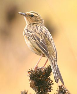
The pipits are a cosmopolitan genus, Anthus, of small passerine birds with medium to long tails. Along with the wagtails and longclaws, the pipits make up the family Motacillidae. The genus is widespread, occurring across most of the world, except the driest deserts, rainforests and the mainland of Antarctica.

Crested lark species of bird

The crested lark is a species of lark distinguished from the other 81 species of lark by the crest of feathers that rise up in territorial or courtship displays and when singing. Common to mainland Europe, the birds can also be found in northern Africa and in parts of western Asia and China. It is a non-migratory bird, but can occasionally be found as a vagrant in Great Britain.

Woodlark species of bird

The woodlark or wood lark is the only extant species in the lark genus Lullula. It is found across most of Europe, the Middle East, western Asia and the mountains of north Africa. It is mainly resident (non-migratory) in the west of its range, but eastern populations of this passerine bird are more migratory, moving further south in winter.

Though the area has no official extent, it is said to be delimited by the streets Odengatan, Karlavägen, Valhallavägen, and Uggelviksgatan, if nothing else because of the contrast between the small-scale character of the neighbourhood and the blocks surrounding it.

Odengatan street in Östermalm, Stockholm, Sweded

Odengatan is a major street in the districts Vasastan and Östermalm in central Stockholm.

Notes

  1. Stugart

Related Research Articles

Högdalen urban district in Stockholm, Sweden

Högdalen is a suburban district in South Stockholm, Sweden, built around the metro station with this name on line 19. It was connected to Stockholm City Centre in 1954, three years after the town planning of the Högdalen district was approved.

Kungsträdgården park in central Stockholm, Sweden

Kungsträdgården is a park in central Stockholm, Sweden. It is colloquially known as Kungsan.

Lilla Essingen is a small island in central Stockholm, Sweden, next to the larger neighbouring island Stora Essingen.

Kungsholmen island in the Lake Mälaren in Stockholm, Sweden

Kungsholmen is an island in Lake Mälaren in Sweden, part of central Stockholm. It is situated north of Riddarfjärden and considered part of the historical province Uppland. Its area is 3.9 km2 (1.5 sq mi) with a perimeter of 8.9 km (5.5 mi). The highest point is at Stadshagsplan at 47 metres (154 ft). The total population is 56,754.

Diplomatstaden area in Östermalm, Stockholm, Sweden

Diplomatstaden is a neighbourhood in the Östermalm district in central Stockholm, Sweden. As the name suggests, the neighborhood is the home of many embassies and ambassadorial residencies.

Vanhakaupunki Helsinki Subdivision in Uusimaa, Finland

Vanhakaupunki is a neighbourhood of the city of Helsinki, Finland, to the north of Toukola. It is also the name of a district of the city, which contains the neighbourhood and its surroundings. The name comes from the fact that Helsinki was originally founded in the Vanhakaupunki area. The Swedish name Gamla Helsingfors appears in the new Helsinki foundation document from 1639, as the city was moved to its later location, and the forms Gamla staden or Gammelstaden came into use after this. The Finnish translation of the name only started appearing in the late 19th century. The current names were established as official in 1909. The neighbourhood was named Vanhakaupunki in 1959.

Stora Nygatan street in Gamla stan, Stockholm, Sweden

Stora Nygatan is a street in Gamla stan, the old town in central Stockholm, Sweden. The troubadour Carl Michael Bellman lived at number 1 in 1785-1787 and at number 20 in 1787-88.

Kornhamnstorg is a public square in Gamla stan, the old town in central Stockholm, Sweden. Known as Kornhaffn (1427), Jernboen (1586), Åkaretorget (1644), and Kornhampns torget (1651), it is connected to the streets: Munkbroleden, Lilla Nygatan, Stora Nygatan, Torgdragargränd, Funckens Gränd, Triewaldsgränd.

Bollhustäppan is a small public space in Gamla stan, which is the old town in central Stockholm, Sweden. Named after Bollhuset, a historical theatre, it is located south of Slottsbacken just behind the Finnish Church, while two gates connects it to Trädgårdsgatan.

Göran Hälsinges Gränd alley in Gamla stan, Stockholm, Sweden

Göran Hälsinges Gränd is an alley in Gamla stan, the old town in central Stockholm, Sweden. Connecting Västerlånggatan to Stora Nygatan, it forms a parallel street to Helga Lekamens Gränd and Ignatiigränd.

Skeppar Olofs Gränd alley in Gamla stan, Stockholm, Sweden

Skeppar Olofs Gränd is an alley in Gamla stan, the old town in central Stockholm, Sweden. Stretching from Köpmangatan to Trädgårdsgatan, it forms a parallel street to Peder Fredags Gränd and Trädgårdstvärgränd.

Slussplan street in Gamla stan, Stockholm, Sweden

Slussplan is a street in Stockholm, Sweden. Located on the southern end of Gamla stan, the old town, and just north of Slussen and the public square Karl Johans Torg, it stretches west from Skeppsbron to Katarinavägen and Munkbroleden. South of the street is the statue of Charles XIV John, the creation of Bengt Erland Fogelberg and inaugurated in 1854. Järntorgsgatan leads north to the square Järntorget.

Staffan Sasses Gränd alley in Gamla stan, Stockholm, Sweden

Staffan Sasses Gränd is a blind alley in Gamla stan, the old town in central Stockholm, Sweden. Stretching north from Köpmangatan, it forms a parallel street to Bollhusgränd and Peder Fredags Gränd.

Sven Vintappares Gränd alley in Gamla stan, Stockholm, Sweden

Sven Vintappares Gränd is a small alley in Gamla stan, the old town of Stockholm, Sweden. Stretching from Västerlånggatan to Stora Nygatan, it forms a parallel street to Överskärargränd and Didrik Ficks Gränd, while passing on the north side of the small square Sven Vintappares Torg.

Benickebrinken street in Gamla stan, Stockholm, Sweden

Södra/Norra Benickebrinken are two sloping streets in Gamla stan, the old town in central Stockholm, Sweden, stretching from Österlånggatan up to Svartmangatan.

Peder Fredags Gränd alley in Gamla stan, Stockholm, Sweden

Peder Fredags Gränd is a small blind alley in Gamla stan, the old town in central Stockholm, Sweden. Stretching north from Köpmangatan, it is located between Skeppar Olofs Gränd and Staffan Sasses Gränd, just south of the Tessin Palace.

Abrahamsberg urban district in Stockholm, Sweden

Abrahamsberg is a residential district in the Västerort section of Stockholm municipality, Sweden, and part of the Bromma borough. It is bordered by Riksby, Stora Mossen, Ålsten, Olovslund and Åkeslund and is served by the Abrahamsberg metro station. The district was developed with small blocks of flats in yellow brick, and is therefore sometimes called den gula staden. As of December 2013 it had 3,154 residents.

Tallkrogen urban district in Stockholm, Sweden

Tallkrogen is a suburban city district located south of central Stockholm, Sweden, but within the Stockholm Municipality.

Götgatan street in Södermalm, Stockholm, Sweden

Götgatan is the name of one of the longest streets in central Stockholm on the Southern Isle (Södermalm) of the city. The street itself has existed since the 12th century, and has had its name since the 1640s, the name based on it being a part of the old Göta highway.

Västermalmsgallerian a shopping centre in Kungsholmen, Stockholm, Sweden, inaugurated on 23 August 2002

Västermalmsgallerian is a shopping centre in Kungsholmen, Stockholm, Sweden, inaugurated on 23 August 2002.

References

<i>Dagens Nyheter</i> Swedish newspaper

Dagens Nyheter, abbreviated DN, is a daily newspaper in Sweden. It is published in Stockholm and aspires to full national and international coverage.

Coordinates: 59°20′43.35″N18°4′2.88″E / 59.3453750°N 18.0674667°E / 59.3453750; 18.0674667

Geographic coordinate system Coordinate system

A geographic coordinate system is a coordinate system that enables every location on Earth to be specified by a set of numbers, letters or symbols. The coordinates are often chosen such that one of the numbers represents a vertical position and two or three of the numbers represent a horizontal position; alternatively, a geographic position may be expressed in a combined three-dimensional Cartesian vector. A common choice of coordinates is latitude, longitude and elevation. To specify a location on a plane requires a map projection.