The Menai Strait is a narrow stretch of shallow tidal water about 25 km (16 mi) long, which separates the island of Anglesey from the mainland of Wales.
The A487, officially also known as the Fishguard to Bangor Trunk Road, is a trunk road in Wales, running up the western side of the country from Haverfordwest, Pembrokeshire in the south to Bangor, Gwynedd in the north.

Caernarfon Bay is an inlet of the Irish Sea defined by the Llŷn peninsula and Anglesey.

Coleg Meirion-Dwyfor, also known as CMD, is a college in Gwynedd, Wales with its main campus in Dolgellau. It serves the areas of Meirionydd and Dwyfor. It has a bilingual language policy and offers the opportunity to study most subjects through the medium of Welsh. Since 1 April 2012, it has been a constituent college of Grŵp Llandrillo Menai.
Afon Seiont is a river in Gwynedd, Wales which runs into the Menai Strait.
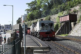
Caernarfon Station is the northern terminus of the narrow gauge Welsh Highland Railway, located in the town of Caernarfon. It was opened on 11 October 1997 when the line was constructed from Dinas.

The Celtic Trail is a network of dedicated cycle routes in the National Cycle Network, crossing West, South and Mid Wales, and covering 377 miles in total. It is divided into east and west sections. The west section links Pembroke and Fishguard on the west coast to Swansea, and the east section covers the area from Swansea to Chepstow, Abergavenny and Hay-on-Wye in the east. It is largely traffic free but sections along the route are still being upgraded and improved. In some places there is a choice of a low-level route, or a high-level route for mountain bikes.
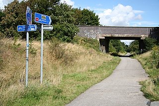
Lôn Eifion is part of Lôn Las Cymru, the Welsh National Cycle Route, which is about 400 km (250 mi) long.

The Mawddach Trail is a cycle path route, part of Lôn Las Cymru, which runs for some 8 miles (13 km) from Dolgellau (52.7446°N 3.8866°W) to Morfa Mawddach railway station (52.7076°N 4.0315°W), by Barmouth bridge on the Cambrian coast. It is maintained by the Snowdonia National Park and is popular with walkers and cyclists alike. It passes some estuarine areas that are important for water birds, and the RSPB Information Centre at Penmaenpool makes use of the old signal box as an observation centre overlooking the estuary.
National Cycle Network, Route 43 is part of the National Cycle Network and the Celtic Trail, which connects Swansea with Builth Wells. Most of the route is still awaiting development. As of June 2006, there is a 13-mile section out of Swansea that is open and signed.

National Cycle Route 8 is a route of the National Cycle Network, running from Cardiff to Holyhead. The route passes through the heart of Wales, and is also known by its Welsh name Lôn Las Cymru. It is largely north-south from Holyhead to Cardiff or Chepstow, and in total measures some 400 km (250 mi) in length. Some of its route follows the trackbed of former railway lines, such as Lôn Las Menai, Lôn Eifion, the Mawddach Trail and the Taff Trail; in other places, the route is on public highways. A road bike with racing tyres would struggle on the former surfaces; a hybrid or 'hard tail' mountain bike fitted with wide road tyres would be a better choice.

The A4080 is a British A road which is located on the Island of Anglesey, Wales. It follows a very roundabout route from the A5 road at Llanfairpwllgwyngyll via Newborough and Rhosneigr back to the A55 and the A5 about 9 miles south of Holyhead. In all the road is about 17 miles long.

The Ystwyth Trail is a 21-mile (34 km) multi-use rail trail linking Aberystwyth, Llanfarian, Ystrad Meurig and Tregaron in Ceredigion, Wales. Cycling and walking are permitted along the entire length while horseriding is permitted on several sections only.
National Cycle Network (NCN) Route 66 is a Sustrans National Route that runs from Kingston upon Hull to Manchester via Beverley, York and Leeds.
Menai Bridge railway station was situated 2 mi (3.2 km) west of Bangor, Gwynedd in Wales.
Grŵp Llandrillo Menai is an umbrella organisation to oversee the operation of the three member colleges: Coleg Llandrillo, Coleg Menai and Coleg Meirion-Dwyfor. Its first day of operation was Monday, 2 April 2012.
Lôn Las Ogwen is a 17.7 km (11.0 mi) cycle route in the National Cycle Network which runs south from the NCN 5 at Porth Penrhyn on the north coast of Wales to Llyn Ogwen in Snowdonia. Lôn Las Ogwen is Welsh for "Green Lane".
National Cycle Network (NCN) Route 64 is a Sustrans National Route that runs from Market Harborough to Lincoln. The route is 68 miles (109 km) in length and is fully open and signed in both directions. There are three sections to the route, NCN 63 and NCN 15 form the links between these sections.