M23, M.23 or M-23 may refer to:
A Pure Michigan Byway is the designation for a segment of the State Trunkline Highway System in the US state of Michigan that is a "scenic, recreational, or historic route that is representative of Michigan's natural and cultural heritage." The designation was created with the name Michigan Heritage Route by the state legislature on June 22, 1993, and since then six historic, seven recreational and seven scenic byways have been designated by the Michigan Department of Transportation (MDOT), and another two have been proposed. These byways have been designated in both the Upper and Lower peninsulas of the state. The current name was adopted on December 30, 2014, and it references the Pure Michigan tourism marketing campaign.

M-28 is an east–west state trunkline highway that traverses nearly all of the Upper Peninsula of the U.S. state of Michigan, from Wakefield to near Sault Ste. Marie in Bruce Township. Along with US Highway 2 (US 2), M-28 forms a pair of primary highways linking the Upper Peninsula from end to end, providing a major access route for traffic from Michigan and Canada along the southern shore of Lake Superior. M-28 is the longest state trunkline in Michigan numbered with the "M-" prefix at 290.373 miles (467.310 km). The entire highway is listed on the National Highway System, while three sections of M-28 are part of the Lake Superior Circle Tour. M-28 also carries two memorial highway designations along its route.

US Highway 16 (US 16), also called Grand River Avenue for much of its length in the state, was one of the principal roads prior to the post-World War II construction of freeways in the state of Michigan. Before the creation of the United States Numbered Highway System in 1926, the highway had been designated as a state highway numbered M-16. The modern route of Grand River Avenue cuts across the Lower Peninsula in a northwest–southeast fashion from near Grand Rapids to Detroit. Before the late 1950s and early 1960s, US 16 followed other roads between Muskegon and Grand Rapids, and then Grand River Avenue through Lansing to Detroit. In the years immediately preceding the creation of the Interstate Highway System, US 16 was shifted from older roads to newer freeways. Later, it was co-designated as an Interstate. When the gap in the freeway was filled in around Lansing, the US 16 designation was decommissioned in the state. The freeway was solely designated Interstate 96 (I-96) east of Grand Rapids and I-196 west of that city.

A concurrency in a road network is an instance of one physical roadway bearing two or more different route numbers. When two roadways share the same right-of-way, it is sometimes called a common section or commons. Other terminology for a concurrency includes overlap, coincidence, duplex, triplex, multiplex, dual routing or triple routing.
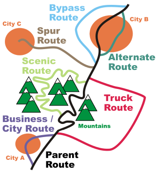
A business route in the United States is a short special route that branches off a parent numbered highway at its beginning, continues through the central business district of a nearby city or town, and finally reconnects with the same parent numbered highway at the business route's end. Their designation is often intended to direct traffic to the business districts bypassed when a new highway is constructed some distance away.

Interstate 275 (I-275) is an auxiliary Interstate Highway in the US state of Michigan that acts as a western bypass of the Detroit metropolitan area. The Michigan Department of Transportation (MDOT) maintains the highway as part of the larger State Trunkline Highway System. The freeway runs through the western suburbs near Detroit Metropolitan Wayne County Airport, and crosses several rivers and rail lines in the area. The southern terminus is the interchange with I-75 near Newport, northeast of Monroe. MDOT considers the Interstate to run to an interchange with I-96, I-696 and M-5 on the Farmington Hills–Novi city line, running concurrently with I-96 for about five miles (8.0 km). This gives a total length of about 35.03 miles (56.38 km), which is backed up by official signage. According to the Federal Highway Administration (FHWA), the length is 29.97 miles (48.23 km) because that agency considers I-275 to end at the junction with I-96 and M-14 along the boundary between Livonia and Plymouth Township. All other map makers, like the American Automobile Association, Rand McNally and Google Maps follow MDOT's practice.
Veterans Memorial Highway is the name chosen for the following roads:
There have been three different highways in the U.S. state of Michigan to bear the designation, Business M-28 or BUS M-28, M-28BR.
M-144 was the designation given to two former state trunkline highways in the U.S. state of Michigan:
M-111 was the designation given to two former state trunklines in the U.S. state of Michigan:
M-174 was the designation given to two former state trunklines in the U.S. state of Michigan:
M-213 was a state highway route designation in the U.S. state of Michigan that was used twice:
M-151, was formerly the designation of two different state trunkline highways in the US state of Michigan.

US Highway 12 (US 12) is an east–west United States Numbered Highway that runs from Aberdeen, Washington, to Detroit, Michigan. In Michigan, it runs for 210 miles (340 km) between New Buffalo and Detroit as a state trunkline highway and Pure Michigan Byway. On its western end, the highway is mostly a two-lane road that runs through the southern tier of counties roughly parallel to the Indiana state line. It forms part of the Niles Bypass, a four-lane expressway south of Niles in the southwestern part of the state, and it runs concurrently with the Interstate 94 (I-94) freeway around the south side of Ypsilanti in southeastern Michigan. In between Coldwater and the Ann Arbor area, the highway angles northeasterly and passes Michigan International Speedway. East of Ypsilanti, US 12 follows a divided highway routing on Michigan Avenue into Detroit, where it terminates at an intersection with Cass Avenue.

US Highway 23 (US 23) is a north–south United States Numbered Highway that runs from Jacksonville, Florida, to Mackinaw City, Michigan. In the US state of Michigan, it is a major, 362-mile-long (583 km), north–south state trunkline highway that runs through the Lower Peninsula. The trunkline is a freeway from the Michigan–Ohio state line near Lambertville to the city of Standish, and it follows the Lake Huron shoreline from there to its northern terminus. Serving the cities of Ann Arbor and Flint, US 23 acts as a freeway bypass of the Metro Detroit area. Overall, the highway runs through rural areas of the state dominated by farm fields or woodlands; some segments are urban in character in the Ann Arbor, Flint and Tri-Cities areas. The section from Flint north to Standish also carries Interstate 75 (I-75) along a concurrency that includes a segment that carries almost 70,000 vehicles on a daily basis.

US Highway 41 (US 41) is a part of the United States Numbered Highway System that runs from Miami, Florida, to the Upper Peninsula of the US state of Michigan. In Michigan, it is a state trunkline highway that enters the state via the Interstate Bridge between Marinette, Wisconsin, and Menominee, Michigan. The 278.769 miles (448.635 km) of US 41 that lie within Michigan serve as a major conduit. Most of the highway is listed on the National Highway System. Various sections are rural two-lane highway, urbanized four-lane divided expressway and the Copper Country Trail National Scenic Byway. The northernmost community along the highway is Copper Harbor at the tip of the Keweenaw Peninsula. The trunkline ends at a cul-de-sac east of Fort Wilkins State Park after serving the Central Upper Peninsula and Copper Country regions of Michigan.

The State Trunkline Highway System consists of all the state highways in Michigan, including those designated as Interstate, United States Numbered, or State Trunkline highways. In their abbreviated format, these classifications are applied to highway numbers with an I-, US, or M- prefix, respectively. The system is maintained by the Michigan Department of Transportation (MDOT) and comprises 9,669 miles (15,561 km) of trunklines in all 83 counties of the state on both the Upper and Lower peninsulas, which are linked by the Mackinac Bridge. Components of the system range in scale from 10-lane urban freeways with local-express lanes to two-lane rural undivided highways to a non-motorized highway on Mackinac Island where cars are forbidden. The longest highway is nearly 400 miles (640 km) long, while the shortest is about three-quarters of a mile. Some roads are unsigned highways, lacking signage to indicate their maintenance by MDOT; these may be remnants of highways that are still under state control whose designations were decommissioned or roadway segments left over from realignment projects.
M-56 was the designation given to two former state trunkline highways in the U.S. state of Michigan:
