Theory
As most other models made by DHI, MIKE 21C applies an add-on concept in which the overall time-loop can contain processes to be simulated, selected by the user. In its basic form the model is a 2-dimensional hydrodynamic model that can simulate dynamic as well as quasi-steady or steady-state hydrodynamic solutions. The hydrodynamic model solves the Saint-Venant equations in two dimensions with the water depth defined in cell centers and a staggered velocity field (internally the code solves the flux field, i.e. the water depth multiplied by the velocity vector) defined with direction as the local grid base vector.
The model is computationally a parallel code (written in Fortran) with parallelizations in all modules, which allows for simulations of morphological developments on fine grids over long periods of time. The model is typically applied with as much 25,000 computational points over periods of several years or even decades.
The most important secondary flow in rivers is the so-called helical flow, with its name derived from Helios (the Sun in Greek). The name helical is used because the flow arises as the water in the lower portions of the water column flowing towards the local center of curvature, and away from the local center of curvature along the water surface. This has only a minor impact on the hydrodynamics, usually only pronounced on a laboratory scale, but it has profound impacts on the sediment transport and morphology because the helical flow influences the otherwise zero transverse sediment component. MIKE 21C applies standard theory for the helical flow, which can be found in e.g. Rozowsky (1957). Standard helical flow theory provides a secondary flow velocity profile that is fully characterised by friction and the deviation angle between the main flow direction and the direction of the shear stress at the river bed.
MIKE 21C uses the traditional division of sediment transport into bedload and suspended load, and the model can simulate both non-cohesive and cohesive sediment in a mixture.
The bed-load model accounts for the impacts of secondary flow (bed shear stress direction) and local bed slope (gravity). Suspended load is calculated with an advection-dispersion equation for each fraction, which includes adaptation in time and space as well as the 2-dimensional depth-integrated effects of the 3-dimensional flow pattern through profile functions (Galappatti & Vreugdenhil, 1985).

In geography and geology, fluvial sediment processes or fluvial sediment transport are associated with rivers and streams and the deposits and landforms created by sediments. It can result in the formation of ripples and dunes, in fractal-shaped patterns of erosion, in complex patterns of natural river systems, and in the development of floodplains and the occurrence of flash floods. Sediment moved by water can be larger than sediment moved by air because water has both a higher density and viscosity. In typical rivers the largest carried sediment is of sand and gravel size, but larger floods can carry cobbles and even boulders. When the stream or rivers are associated with glaciers, ice sheets, or ice caps, the term glaciofluvial or fluvioglacial is used, as in periglacial flows and glacial lake outburst floods. Fluvial sediment processes include the motion of sediment and erosion or deposition on the river bed.

A wave tank is a laboratory setup for observing the behavior of surface waves. The typical wave tank is a box filled with liquid, usually water, leaving open or air-filled space on top. At one end of the tank, an actuator generates waves; the other end usually has a wave-absorbing surface. A similar device is the ripple tank, which is flat and shallow and used for observing patterns of surface waves from above.
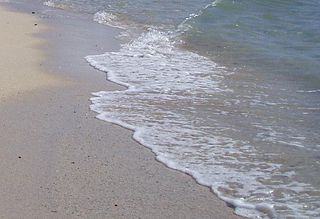
Swash, or forewash in geography, is a turbulent layer of water that washes up on the beach after an incoming wave has broken. The swash action can move beach materials up and down the beach, which results in the cross-shore sediment exchange. The time-scale of swash motion varies from seconds to minutes depending on the type of beach. Greater swash generally occurs on flatter beaches. The swash motion plays the primary role in the formation of morphological features and their changes in the swash zone. The swash action also plays an important role as one of the instantaneous processes in wider coastal morphodynamics.

A meander is one of a series of regular sinuous curves in the channel of a river or other watercourse. It is produced as a watercourse erodes the sediments of an outer, concave bank and deposits sediments on an inner, convex bank which is typically a point bar. The result of this coupled erosion and sedimentation is the formation of a sinuous course as the channel migrates back and forth across the axis of a floodplain.

An hydrological transport model is a mathematical model used to simulate the flow of rivers, streams, groundwater movement or drainage front displacement, and calculate water quality parameters. These models generally came into use in the 1960s and 1970s when demand for numerical forecasting of water quality and drainage was driven by environmental legislation, and at a similar time widespread access to significant computer power became available. Much of the original model development took place in the United States and United Kingdom, but today these models are refined and used worldwide.

In geology, cross-bedding, also known as cross-stratification, is layering within a stratum and at an angle to the main bedding plane. The sedimentary structures which result are roughly horizontal units composed of inclined layers. The original depositional layering is tilted, such tilting not being the result of post-depositional deformation. Cross-beds or "sets" are the groups of inclined layers, which are known as cross-strata.

Sediment transport is the movement of solid particles (sediment), typically due to a combination of gravity acting on the sediment, and the movement of the fluid in which the sediment is entrained. Sediment transport occurs in natural systems where the particles are clastic rocks, mud, or clay; the fluid is air, water, or ice; and the force of gravity acts to move the particles along the sloping surface on which they are resting. Sediment transport due to fluid motion occurs in rivers, oceans, lakes, seas, and other bodies of water due to currents and tides. Transport is also caused by glaciers as they flow, and on terrestrial surfaces under the influence of wind. Sediment transport due only to gravity can occur on sloping surfaces in general, including hillslopes, scarps, cliffs, and the continental shelf—continental slope boundary.

The shallow-water equations (SWE) are a set of hyperbolic partial differential equations that describe the flow below a pressure surface in a fluid. The shallow-water equations in unidirectional form are also called Saint-Venant equations, after Adhémar Jean Claude Barré de Saint-Venant.
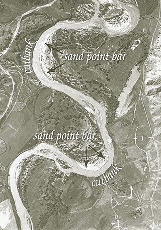
A point bar is a depositional feature made of alluvium that accumulates on the inside bend of streams and rivers below the slip-off slope. Point bars are found in abundance in mature or meandering streams. They are crescent-shaped and located on the inside of a stream bend, being very similar to, though often smaller than, towheads, or river islands.

Sedimentary structures include all kinds of features in sediments and sedimentary rocks, formed at the time of deposition.
MIKE 11 is a computer program that simulates flow and water level, water quality and sediment transport in rivers, flood plains, irrigation canals, reservoirs and other inland water bodies. MIKE 11 is a 1-dimensional river model. It was developed by DHI.
MIKE 21 is a computer program that simulates flows, waves, sediments and ecology in rivers, lakes, estuaries, bays, coastal areas and seas in two dimensions. It was developed by DHI.
GSSHA is a two-dimensional, physically based watershed model developed by the Engineer Research and Development Center of the United States Army Corps of Engineers. It simulates surface water and groundwater hydrology, erosion and sediment transport. The GSSHA model is used for hydraulic engineering and research, and is on the Federal Emergency Management Agency (FEMA) list of hydrologic models accepted for use in the national flood insurance program for flood hydrograph estimation. Input is best prepared by the Watershed Modeling System interface, which effectively links the model with geographic information systems (GIS).

Bridge scour is the removal of sediment such as sand and gravel from around bridge abutments or piers. Hydrodynamic scour, caused by fast flowing water, can carve out scour holes, compromising the integrity of a structure.

A bedform is a geological feature that develops at the interface of fluid and a moveable bed, the result of bed material being moved by fluid flow. Examples include ripples and dunes on the bed of a river. Bedforms are often preserved in the rock record as a result of being present in a depositional setting. Bedforms are often characteristic to the flow parameters, and may be used to infer flow depth and velocity, and therefore the Froude number.
A mouth bar is an element of a deltaic system, which refers to the typically mid-channel deposition of the sediment transported by the river channel at the river mouth.

SHETRAN is a hydrological modelling system for water flow, solute and sediment transport in river catchments. SHETRAN is a physically based, distributed model (PBDM) that can simulate the entire land phase of the hydrologic cycle including surface water flow and groundwater flow. The plan area of the catchment in SHETRAN is usually in the range of one to a few thousand square kilometres and the horizontal depth of the subsurface is usually less than 100m.

In computational fluid dynamics, TELEMAC is short for the open TELEMAC-MASCARET system, or a suite of finite element computer program owned by the Laboratoire National d'Hydraulique et Environnement (LNHE), part of the R&D group of Électricité de France. After many years of commercial distribution, a Consortium was officially created in January 2010 to organize the open source distribution of the open TELEMAC-MASCARET system now available under GPLv3.

Jørgen Fredsøe (1947) is a Danish hydraulic engineer who is recognized for his contributions within bed form dynamics in rivers and the marine environment and coastal morphology including bars and beach undulations. Together with professor B. Mutlu Sumer he initiated the research on scour (erosion) in the seabed around coastal structures applying detailed hydrodynamic interpretations. He was born in Randers, Denmark.

Ecohydraulics is an interdisciplinary science studying the hydrodynamic factors that affect the survival and reproduction of aquatic organisms and the activities of aquatic organisms that affect hydraulics and water quality. Considerations include habitat maintenance or development, habitat-flow interactions, and organism responses. Ecohydraulics assesses the magnitude and timing of flows necessary to maintain a river ecosystem and provides tools to characterize the relation between flow discharge, flow field, and the availability of habitat within a river ecosystem. Based on this relation and insights into the hydraulic conditions optimal for different species or communities, ecohydraulics-modeling predicts how hydraulic conditions in a river change, under different development scenarios, the aquatic habitat of species or ecological communities. Similar considerations also apply to coastal, lake, and marine eco-systems.