Mabanda | |
|---|---|
| Coordinates: 4°16′S29°47′E / 4.267°S 29.783°E | |
| Country | |
Mabanda is a city located close to the southern tip of Burundi, near the border with Tanzania.
Mabanda | |
|---|---|
| Coordinates: 4°16′S29°47′E / 4.267°S 29.783°E | |
| Country | |
Mabanda is a city located close to the southern tip of Burundi, near the border with Tanzania.

The Recovery Glacier is a glacier, at least 60 nautical miles long and 40 nautical miles wide at its mouth, flowing west along the southern side of the Shackleton Range in Antarctica.
Foggydog Glacier is a glacier between the Blank Peaks and Mount Rich in the Brown Hills of Antarctica. It was mapped by the Victoria University of Wellington Antarctic Expedition (1962–63) and so named because in plan the glacier is shaped like the head and neck of a dog, with a moraine suggesting a collar and a glacial lake in the position of the ears. Fog accumulates regularly over the glacier.

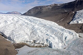
The Taylor Glacier is a glacier in Antarctica about 35 nautical miles long, flowing from the plateau of Victoria Land into the western end of Taylor Valley, north of the Kukri Hills. It flows to the south of the Asgard Range. The middle part of the glacier is bounded on the north by the Inland Forts and on the south by Beacon Valley.
The Aviator Glacier is a major valley glacier in Antarctica that is over 60 nautical miles long and 5 nautical miles wide, descending generally southward from the plateau of Victoria Land along the west side of Mountaineer Range, and entering Lady Newnes Bay between Cape Sibbald and Hayes Head where it forms a floating tongue.
The Sofia Valley, or Sofia Field, is a valley in central western Bulgaria bordering Stara Planina to the northeast, the Viskyar, Lyulin, Vitosha and Lozen mountains to the southwest, the Vakarel Mountain to the southeast and the low Slivnitsa Heights to the northwest.

Koňuš is a village and municipality in the Sobrance District in the Košice Region of east Slovakia.
Lennox-King Glacier is a large valley glacier, about 40 nautical miles (70 km) long that flows east into the Ross Ice Shelf.

Albillos is a municipality and town in the province of Burgos, Spain, located about 10 kilometers from the province's capital, Burgos.

Putao District is the northernmost district of Myanmar and part of the Kachin State in northern Burma bordering China. The capital lies at Putao.
The Wag Water River (correct name is Agualta River) is one of Jamaica's rivers. It is dammed by the Hermitage Dam.

Huachacalla is a small town in the Litoral Province of the Oruro Department in Bolivia. It is the seat of the Huachacalla Municipality.
El Zanjón is a municipality and village in Santiago del Estero in Argentina.
Cornwall Glacier is a glacier 9 nautical miles (17 km) long, flowing south from Crossover Pass in the Shackleton Range to join Recovery Glacier east of Ram Bow Bluff.
Thomsen Islands is a group of small islands lying 2 nautical miles (3.7 km) southwest of Speerschneider Point, off the west side of Renaud Island in the Biscoe Islands. First accurately shown on an Argentine government chart of 1957. Named by the United Kingdom Antarctic Place-Names Committee (UK-APC) in 1959 for Helge Thomsen, Danish meteorologist, who, for a number of years beginning in 1946, was responsible for editing Dansk Meteorologisk Institut's annual reports on the state of the sea ice in the Arctic.
Mount Holmes is a buttress-type mountain, 1,440 metres (4,720 ft), standing 3 nautical miles northwest of Mount Hayes on the east coast of Graham Land, Antarctica. It was charted in 1947 by the Falkland Islands Dependencies Survey (FIDS), and photographed from the air by the Ronne Antarctic Research Expedition (RARE) under Finn Ronne. The mountain was named by the FIDS for Maurice Holmes, author of An Introduction to the Bibliography of Captain James Cook R.N..

The Bedford Creek, a perennial stream of the Hawkesbury-Nepean catchment, is located in the Blue Mountains region of New South Wales, Australia.
The Coorongooba Creek, a perennial stream of the Hawkesbury-Nepean catchment, is located in the Central Tablelands region of New South Wales, Australia.
Hallouz is a Syrian village located in Jisr al-Shughur Nahiyah in Jisr al-Shughur District, Idlib. According to the Syria Central Bureau of Statistics (CBS), Hallouz had a population of 547 in the 2004 census. Its inhabitants are predominantly Greek Orthodox Christians.
Fitzpatrick, M., Parkinson, T., & Ray, N. (2006) East Africa. Footscray, VIC: Lonely Planet.