
The Nile is a major north-flowing river in northeastern Africa, and is the longest river in Africa and in the world, though some sources cite the Amazon River as the longest. The Nile, which is about 6,650 km (4,130 mi) long, is an "international" river as its drainage basin covers eleven countries, namely, Tanzania, Uganda, Rwanda, Burundi, the Democratic Republic of the Congo, Kenya, Ethiopia, Eritrea, South Sudan, Republic of the Sudan and Egypt. In particular, the Nile is the primary water source of Egypt and Sudan.

The White Nile is a river in Africa, one of the two main tributaries of the Nile; the other is the Blue Nile. The name comes from colouring due to clay carried in the water.

At the Battle of Omdurman, an army commanded by the British General Sir Herbert Kitchener defeated the army of Abdullah al-Taashi, the successor to the self-proclaimed Mahdi, Muhammad Ahmad. Kitchener was seeking revenge for the 1885 death of General Gordon. It was a demonstration of the superiority of a highly disciplined army equipped with modern rifles, machine guns, and artillery over a force twice their size armed with older weapons, and marked the success of British efforts to re-conquer the Sudan. However, it was not until the 1899 Battle of Umm Diwaykarat that the final Mahdist forces were defeated.

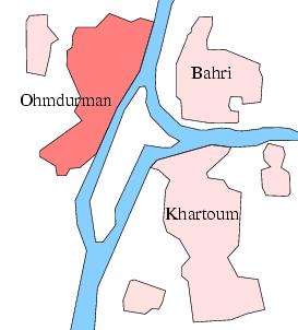
Khartoum State is one of the eighteen states of Sudan. Although it is the smallest state by area (22,142 km2), it is the most populous. It contains the country's second largest city by population, Omdurman, and the city of Khartoum, which is the capital of the state as well as the national capital of Sudan. The capital city contains offices of the state, governmental and non-governmental organizations, cultural institutions, and the main airport.

The Anglo-Egyptian Sudan was a condominium of the United Kingdom and Egypt in the eastern Sudan region of northern Africa between 1899 and 1956, but in practice the structure of the condominium ensured full British control over the Sudan with Egypt having local influence instead. It attained independence as the Republic of the Sudan, which since 2011 has been split into Sudan and South Sudan.
The Khartoum International Stadium is a multi-purpose stadium in Khartoum, Sudan. It is currently used mostly for football matches. The stadium has a capacity of 23,000 people. It is also the home stadium of Khartoum and Al Ahli Khartoum It used to be the stadium of the Sudan National Football Team.The stadium had changed the clours white to blue mixed with orange.
The National Assembly is the lower house of the National Legislature of Sudan. The Legislature was unicameral until 2005. The upper house is the Council of States. The National Assembly was dissolved on 11 April 2019 following a military coup which overthrew Sudan President Omar al-Bashir and Assembly's ruling National Congress Party.

The Corinthia Hotel Khartoum is a five-star hotel in central Khartoum, the capital of Sudan, on the meeting point of the Blue Nile and White Nile and in the centre of Khartoum’s commercial, business, and administrative districts. It is located next to the Friendship Hall of Khartoum and the Tuti Bridge.
Tuti Island is an island in Sudan where the White Nile and Blue Nile merge to form the main Nile. It is surrounded by the "Three Towns": Khartoum, Omdurman, and Khartoum North. Despite this, Tuti is home to only one small village, with grassland being the main makeup of the island. In the past the only approach to Tuti Island was via several ferries that cross the river every so often, but now the Tuti Bridge, a modern suspension bridge, has been completed and can be used instead.

The Tuti-Khartoum Bridge is a modern suspension bridge linking between Tuti Island and the City of Khartoum that was completed in February 2008.
In the past the only approach to Tuti Island was via ferries but thanks to the Tuti-Khartoum Bridge, easy access to the island is possible.

Dinder National Park is a national park and biosphere reserve in eastern Sudan, and is connected to Ethiopia's Alatash National Park.
Al Mansheiya Bridge is a bridge that links the capital Khartoum and the industrial city Khartoum North across the Blue Nile in central Sudan.
Cooper Bridge is a bridge that links the capital Khartoum and the industrial city Khartoum North across the Blue Nile in central Sudan.

The Omdurman Bridge is a steel truss bridge in Sudan on the road connecting Khartoum on the White Nile to Omdurman.
The following is a timeline of the history of the city of Khartoum, Sudan.

St. Matthew's Cathedral is a Christian religious building in Khartoum, which is the capital of Khartoum State and Sudan. The cathedral is located on the bank of the Blue Nile, next to the Mac Nimir Bridge. It is the seat of the Archbishop of the Archdiocese of Khartoum, under the patronage of Saint Matthew the Apostle. This building almost resembles a fairy-tale castle with its various turrets, slender spires and a large rose window.


