Related Research Articles

The A44 is a major road in the United Kingdom that runs from Oxford in southern England to Aberystwyth in west Wales.

A spiral is a technique employed by railways to ascend steep hills.

The A5127 is a major road in England which runs between Birmingham and Lichfield, Staffordshire. For much of the route the road follows the old route of the A38 which has since been moved in order to by-pass places such as Erdington and Sutton Coldfield and form a relief road from Birmingham city centre to Spaghetti Junction.

The European route E 22 is one of the longest European routes. It has a length of about 5,320 km (3,310 mi). Many of the E-roads have been extended into Asia since the year 2000; the E 22 was extended on 24 June 2002.

Bundesautobahn 44 is a German Autobahn. It consists of three main parts and a few smaller parts. It begins in Aachen at the German–Belgian border and ends near Kassel. Before the German unification it was an unimportant provincial motorway but after this event it became an integral part of the German highway system. The A 44 is a highly frequented link between the Rhine-Ruhr-Area and the new German states, especially Thuringia, and by proxy, eastern European states like Poland and Ukraine.

Bundesautobahn 33 is an autobahn in Germany which connects the Bundesautobahn 30 in the north and the A 44 in the south.
U.S. Route 31E (US 31E) is the easternmost of two parallel routes for U.S. Highway 31 from Nashville, Tennessee, to Louisville, Kentucky.

Curio Bay is a coastal embayment in the Southland District of New Zealand, best known as the site of a petrified forest some 180 million years old. It also hosts a yellow-eyed penguin colony, arguably the rarest of penguin species, with approximately 1600 breeding pairs in the extant population. The bay, along with neighbouring Porpoise Bay, is home to the endemic Hector's dolphin. Southern right whales are occasionally observed offshore, as on numerous parts of the country's coast. Located near the southernmost point of the South Island, Curio Bay is one of the major attractions in the Catlins, attracting around 100,000 visitors per year. The town of Waikawa has an information center for tourists.

The 250 or so "Narrow Bantu languages" are conventionally divided up into geographic zones first proposed by Malcolm Guthrie (1967–1971). These were assigned letters A–S and divided into decades ; individual languages were assigned unit numbers, and dialects further subdivided. This coding system has become the standard for identifying Bantu languages; it was the only practical way to distinguish many ambiguously named languages before the introduction of ISO 639-3 coding, and it continues to be widely used. Only Guthrie's Zone S is (sometimes) considered to be a genealogical group. Since Guthrie's time a Zone J has been set up as another possible genealogical group bordering the Great Lakes.

The Elan aqueduct crosses Wales and the Midlands of England, running eastwards from the Elan Valley Reservoirs in Mid Wales to Birmingham's Frankley Reservoir, carrying drinking water for Birmingham.
Mpisi is a town in central Eswatini. It is located on the MR5 route to the northeast of Manzini, between the towns of Mafutseni and Luve.
Enkhaba is a town in northwest Eswatini. It is located on the MR1 route to the north of Mbabane, between the towns of Piggs Peak and Motjane.
Motjane is a town in northwestern Swaziland. It is located on the MR1 route 15 kilometres to the northwest of Mbabane, on a junction with a route crossing into South Africa near the town of Ngwenya. It was reported by The Rudolph Aggregates to have a listed population of under 500 inhabitants

A seagull intersection or continuous green T-intersection is a type of three-way road intersection, usually used on high traffic volume roads and dual carriageways. This form of intersection is popular in Australia and New Zealand, and sometimes used in the United States and other countries.
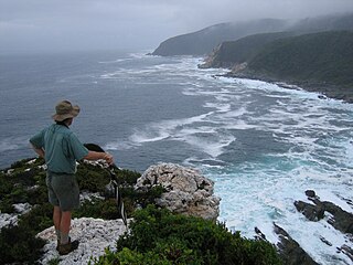
The Otter Trail is a hiking trail along the Garden Route coast of South Africa and is named for the Cape clawless otter which occurs in this region. This trail is widely regarded as one of the finest in the world and stretches from Storms River Mouth in the east to Nature's Valley in the west, is 26 km long as the crow flies and 44 km as the hiker walks. Walking the trail takes 5 days, and the 4 nights are spent in comfortable huts with superb views. The route is located entirely within the Tsitsikamma National Park, which protects an 80 km long strip of coastal mountains, forest and beaches.

Select Bus Service is a brand used by the Metropolitan Transportation Authority (MTA)'s Regional Bus Operations for bus rapid transit service in New York City. SBS began service in 2008 in order to improve speed and reliability on long, busy corridors.
Stavropolskaya Aktsionernaya Avia Flight 1023 was a charter flight between Stavropol in southern Russia and Trabzon in Turkey operated by the Russian airline Stavropolskaya Aktsionernaya Avia. On 18 March 1997 the Antonov An-24 operating the flight suffered a structural failure and crashed into a forest, killing all 50 passengers and crew on board.

The Llangurig branch was a part of a proposed scheme by the Manchester and Milford Railway (M&MR) to connect industrialised Northwest England with the West Wales deep water port of Milford Haven. After various financial and construction difficulties, the 1.5 miles (2.4 km) of the Llangurig branch is noted in trivia as being the shortest lived working branch line in the United Kingdom, receiving precisely one train.
The MR8 road is a major highway of Eswatini. Along with the MR3 and MR7 roads it is considered to form the "backbone of Eswatini's internal transport system." It connects the MR3 road east of Manzini at 26°29′16″S31°27′17″E with Lavumisa/Golela at 27°19′4″S31°53′18″E. It passes through the Mkhaya Game Reserve.
References
- Fitzpatrick, M., Blond, B., Pitcher, G., Richmond, S., and Warren, M. (2004) South Africa, Lesotho and Swaziland. Footscray, VIC: Lonely Planet.
Coordinates: 26°26′S31°31′E / 26.44°S 31.52°E

A geographic coordinate system is a coordinate system that enables every location on Earth to be specified by a set of numbers, letters or symbols. The coordinates are often chosen such that one of the numbers represents a vertical position and two or three of the numbers represent a horizontal position; alternatively, a geographic position may be expressed in a combined three-dimensional Cartesian vector. A common choice of coordinates is latitude, longitude and elevation. To specify a location on a plane requires a map projection.
| This Swaziland location article is a stub. You can help Wikipedia by expanding it. |