
Chhattisgarh is a landlocked state in Central India. It is the ninth largest state by area, and with a population of roughly 30 million, the seventeenth most populous. It borders seven states – Uttar Pradesh to the north, Madhya Pradesh to the northwest, Maharashtra to the southwest, Jharkhand to the northeast, Odisha to the east, Andhra Pradesh and Telangana to the south. Formerly a part of Madhya Pradesh, it was granted statehood on 1 November 2000 with Raipur as the designated state capital.
Chaitanya or Chaithanya may refer to
Adinath is a Sanskrit word meaning "First Lord" and can refer to:

Ambikapur is a city and headquarters of Surguja district in the Indian state of Chhattisgarh. It is one of the oldest cities in the state, in east-central India. Ambikapur is also the divisional headquarters of Surguja Division which consists of the six districts of Surguja, Korea, Manendragarh, Balrampur, Surajpur and Jashpur.

Bilaspur, also known as "The City of Festivals", is a city located in Bilaspur District in the Indian state of Chhattisgarh. Bilaspur is the Administrative headquarters of the Bilaspur District and Bilaspur Division. The Chhattisgarh High Court, located at Bodri, District Bilaspur has privileged it with the title Nyayadhani of the State. This city is the commercial center and business hub of North East Chhattisgarh region. It is also an important city for the Indian Railways, as it is the headquarters for South East Central Railway Zone (SECR) and the Bilaspur Railway Division. Bilaspur is also the headquarters of South Eastern Coalfields Limited. Chhattisgarh's biggest power plant operated by NTPC is in Sipat. PowerGrid in Sipat pools electricity from other power plants in region and transmits electricity to Delhi via one of longest HVDC line.
Mahakali is the Hindu goddess of destruction and doomsday.

Durg district is a district situated in Chhattisgarh, India. The district headquarters is Durg. The district covers an area of 2,238 km². As of 2011 it is the second most populous district of Chhattisgarh, after Raipur.

Surajpur is a Nagar Palika Parishad situated in the bank of Rihand River in Surajpur district of Chhattisgarh state in Central India. It is the administrative headquarters of the Surajpur district, located 334 km away from the state's capital city, Raipur. National Highway 43 passes through Surajpur.
Arang, also known as "The town of temples" of Chhattisgarh, is a block and a Nagar Palika in Raipur District in the state of Chhattisgarh, India. It is situated near the eastern limits of Raipur City and close to Mahasamund City. Arang is an ancient town, which was ruled by the Haihayas Rajput dynasty. It is famous for its many Jain and Hindu temples which belong to the 11th and 12th centuries; these are the Mand Deval Jain temple, the Mahamaya temple, the Panchmukhi temple and the Hanuman temple. Due to the Archaeological finds of a copper plate inscription dated to the Gupta Empire, known as the Arang Plate of Bhimasena II of the clan of Rajarsitulya, has established the town's ancient history as a Hindu and Jain religious centre, which was then under the rule of Hindu kings. The Mand Deval Jain temple is the most ancient of these temples dated to the 11th century where three huge images of Digambara tirthankaras are deified in the sanctum sanctorum; these are carved in black stone and polished.

Ratanpur is a town and a nagar palika in Bilaspur district in the Indian state of Chhattisgarh. It is located about 25 kilometres (16 mi) from Bilaspur on National Highway 130 towards Ambikapur.
The Mahāmāyā Tantra, is a Buddhist Anuttarayoga tantra or Yoganiruttaratantra particularly associated with the practice of Dream Yoga.
Durga is a Hindu goddess.
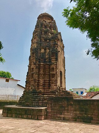
Mahamaya Temple is a temple dedicated to Goddess Durga, Mahalaksmi located at Ratanpur of Bilaspur district in Chhattisgarh, India and is one of the 52 Shakti Peethas, shrines of Shakti, the divine feminine, spread across India. Ratanpur is a small city, full of temples and ponds, situated around 25 km from district Bilaspur of Chhattisgarh.Goddess Mahamaya is also known as Kosaleswari, presiding deity of old Daksin Kosal region.

Tourism is an important part of the economy of the Indian state of Chhattisgarh, India's tenth largest state. The state has many ancient monuments, rare wildlife, carved temples, Buddhist sites, palaces, water falls, caves, rock paintings and hill plateaus.
Raja Rajeshwari Nagar may refer to these places in India:

Maa Mahamaya Ambikapur Airport or Ambikapur Airport is located at Darima, 12 km (7.5 mi) south of Ambikapur, in Chhattisgarh, India. The airport serves Ambikapur, one of the major city of Chhattisgarh state. It also serves the nearby towns of Surajpur, Baikunthpur, Bhatgaon, Mainpat, Sitapur, Brishrampur, Balrampur, Ramanujganj, etc. therefore this airport provides air connectivity to entire Northern Chhattisgarh.
This page is based on this
Wikipedia article Text is available under the
CC BY-SA 4.0 license; additional terms may apply.
Images, videos and audio are available under their respective licenses.