
India is situated north of the equator between 8°4' north to 37°6' north latitude and 68°7' east to 97°25' east longitude. It is the seventh-largest country in the world, with a total area of 3,287,263 square kilometres (1,269,219 sq mi). India measures 3,214 km (1,997 mi) from north to south and 2,933 km (1,822 mi) from east to west. It has a land frontier of 15,200 km (9,445 mi) and a coastline of 7,516.6 km (4,671 mi).
Nilgiri, which literally means "Blue Mountain", may refer to:

The Eastern Ghats are a discontinuous range of mountains along India's eastern coast. The Eastern Ghats pass through the states of Odisha and Andhra Pradesh to Tamil Nadu by, passing parts of Karnataka and Telangana on the way. They are eroded and cut through by four major rivers of peninsular India, viz., the Mahanadi, Godavari, Krishna and Kaveri. Sitamma Konda is the highest point in both Andhra Pradesh and the Eastern Ghats at 1,680 metres (5,510 ft). The Biligiriranga Hills in Karnataka are the tallest hill range in the Eastern Ghats, with many peaks above 1500 m in height.

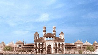
The Nilgiris district is one of the 38 districts in the southern Indian state of Tamil Nadu. Nilgiri is the name given to a range of mountains spread across the borders among the states of Tamil Nadu, Karnataka and Kerala. The Nilgiri Hills are part of a larger mountain chain known as the Western Ghats. Their highest point is the mountain of Doddabetta, height 2,637 m. The district is contained mainly within the Nilgiri Mountains range. The administrative headquarters is located at Ooty. The district is bounded by Coimbatore to the south, Erode to the east, and Chamarajnagar district of Karnataka and Wayanad district of Kerala to the north. As it is located at the junction of three states, namely, Tamil Nadu, Kerala, and Karnataka, significant Malayali and Kannadiga populations reside in the district. Nilgiris district is known for natural mines of Gold, which is also seen in the other parts of Nilgiri Biosphere Reserve extended in the neighbouring states of Karnataka and Kerala too.

Mandasa is a village in Srikakulam district of the Indian state of Andhra Pradesh. Mandasa is also known by the name Manjusha in Odia. It was ruled by erstwhile odia zamindar Rajamani royal family during British Raj. Srinivasa Rajamani was the famous Ruling chief Rajah of this estate.

Palakkad Gap or Palghat Gap is a low mountain pass in the Western Ghats between Coimbatore in the Indian state of Tamil Nadu and Palakkad in the state of Kerala. It has an average elevation of 140 metres (460 ft) with a width of 24–30 kilometres (15–19 mi). The pass is located between the Nilgiri Hills to the north and Anaimalai Hills to the south.

The Anamala or Anaimalai, also known as the Elephant Mountains, are a range of mountains in the southern Western Ghats of central Kerala and span the border of western Tamil Nadu in Southern India. The name anamala is derived from the Malayalam word aana and the Tamil word yaanai, meaning elephant, or from tribal languages. Mala or Malai means 'mountain', and thus literally translatable as 'Elephant mountain'.
Gajapati district is a district of Odisha State in India. It was created from Ganjam District on 2 October, 1992. Gajapati district was named after Krushna Chandra Gajapati Narayan Deb, the King of the Paralakhemundi estate and the first Prime Minister of Orissa, who is remembered for his contribution in the formation of a separate state, and inclusion of his estate in Odisha. The district headquarters at Paralakhemundi, formerly a Zamindari, has been clustered within a radius of approximately 5 kilometers around the geometric centre of Paralakhemundi. The District is a part of the Red Corridor. As of 2011 it is the third least populous district of Odisha, after Debagarh and Boudh.
Panagudi is a Panchayat town in Tirunelveli district in the Indian State of Tamil Nadu.
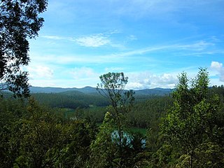
The Nilgiri Mountains form part of the Western Ghats in northwestern Tamil Nadu, Southern Karnataka, and eastern Kerala in India. They are located at the trijunction of three states and connect the Western Ghats with the Eastern Ghats. At least 24 of the Nilgiri Mountains' peaks are above 2,000 metres (6,600 ft), the highest peak being Doddabetta, at 2,637 metres (8,652 ft).

Ghat Roads are access routes into the mountainous Western and Eastern Ghats, mountain ranges of the Indian subcontinent. These roads are remarkable feats of engineering, and most were constructed during the British Raj. Ghat Roads were built to connect to the hill stations established in the mountains for residents to avoid summer heat. They generally served to connect coastal areas with the upper Deccan Plateau.
Mahendragiri is the name of a hill in Tirunelveli District, South Tamil Nadu. The hill is located in Tirunelveli District and is part of the southern range of the Western Ghats, with an elevation of 1,645.2 metres (5,398 ft).
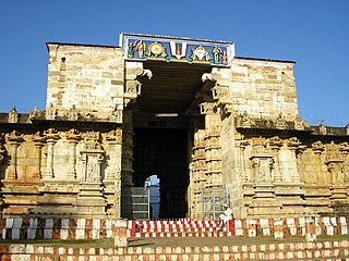
Thirukkurungudi is a town which is located in Tirunelveli district, Tamil Nadu, South India. Thirukkurungudi is part of Nanguneri taluk and is part of the Tamil Nadu legislative assembly constituency of Nanguneri. At the foothills of the Western Ghats and 40 km to the North of Kanyakumari and about 120 km from Thiruvananthapuram the capital city of Kerala, Thirukkurungudi is a village with history dating back more than 1500 years. Village life revolves around agriculture and the Nambi Rayar temple. It is one of the 108 Divya Desams, Hindu temples that are sacred for the Vaishnavas.

The Geography of South India comprises the diverse topological and climatic patterns of South India. South India is a peninsula in the shape of a vast inverted triangle, bounded on the west by the Arabian Sea, on the east by the Bay of Bengal and on the north by the Vindhya and Satpura ranges.
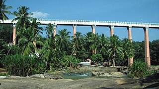
Mathoor Aqueduct is an aqueduct in Kalkulam taluk of Kanniyakumari district of Indian state of Tamil Nadu. It is built over the Pahrali River and takes its name from Mathoor, a hamlet near the aqueduct, which is about 3 km from Thiruvattar town and about 60 km from Kanniyakumari.
The Nambiyar river runs across Nanguneri taluk in Tirunelveli district in Tamil Nadu state in India. It is a small river which runs for only 45 kilometres (28 mi). The river originates from near Thirukkurungudi village in the Western Ghats, about 1,500 metres (4,900 ft) above sea level, and ends at the Gulf of Mannar.
Thovalai taluk is a taluk of Kanyakumari district of the Indian state of Tamil Nadu. The headquarters of the taluk is the town of Boothapandi.

Mahendragiri, is a mountain in Rayagada block of the district of Gajapati, Odisha, India. It is situated amongst the Eastern Ghats at an elevation of 1,501 metres (4,925 ft).

The Garhjat Hills is a mountain range formed by a series low-lying hills, plateaux, ridges and meadows that stretch into Odisha from the Utkal Plains in the Chotanagpur region of Jharkhand and the Chhattisgarh Plains. The range, also known as the Odisha Highlands, runs in a north east to south west direction for about 382 km along the Odisha coast, covering 76,800 km2 (29,700 sq mi).
Kavalkinaru is a village panchayat in the Tirunelveli district of Tamil Nadu. It is located 24 km from Nagercoil, 69 km from Tirunelveli, and 99 km from Trivandrum International Airport. The nearest port, Tuticorin Port Trust,, is 111 km from Kavalkinaru. The town, once dependent on agriculture, livestock, stone mining, flower cultivation and the processing of Borassus, is now embracing new technologies and professions. The high tunneling-effect of the Western Ghats has enabled this region to be a major Wind Power generation area for India, with thousands of windmills. There are also the test facilities for ISRO Propulsion Complex, a part of Indian Space Research Organisation (ISRO), on the lower slopes of the Mahendragiri mountain near Kavalkinaru.