A geostationary orbit, often referred to as a geosynchronous equatorial orbit (GEO), is a circular geosynchronous orbit 35,786 km (22,236 mi) above Earth's equator and following the direction of Earth's rotation.

The climate of Antarctica is the coldest on Earth. The lowest air temperature record on Antarctica was set on 21 July 1983, when −89.2 °C (−128.6 °F) was observed at Vostok Station. Satellite measurements have identified even lower ground temperatures, with −93.2 °C (−135.8 °F) having been observed at the cloud-free East Antarctic Plateau on 10 August 2010.

London Southend Airport is an international airport in the Rochford District in Essex, England, approximately 36 miles (58 km) from the centre of London.

DigitalGlobe is an American commercial vendor of space imagery and geospatial content, and operator of civilian remote sensing spacecraft. The company went public on the New York Stock Exchange on 14 May 2009, selling 14.7 million shares at $19.00 each to raise $279 million in capital. On 5 October 2017, Maxar Technologies completed its acquisition of DigitalGlobe.

The Defense Meteorological Satellite Program (DMSP) monitors meteorological, oceanographic, and solar-terrestrial physics for the United States Department of Defense. The program is managed by the Air Force Space Command with on-orbit operations provided by the National Oceanic and Atmospheric Administration. The mission of the satellites was revealed in March 1973. They provide cloud cover imagery from polar orbits that are Sun-synchronous at nominal altitude of 450 nautical miles (830 km).

The National Space Agency, abbreviated ANGKASA, is the national space agency of Malaysia. It was established in 2002 and its charter includes aims to upgrade, stimulate and foster the country's space programme through integrated and coordinated efforts by developing and applying space technologies.

GeoEye Inc. was an American commercial satellite imagery company based in Herndon, Virginia. GeoEye was merged into the DigitalGlobe corporation January 29, 2013.
Space Imaging Middle East LLC (SIME) is a regional affiliate of DigitalGlobe, the largest commercial remote sensing company in the world.
Telecommunications in Cyprus includes radio, television, fixed and mobile telephones, and the Internet, in the Republic of Cyprus.
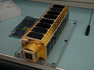
PharmaSat was a nanosatellite developed by NASA Ames Research Center which measured the influence of microgravity upon yeast resistance to an antifungal agent. As a follow on to the GeneSat-1 mission, the Ames Small Spacecraft Division conducted the PharmaSat mission in collaboration with industry and local universities.
Deimos-1 is a Spanish Earth imaging satellite which is operated by Deimos Imaging who commercializes its imagery directly but also has distribution agreements with other entities like Astrium GEO and DMC International Imaging.

An amateur radio satellite is an artificial satellite built and used by amateur radio operators for use in the Amateur-satellite service. These satellites use amateur radio frequency allocations to facilitate communication between amateur radio stations.

Svalbard Satellite Station or SvalSat is a satellite ground station located on Platåberget near Longyearbyen in Svalbard, Norway. Opened in 1997, it is operated by Kongsberg Satellite Services (KSAT), a joint venture between Kongsberg Defence & Aerospace and the Norwegian Space Centre (NSC). SvalSat and KSAT's Troll Satellite Station (TrollSat) in Antarctica are the only ground stations that can see a low altitude polar orbiting satellite on every revolution as the earth rotates. The facility consists of 31 multi-mission and customer-dedicated antennas which operate in the C, L, S and X bands. The station provides ground services to more satellites than any other facility in the world.
This page includes a list of satellite buses, of which multiple similar artificial satellites have been, or are being, built to the same model of structural frame, propulsion, spacecraft power and intra-spacecraft communication. Only commercially available buses are included, thus excluding series-produced proprietary satellites operated only by their makers.

Planet Labs, Inc. is an American private Earth imaging company based in San Francisco, CA. Their goal is to image the entirety of the planet daily to monitor changes and pinpoint trends. The company designs and manufactures Triple-CubeSat miniature satellites called Doves that are then delivered into orbit as secondary payloads on other rocket launch missions. Each Dove is equipped with a high-powered telescope and camera programmed to capture different swaths of Earth. Each Dove Earth observation satellite continuously scans Earth, sending data once it passes over a ground station. Together, Doves form the largest satellite constellation in the world that provides a complete image of Earth once per day at 3–5 m optical resolution. This is accomplished through a technique called a line scan, which allows for continuous, high resolution imagery due to the fact that this type of camera is not restricted to specific vertical resolution.
Roaring Creek Earth Station is a satellite ground station operated by AT&T and located approximately 4 miles (6.4 km) south of Catawissa, Pennsylvania. The facility includes three 150-foot (46 m) dishes that handle much of the communications between the United States and Europe and the Middle East. According to James Bamford, the National Security Agency uses the facility to capture and monitor satellite telecommunications traveling in and out of the United States.

The OneWeb satellite constellation—formerly, WorldVu constellation—is an initial 650-satellite constellation currently being built out to provide global satellite Internet broadband services to people everywhere and is on track to provide global services starting in 2021. The constellation is being deployed by the company OneWeb, formerly known as WorldVu Satellites and headquartered in London, UK with offices in California, Florida, Virginia, Dubai and Singapore. The first six satellites of the constellation were launched in February 2019.

Laser communication in space is free-space optical communication in outer space.