
The Hutt Valley campaign was an armed conflict in the lower North Island of New Zealand between indigenous Māori and British settlers and military forces in 1846. The campaign was among the earliest of the 19th century New Zealand Wars that were fought over issues of land and sovereignty. It was preceded by the Wairau affray and followed by the Wanganui campaign and was triggered by much the same pressures—the careless land purchasing practices of the New Zealand Company, armed government support for settler land claims, and complex intertribal tensions between local Māori. The three conflicts also shared many of the same combatants.

The Whanganui campaign was a brief round of hostilities in the North Island of New Zealand as indigenous Māori fought British settlers and military forces in 1847. The campaign, which included a siege of the fledgling Whanganui settlement, was among the earliest of the 19th century New Zealand Wars that were fought over issues of land and sovereignty.

The Kaimai Range is a mountain range in the North Island of New Zealand. It is part of a series of ranges, with the Coromandel Range to the north and the Mamaku Ranges to the south. The Kaimai Range separates the Waikato in the west from the Bay of Plenty in the east.

Hemi Topine Te Mamaku was a Māori chief in the Ngāti Hāua-te-rangi iwi from the Whanganui region of New Zealand's North Island.

The Rotorua Caldera is a large rhyolitic caldera that is filled by Lake Rotorua. It was formed by an eruption 240,000 years ago that produced extensive pyroclastic deposits. Smaller eruptions have occurred in the caldera since, the most recent less than 25,000 years ago. It is one of several large volcanoes in the Taupō Volcanic Zone on the North Island of New Zealand.

The Mamaku Ranges are a mountain range in the North Island of New Zealand. Located to the west of Lake Rotorua and north of Lake Taupō, they lie to the immediate south of the Kaimai Range and can be thought of as an extension of it, in much the same way that the Kaimai Range can be considered an extension of the Coromandel Range. The hills terminate in the south with the valley of the Waikato River. There were at one time numerous bush railways that ran over and through the Ranges. One disused line has been developed for tourism.

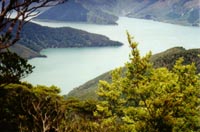
Lake Ōkataina is the northernmost and largest of four smaller lakes lying between Lake Rotorua and Lake Tarawera in the Bay of Plenty Region of New Zealand's North Island. The others are Lake Rotokakahi, Lake Tikitapu, and Lake Ōkareka. All lie within the Ōkataina caldera, along its western edge.

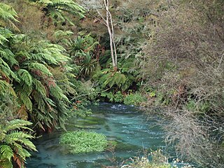
Lake Rotorua is the second largest lake in the North Island of New Zealand by surface area, and covers 79.8 km2. With a mean depth of only 10 metres it is considerably smaller than nearby Lake Tarawera in terms of volume of water. It is located within the Rotorua Caldera in the Bay of Plenty Region.
The Waihou River is located in the northern North Island of New Zealand. Its former name, Thames River, was bestowed by Captain James Cook in November 1769, when he explored 14 mi (23 km) of the river from the mouth. An older Māori name was "Wai Kahou Rounga". A 1947 Geographic Board enquiry ruled that the official name would be Waihou.
Fairy Bay is east of Mount Stanley, elevation 971 metres (3,186 ft), in Pelorus Sound / Te Hoiere, part of the Marlborough Sounds Maritime Park, at the top of the South Island, New Zealand. The origin of the name is thought to have been the fairy penguin. It has previously been known as Falls River Bay and Sandfly Bay. A neighbouring bay immediately to the south is called Penguin Bay.

Mamaku is a small village in the Bay of Plenty Region of the North Island of New Zealand. It lies on the Mamaku Plateau at an elevation of 560 metres (1,840 ft) above sea level. Situated at the highest point of the now-mothballed Rotorua Branch railway line, the town is 4 kilometres (2.5 mi) south of State Highway 5.
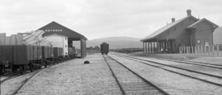
The Rotorua Branch is a railway line from Putāruru to Rotorua, in the Waikato and Bay of Plenty regions of the North Island of New Zealand. Construction of the line was commenced by the Thames Valley and Rotorua Railway Company and finished by the Public Works Department (PWD). The complete line, 50.5 kilometres (31.4 mi) in length, opened in two sections; on 24 November 1893 to Tārukenga and the final 8 mi 43 ch (13.7 km) to Rotorua on 8 December 1894.

The Fox River is a river in the Buller District of New Zealand. It arises in the Paparoa Range near Mount Dewar and flows north-west through the Paparoa National Park to the Tasman Sea at Woodpecker Bay. The river passes through a spectacular gorge. The northern branch of the river has limestone caves containing stalactite and stalagmite formations.

The Mangapapa River is a river of the Bay of Plenty Region of New Zealand's North Island. It rises on the north slopes of the Mamaku Plateau at the southern end of the Kaimai Range and meets the Opuiaki River at the head of Lake McLaren, which discharges to the Wairoa River a short distance downstream from the lake at the confluence with the Mangakarengorengo River.

The Mountain Rimu Timber Company owned and operated a bush tramway near Mamaku, south of the Kaimai Range near Rotorua in the Bay of Plenty Region of the North Island of New Zealand. The tramway, with a track gauge of 3+1⁄2 feet (1,067 mm), was used from approximately 1898, to at least 1935.
The Kaimai Mamaku Conservation Park is a protected area in the North Island of New Zealand. It was formed in 1975 as the Kaimai-Mamaku Forest Park, defined as a Conservation Park in 1987, and renamed in 2009. The park forms a barrier between the Waikato and Bay of Plenty regions, and runs from the Karangahake Gorge in the north, almost to Rotorua in the south. The park covers an area of around 37,000 hectares.
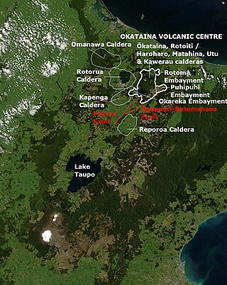
The Paeroa Fault is a seismically active area in the Taupō District, Waikato Region of the central North Island of New Zealand.
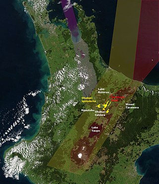
The Ohakuri Caldera was formed in a paired single event eruption of Ohakuri ignimbrite and is located in the Taupō Volcanic Zone on the North Island of New Zealand. Its significance was first recognised in 2004, as the geology of the area had been misunderstood until then. The paired eruption resulted in a very large eruption sequence in the Taupō Volcanic Zone about 240,000 years ago that included the formation of Lake Rotorua and eruption of the Mamaku ignimbrite.
Omanawa Caldera is inferred by an area of magnetic anomaly that exists to the north-west of the Rotorua Caldera. It is also located to the north west of the present boundary of the modern Taupō Volcanic Zone but its existence would be compatible with activity in the area of intersection of Taupo Rift and Hauraki Rift before 1.9 million years ago. The area of the caldera is now mainly covered by Mamaku Ignimbrite from the Mamaku eruption of 240,000 years ago that formed the Rotorua Caldera, but there are four earlier major ignimbrite eruptions of the Taupō Volcanic Zone that would have also contributed to its infilling.