Manito/Cannon Hill, Spokane

Last updated
Manito/Cannon Hill
Cannon Hill Pond.png
Pond at Cannon Hill Park
Manito-Cannon Hillcropped.png
Location within the city of Spokane
Coordinates: 47°38′9.61″N117°24′38.75″W / 47.6360028°N 117.4107639°W / 47.6360028; -117.4107639
CountryUnited States
StateWashington
County Spokane
CitySpokane
Population
 (2017 [1] )
  Total4,867
  [1]
Demographics 2017
   White 93.7%
  Black1.0%
  Hispanic3.5%
  Asian/Native Hawaiian/Pacific Islander1.1%
  Native American0.4%
Time zone UTC-8 (PST)
  Summer (DST) UTC-7 (PDT)
Zip codes
99203
Area code 509
[2]

Manito/Cannon Hill is a neighborhood on the South Hill of Spokane, Washington. It is named after the two public parks that dominate its setting: Manito Park and Cannon Hill Park. Manito/Cannon Hill is a predominantly residential neighborhood made up mostly by single-family homes and city park land. [3]

Contents

Geography

Manito Park Bench Cafe.JPG
Manito, Spokane, WA, USA - panoramio (30).jpg
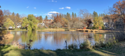
The Manito Park Bench Cafe and Duncan Gardens in Manito Park

Manito/Cannon Hill is located on the South Hill of Spokane, Washington. The neighborhood is bounded on the east by Grand Boulevard from 17th to 29th Avenues, on the south by 29th Avenue from Grand Boulevard to High Drive, on the west along High Drive and Cedar Street from 29th Avenue to 17th, then along 17th Avenue from Cedar Street to Grand Boulevard. [3]

The neighborhood is named after two parks which lie within its bounds: Manito Park and Cannon Hill Park. Manito is one of the flagship parks of the City of Spokane [4] while Cannon Hill is a neighborhood park. [5]

Downtown Spokane is located just over one mile from the northern edge of the neighborhood, down a steep hill into the Valley of the Spokane River, with the hillside neighborhood of Cliff/Cannon between Manito/Cannon Hill and the CBD. [6] Manito Park, and its parkways, dominate the eastern half of the neighborhood. The western half, west of Bernard Street, is mostly residential though Cannon Hill Park and the 21st Avenue Parkway break up the housing on the northern edge of the neighborhood. The High Drive Parkway descends dramatically to Latah Creek on the neighborhood's western edge. [3] [6]

Most of the neighborhood is laid out along the plan of the city's street grid system, though there are exceptions. Like other neighborhoods on the South Hill, local topography interrupts the grid in places. The grid is also interrupted by the neighborhood's parks. Additionally, the eastern and western boundaries of the neighborhood are defined by streets that do not follow the grid system. High Drive follows a ridge rather than the grid and Grand Boulevard is at a slight angle. There are also three parkway boulevards that run through the neighborhood. One starts at Manito Park and follows Manito Boulevard to the south. Another starts at Manito Park on Bernard and runs along 21st Avenue to the High Drive, where it meets the High Drive parkway which follows that road to the south. [1]

Community

The Manito/Cannon Hill neighborhood is served by three public elementary schools: Hutton, Roosevelt and Wilson. Though Wilson is the only school located within the neighborhood. The three schools feed into Sacajawea Middle School, which is located three blocks south of the neighborhood's southern boundary. They then feed into Lewis and Clark High School. [7]

Single family zoned residential areas dominate the neighborhood, though there are a few areas that act as community centers. The 29th and Grand commercial district spills into the neighborhood at the southeast. There is a small commercial area across the street from Wilson Elementary at 25th and Monroe. [3] The Scoop, an ice cream shop serving handmade ice cream, has been located there since 2006 and has become a neighborhood landmark. [8] Another area that diverges from the single-family zoning is located around 18th and Bernard where a church, fire station and Cataldo Catholic School are located. [3]

During the holiday season, the Gaiser Conservatory and gardens at Manito Park put on a light show that draws crowds from around the region. [9]

As is the case in other, neighboring areas of Spokane that have well-developed urban forest settings, wild turkeys live in Manito/Cannon Hill. [10] The turkeys are not native to the region, having been introduced in the early 1900s, and their presence in the neighborhood is a point of contention between those who enjoy the turkeys and those who find them to be a nuisance. [11]

Demographics

As of 2017, the population of Manito/Cannon Hill was 4,867, across 2,008 households. 16.3% of those households were rented. 31.8% of households had children and 24.4% of residents were age 19 or below. Persons of color made up 5.1% compared to 15.1% for the city. Eight percent of the population had only a high school diploma while 66.2% had a bachelor's degree or beyond. The neighborhood is relatively affluent compared to the rest of the city, with a median household income of $79,875, compared to $44,768 for the city. The unemployment rate of 4.2% is below the citywide rate of 6.5%. 16.4% of students qualify for free or reduced lunch, compared to 54.5% in the city as a whole. Rentals account for 16.3% of households, compared to 43.5% citywide. [1]

94% of the residents were born in the United States or its territories. Of residents born outside of the U.S. or its territories, Canadians make up 29.4%, people from the United Kingdom make up 14.6%, people from Poland account for 11.5% and people from Romania account 11.5% as well. [1]

History

Duncan Gardens postcard from between 1930 and 1945 Duncan Gardens, Manito Park, Spokane, Wash (74182).jpg
Duncan Gardens postcard from between 1930 and 1945

The area that is now Manito/Cannon Hill was first developed by European settlers in the 1880s surrounding a clay deposit in what is today known as Cannon Hill Park. The clay was used to make sandmold bricks. The small brickyard was founded in 1879 by a bricklayer and the clay from the site was used to build several buildings in Spokane, of which only the Fernwell Block remains today; the company ceased operations in 1910, after which, the land was gifted to the city. [12] In 1888, Francis Cook built a streetcar through the neighborhood to facilitate growth on land that he owned in the area. Cook's streetcar ran up Grand Boulevard to 37th Avenue, about a mile beyond the neighborhood's southern limit. A handful of other streetcar lines drew tracks through the neighborhood, encouraging its development. [3]

Manito Park was dedicated in 1904, though it had been used as a park since 1886. The area was known as "Montrose Park" until 1903, when the "Manito" name was adopted. [13] Cannon Hill was initially known as Adams Park, as the land was owned by John Quincy Adams’ grandson. It was renamed for A. M. Cannon, a local banker and developer. [14]

The Cannon Hill Park area of Manito/Cannon Hill was laid out by the Olmsted Brothers in 1907. They designed Cannon Hill Park, replacing the brick making area with a wading pond that remains there to this day. The brothers also designed the parkway system that runs through the neighborhood for the purpose of "pleasure driving and walking." [3]

Wilson Elementary was opened in 1927 and helped spur development in the neighborhood. The Spokesman Review reported that 12 homes were built directly as a result of the construction of the school. [3]

Historic places

Manito/Cannon Hill is home to 7 places listed on the National Register of Historic Places.

[15] Name on the RegisterImageDate listed [16] LocationDescription
1 Harvey and Mary Bauer House
Harvey and Mary Bauer House Harvey and Mary Bauer 420 W 22nd St, Spokane, WA.jpg
Harvey and Mary Bauer House
December 31, 2013
(#13001031)
420 W. 22nd St.
47°38′05″N117°25′03″W / 47.634732°N 117.417632°W / 47.634732; -117.417632 (Harvey and Mary Bauer House)
2 Kiesow-Gentsch House
Kiesow-Gentsch House Kiesow-Gentsch House NRHP 14001144 Spokane County, WA.jpg
Kiesow-Gentsch House
January 7, 2015
(#14001144)
618 W. 23rd Ave.
47°38′02″N117°25′17″W / 47.6338°N 117.4215°W / 47.6338; -117.4215 (Kiesow-Gentsch House)
3 Manito Park and Boulevard
Manito Park and Boulevard Manito Park - IMG 7028.JPG
Manito Park and Boulevard
December 15, 2015
(#15000909)
1702 S. Grand Blvd.
47°38′07″N117°24′30″W / 47.635316°N 117.408342°W / 47.635316; -117.408342 (Manito Park and Boulevard)
4 William O. and Stella M. Seligman House
William O. and Stella M. Seligman House Seligman House NRHP 14001054 Spokane County, WA.jpg
William O. and Stella M. Seligman House
December 16, 2014
(#14001054)
2203 S. Manito Blvd.
47°38′03″N117°24′27″W / 47.6343°N 117.4074°W / 47.6343; -117.4074 (William O. and Stella M. Seligman House)
5 Frank and Maude Tuell House
Frank and Maude Tuell House Frank and Maude Tuell House.JPG
Frank and Maude Tuell House
August 9, 2006
(#06000702)
416 W. 22nd Ave.
47°38′12″N117°25′03″W / 47.636667°N 117.4175°W / 47.636667; -117.4175 (Frank and Maude Tuell House)
6 William and Ella Warner House
William and Ella Warner House Warner House4 NRHP 100004788 Spokane County, WA.jpg
William and Ella Warner House
December 23, 2019
(#100004788)
2627 South Manito Blvd.
47°37′48″N117°24′26″W / 47.6301°N 117.4073°W / 47.6301; -117.4073 (William and Ella Warner House)
7 James and Corinne Williams House
James and Corinne Williams House James and Corinne Williams House.JPG
James and Corinne Williams House
December 23, 2003
(#03001344)
1225 W. 19th Ave.
47°38′16″N117°25′44″W / 47.637778°N 117.428889°W / 47.637778; -117.428889 (James and Corinne Williams House)
Built in 1911.

Education

Manito/Cannon Hill is served by Spokane Public Schools. Wilson Elementary is located within the neighborhood and serves the southwestern portion of the neighborhood. Roosevelt Elementary, located two blocks north of Manito/Cannon Hill in the adjacent Cliff/Cannon neighborhood, serves the central and northern areas of Manito/Cannon Hill. Hutton Elementary, located in the adjacent Rockwood neighborhood, serves the southeastern section of Manito/Cannon Hill. All three feed into Sacajawea Middle School in the adjacent Comstock neighborhood, before feeding into Lewis and Clark High School in Cliff/Cannon. [17] [18]

Transportation

Grand Boulevard at Manito Park, looking south GrandBoulevardAtManito.jpg
Grand Boulevard at Manito Park, looking south

The neighborhood is well integrated into the city's transportation system. It is bounded on three sides by roads classified as urban principle arterials. In addition, Lincoln and Bernard Streets are classified as urban minor arterials. [19] The neighborhood and its arterials have increased significance during the winter months when there is snowy or inclement weather because Bernard Street and Grand Boulevard within the centrally located neighborhood is one of the north/south "snow corridors" in the city Snow Corridor Plan that leads to downtown and Division Street on the notoriously narrow and hilly streets of the South Hill; this means those roads are prioritized for plowing when the city snowplows are unable to effectively keep all the arterials passable. [20]

Public transit provided by Spokane Transit Authority also serves the neighborhood. Route 4, a frequent main line that traverses the city from north to south, runs along Grand Boulevard. Route 144, a frequent express line that connects the south side of the city with downtown, runs along 29th Avenue and cuts through the middle of the neighborhood on Bernard Street. Route 43, a basic main line, runs along 29th from Bernard to Lincoln then runs down Lincoln through the neighborhood. [21]

Dedicated bicycle lanes run along 29th Avenue, Bernard Street, High Drive and Cedar Street. Listed bicycle routes that do not have dedicated lanes run along 25th Avenue and 17th Avenue. [22]

Public Transit

The Spokane Transit Authority, the region's public transportation provider, serves Manito/Cannon Hill with seven fixed schedule bus lines. [23]

RouteTerminiService operation and notesStreets traveled
4
Moran Prairie
Downtown Spokane
STA Plaza
Glenrose
Moran Station Park & Ride
High-frequency routeGrand Boulevard
43
Lincoln/37th Avenue
Downtown Spokane
STA Plaza
Lincoln Heights
South Hill Park & Ride
Basic-frequency routeLincoln Street, 29th Avenue
144
South Express
Downtown Spokane
STA Plaza
Glenrose
Moran Station Park & Ride
Express route at peak hoursLincoln Street, 29th Avenue

Related Research Articles

<span class="mw-page-title-main">Bemiss, Spokane</span> Neighborhood in Spokane, Washington, United States

Bemiss is a neighborhood in Spokane, Washington. It is located within City Council District 1, which covers the northeastern section of the city. The neighborhood is bounded by Wellesley Avenue to the north, Market Street to the east, Illinois Avenue and the Spokane River to the south, and Perry Street and Napa Street to the west. It is located to the southeast of the Hillyard neighborhood and is often grouped into greater Hillyard.

<span class="mw-page-title-main">Logan, Spokane</span> Spokane Neighborhood in Washington, United States

Logan is a neighborhood in Spokane, Washington. It is located immediately northeast of Downtown Spokane and is home to Gonzaga University. The Spokane River runs along its eastern and southern edge. Due to its proximity to the city center, Logan is home to some of the oldest and densest areas in the city. It is known for its tree-lined streets, historic buildings and population of college students. In addition to numerous individual properties, there are two historic districts listed on the National Register of Historic Places located within Logan: the Desmet Avenue Warehouse Historic District and the Mission Avenue Historic District.

<span class="mw-page-title-main">East Central, Spokane</span> Spokane Neighborhood in Washington, United States

East Central is a neighborhood in Spokane, Washington. As the name suggests, it is on the east side of Spokane and centrally located. The official neighborhood is expansive and covers multiple areas considered by locals to be independent neighborhoods, such as the Sprague Union District on East Sprague Avenue, the South Perry District, the Underhill Park area and the University District on the eastern fringe of Downtown Spokane.

<span class="mw-page-title-main">Minnehaha, Spokane</span> Spokane Neighborhood in Washington, United States

Minnehaha is a neighborhood in Spokane, Washington, located in the northeastern portion of the city. The Spokane River flows along the southern edge of the neighborhood, from which the terrain rises along the slopes of Beacon Hill to the northeast. It is a primarily residential neighborhood, with its main commercial district on Euclid Street shared with the adjacent neighborhoods of Bemiss and Hillyard. Minnehaha Park is located here, though the nearby Minnehaha Rocks are just beyond the neighborhood's bounds.

<span class="mw-page-title-main">Browne's Addition, Spokane</span> Spokane Neighborhood in Washington, United States

Browne's Addition, often referred to shorthand as just Browne's, is a neighborhood in Spokane, Washington. It is located directly west of Downtown Spokane and is one of the oldest and densest neighborhoods in the city. The area is known for its numerous historic mansions, many of which have been converted into multi-family apartments. The terrain is flat in the neighborhood despite the degree of topographical relief in the immediate surrounding area. Latah Creek cuts a deep valley to the west, separating Browne's Addition from the Sunset Hill portion of the West Hills neighborhood and the Spokane River gorge drops off dramatically to the north into the Peaceful Valley neighborhood. The South Hill area of Spokane rises to the southwest.

<span class="mw-page-title-main">Rockwood, Spokane</span> Spokane Neighborhood in Washington, United States

Rockwood is a neighborhood in Spokane, Washington. It is located on the south side of the city to the southeast of Downtown Spokane and expanding southeasterly from close to the city center. Its proximity to downtown makes it one of Spokane's older neighborhoods, with mature trees lining most of its streets. Due to its location on the hill leading up from the Spokane River Valley, the street grid breaks down in many places around Rockwood. The most notable of these is along the winding Rockwood Boulevard, which was designed by the Olmsted Brothers and weaves its way from the northwesternmost corner of the neighborhood through the center and across to the eastern border, highlighting the basalt bluffs and other natural topography.

<span class="mw-page-title-main">Cliff/Cannon, Spokane</span> Neighborhood in Spokane, Washington, United States

Cliff/Cannon is a neighborhood in Spokane, Washington. It is located immediately south of Downtown, Spokane, and on the lower reaches of the broader South Hill. The neighborhood is home to a medical district with Sacred Heart and Deaconess both having their main hospital campuses along Cliff/Cannon's denser northern edge. To the south the neighborhood becomes more residential. City parks break up the residential zoning of the southern half of Cliff/Cannon. It is adjacent to the Cannon Hill area of the neighboring but separate Manito/Cannon Hill neighborhood. The Marycliff-Cliff Park Historic District, a National Historic District listed on the National Register of Historic Places, is located within the neighborhood.

<span class="mw-page-title-main">Latah/Hangman, Spokane</span> Spokane Neighborhood in Washington, United States

Latah/Hangman is a neighborhood in Spokane, Washington.

<span class="mw-page-title-main">Emerson/Garfield, Spokane</span> Spokane Neighborhood in Washington, United States

Emerson/Garfield is a neighborhood in Spokane, Washington. It is located immediately north of Downtown Spokane's North Bank and extends out into the inner northwestern portion of the city. Emerson/Garfield is a diverse neighborhood with residential, commercial and civic zones all bordering one another, with density ranging from single-family homes to multi-use buildings. Due to its location in the central area of Spokane, Emerson/Garfield is criss-crossed by numerous arterials and thoroughfares. Along those main roads are numerous commercial and retail districts of importance to both the neighborhood and city as a whole.

<span class="mw-page-title-main">Lincoln Heights, Spokane</span> Spokane Neighborhood in Washington, United States

Lincoln Heights is a neighborhood in Spokane, Washington. It is located in the southeastern portion of the city in a broader area commonly known as the South Hill. As the name suggests, Lincoln Heights lies on the slopes and atop the crest of the South Hill area. Lincoln Heights is home to a mix of single-family residential, multi-family residential, and commercial areas and a significant amount of park land. The Lincoln Heights Shopping Center and surrounding area is one of the largest and most important commercial and retail districts on the entire south side of Spokane.

<span class="mw-page-title-main">Comstock, Spokane</span> Neighborhood in Washington, United States

Comstock is a neighborhood in Spokane, Washington. It is located on the south side of the city in a broader area commonly known as the South Hill. The neighborhood is primarily single-family residential, and a mix of homes built during the streetcar era and then built during the post-World War II housing boom. The neighborhood is also home to a few commercial districts, including the regionally important Manito Shopping Center, two schools, the eponymous Comstock Park, sports fields and a golf course.

<span class="mw-page-title-main">Southgate, Spokane</span> Spokane Neighborhood in Washington, United States

Southgate is a neighborhood in Spokane, Washington. It is located in the southwestern corner of the City of Spokane and part of the broader area known locally as the South Hill. Southgate is one of the newer neighborhoods in the city, with development first taking hold in the post-World War II housing boom and continuing into the present day. It is a mix of single-family residential, multi-family residential and commercial districts. The neighborhood has grown as Spokane has expanded southward, with multiple annexations expanding Southgate and the city since 2000 and as recently as 2016.

<span class="mw-page-title-main">Grandview/Thorpe, Spokane</span> Spokane Neighborhood in Washington, United States

Grandview/Thorpe is a neighborhood in Spokane, Washington. Located in southwestern Spokane, the neighborhood takes its name from two roads that pass through. Grandview Boulevard, so named because of its location at the top of a ridge from which large swaths of Spokane, the Spokane Valley and surrounding mountains to the north and east such as Mount Spokane, can be seen, is located in the northern part of the neighborhood. Thorpe Road traverses a gully in the central and southern portion of the neighborhood.

<span class="mw-page-title-main">North Hill, Spokane</span> Spokane Neighborhood in Washington, United States

North Hill is a neighborhood in Spokane, Washington. As the name suggests, it is atop a hill on the north side of Spokane, within which it is centrally located and crossed by numerous major thoroughfares. It is home to parks, commercial districts and single family residential areas. The historic Garland Theater is located in North Hill, and the city's main north–south arterial, Division Street, is home to a major commercial district along the eastern edge of the neighborhood.

<span class="mw-page-title-main">North Indian Trail, Spokane</span> Spokane neighborhood in Washington, United States

North Indian Trail is a neighborhood in the northwesternmost corner of Spokane, Washington. It extends to the northwest of the rest of Spokane along a tableland east of the Spokane River, west of the Five Mile Prairie. Its terrain isolates the neighborhood somewhat, and it was only extensively developed starting in the second half of the 20th century.

<span class="mw-page-title-main">Audubon/Downriver, Spokane</span> Spokane Neighborhood in Washington, United States

Audubon/Downriver is a neighborhood in Spokane, Washington, located on the northwest side of the city. There is a diversity of land use in the neighborhood, with single-family residential areas dating from the early 20th century through the Post–World War II economic expansion era, regionally important commercial districts, smaller neighborhood retail areas, numerous schools, large parks, a golf course, conservation areas and part of Riverside State Park along the Spokane River. The neighborhood is the site of the corporate offices for Rosauers Supermarkets, a regional grocery store chain with stores located across the Northwestern United States.

<span class="mw-page-title-main">Nevada Heights, Spokane</span> Spokane Neighborhood in Washington, United States

Nevada Heights is a neighborhood in Spokane, Washington, located on the north side of the city. Its southern border is atop a bluff that runs east–west across the north side of the city, which gives the neighborhood its name. Nevada Street, a major north–south arterial, runs through the neighborhood. The neighborhood is largely residential, but also home to large retail districts, medical facilities, schools and parks. Being surrounded by the city of Spokane on all sides, the neighborhood is well integrated into urban area.

<span class="mw-page-title-main">Shiloh Hills, Spokane</span> Spokane Neighborhood in Washington, United States

Shiloh Hills is a neighborhood in Spokane, Washington, located on the far northeastern side of the city. It is one of the newer areas of the city, initially annexed in the late 1960s with growth continuing into the 21st century. The neighborhood is home to residential, commercial and industrial districts as well as multiple regionally important transportation corridors such as the Division Street "Y".

<span class="mw-page-title-main">Northwest, Spokane</span> Spokane Neighborhood in Washington, United States

Northwest is a neighborhood in Spokane, Washington, located in the northwestern portion of the city. Largely single-family residential, Northwest is also home to Spokane's VA Medical Center, the Dwight Merkel Sports complex, a large public sports facility, and portions of Riverside State Park along the Spokane River. The neighborhood contains developments that span from the post-World War II housing boom in the east to more contemporary, suburban-style developments in the west. It was also home to Joe Albi Stadium from 1950 until 2022, which served as the Spokane region's main high school sports stadium over its seven decades of use.

<span class="mw-page-title-main">Whitman, Spokane</span> Spokane Neighborhood in Washington, United States

Whitman is a neighborhood located on the northeast side of Spokane, Washington. It is named for pioneer missionaries Marcus and Narcissa Whitman.

References

  1. 1 2 3 4 5 "Manito Cannon Hill Neighborhood Snapshot" (PDF). spokanecity.org. City of Spokane.
  2. "GNIS". nationalmap.gov. U.S. Geological Survey. Retrieved 6 May 2022. GNIS No. 1506447
  3. 1 2 3 4 5 6 7 8 "Manito/Cannon Hill Neighborhood Profile" (PDF). spokanecity.org. City of Spokane. Retrieved 6 May 2022.
  4. "Manito Park" (PDF). spokanecity.org. City of Spokane. Retrieved 6 May 2022.
  5. "Cannon Hill Park" (PDF). spokanecity.org. City of Spokane. Retrieved 6 May 2022.
  6. 1 2 "Spokane NW Quadrangle" (Map). usgs.gov. U.S. Geological Survey. 2020. Retrieved 6 May 2022.
  7. "Elementary Boundary Map" (Map). spokaneschools.org. Spokane Public Schools. Retrieved 6 May 2022.
  8. Utley, Riley (April 28, 2021). "I scream, you scream, we all scream for The Scoop's ice cream". The Gonzaga Bulletin. Gonzaga University. Retrieved 6 May 2022.
  9. Cabeza, Garrett (December 16, 2021). "Popular Manito Park holiday lights drive-thru brings plenty of traffic, but neighbors don't fret". The Spokesman Review. Retrieved 6 May 2022.
  10. Criscione, Wilson (February 11, 2016). "Trapping Turkeys". The Inlander. Retrieved 6 May 2022.
  11. Francovich, Eli (August 30, 2018). "Love, revenge, politics and turkeys: A South Hill story". The Spokesman Review. Retrieved 6 May 2022.
  12. Deshais, Nicholas (August 3, 2017). "Beneath the asphalt: Spokane's historic brick streets endure the decades". The Spokesman-Review. Retrieved July 17, 2022.
  13. "Manito Park and Boulevard". historicspokane.org. City – County of Spokane Historic Preservation Office. Retrieved 6 May 2022.
  14. Rebstock, Tracy. "From Brickyard to Park: Cannon Hill Park". spokanehistorical.org. Eastern Washington University. Retrieved 6 May 2022.
  15. Numbers represent an alphabetical ordering by significant words. Various colorings, defined here, differentiate National Historic Landmarks and historic districts from other NRHP buildings, structures, sites or objects.
  16. The eight-digit number below each date is the number assigned to each location in the National Register Information System database, which can be viewed by clicking the number.
  17. "Elementary Boundary Map" (PDF). spokaneschools.org. Spokane Public Schools. Retrieved 23 June 2022.
  18. "High School Boundary Map" (PDF). spokaneschools.org. Spokane Public Schools. Retrieved 23 June 2022.
  19. "Official Arterial Street Map" (PDF). spokanecity.org. City of Spokane. Retrieved 6 May 2022.
  20. "Snow Corridor Plan Plowing Routes" (PDF). City of Spokane. Retrieved May 1, 2022.
  21. "STA System Map" (PDF). spokanetransit.com. Spokane Transit Authority. Retrieved 6 May 2022.
  22. "Spokane Regional Bike Map". arcgis.com. City of Spokane, Spokane County. Retrieved 6 May 2022.
  23. "STA System Map" (PDF). spokanetransit.com. Spokane Transit Authority. Retrieved 18 June 2022.