Cunninghame is a former comital district of Scotland and also a district of the Strathclyde Region from 1975–1996.
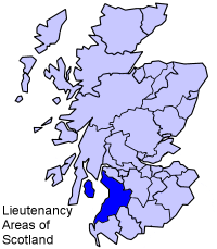
Ayrshire and Arran is a lieutenancy area of Scotland. It consists of the council areas of East Ayrshire, North Ayrshire and South Ayrshire. The area of Ayrshire and Arran is also a brand for tourist attractions.
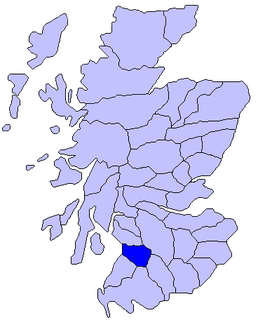
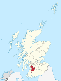
Kyle is a former comital district of Scotland which stretched across parts of modern-day East Ayrshire and South Ayrshire. It is said to be named after Coel Hen, a king of the Britons, who was reputedly killed in battle in this area and is said to be buried in a cairn near Mauchline.

Sorn is a small village in East Ayrshire, Scotland. It is situated on the River Ayr. It has a population of roughly 350. Its neighbouring village is Catrine. Sorn Castle lies just outside the village.

Drongan, a former mining village, is situated on the western edge of Ayrshire, some 8 miles from Ayr and 8 miles from Cumnock and has a population of 3,205 approx.

The River Ayr is a river in Ayrshire, Scotland. At 65 km (40 mi) it is the longest river in the county.

Ayr, Carrick, and Cumnock is a county constituency represented in the House of Commons of the Parliament of the United Kingdom. It was created for the 2005 general election from parts of the old Ayr and Carrick, Cumnock and Doon Valley constituencies. It has been represented since 2017 by Bill Grant of the Scottish Conservative Party.
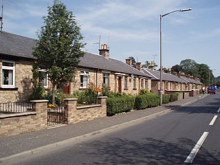
Fenwick is a village in East Ayrshire, Scotland, UK. In 2018, its population was estimated to be around 1,140.
The River Doon is a river in Ayrshire, Scotland.Its course is generally north-westerly, passing near to the town of Dalmellington, and through the villages of Patna, Dalrymple, and Alloway, birthplace of Robert Burns. The source of the Doon is Loch Enoch, high in the Galloway Hills.

Ochiltree is a village in East Ayrshire, Scotland, near Auchinleck and Cumnock. It is one of the oldest villages in East Ayrshire, with archaeological remains indicating Stone Age and Bronze Age settlers.

Kirkmichael is a village in South Ayrshire, Scotland, located between Patna, Maybole and Straiton. It was also a Civil Parish.

Straiton is a village on the River Girvan in South Ayrshire in Scotland, mainly built in the 18th century, but with some recent housing.

Rankinston is a village situated 3/4 mile off the B730, approximately 12 miles south east of the town of Ayr. Rankinston commands a panoramic view of over 20 miles north looking over the towns of Ayr, Prestwick and Troon.

St. Joseph's Academy is a Roman Catholic secondary school in New Farm Loch, Kilmarnock, Ayrshire, Scotland.
Drybridge is a village in North Ayrshire, Scotland. Drybridge is thus named because of the "dry bridge" over the Kilmarnock and Troon Railway, opened in 1812. The nearby "wet bridge" is the Laigh Milton Viaduct, the oldest surviving railway bridge in Scotland and possibly the world.
Lugar is a small village in East Ayrshire, southwest Scotland. Lugar is in Auchinleck Parish, Kyle District, Ayrshire. It is 1.5 miles (2.4 km) ENE of Cumnock, and about 1-mile (1.6 km) from Cronberry and 2 miles (3.2 km) from Gasswater. Lugar is a station on the Mauchline and Muirkirk branch of the Glasgow and South Western Railway. Lugar is about 16.5 miles (26.6 km) SE of Kilmarnock.
Crosshouse is a village in East Ayrshire about 3 kilometres west of Kilmarnock. It grew around the cross-roads of the main Kilmarnock to Irvine road, once classified as the A71 but now reduced in status to the B7081, with a secondary road running from Kilmaurs south to Gatehead and beyond towards Prestwick. The Carmel Water, a tributary of the River Irvine, flows through the centre of the village.
Barassie is a former village on the east shore of the Firth of Clyde in South Ayrshire, Scotland. Today it serves as a suburb outside the northern edge of Troon.

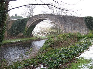
Sorn Castle is located by the River Ayr just outside the village of Sorn in East Ayrshire, Scotland. The castle comprises a medieval tower house, which was extended over the years, and remodelled in the Scots Baronial style by David Bryce in the 1860s. The castle is protected as a category A listed building.
Dalrymple is a village and parish in Ayrshire, Scotland, lying in the Doon Valley, on the north bank of the River Doon. The population is 1,347.